Teotihuacan
The most mysterious single great city in the pre-Columbian Americas and the city that the Aztecs themselves treated as a sacred place of pilgrimage — Teotihuacan, which at its peak around 450 CE was the sixth-largest city in the world with 150,000 inhabitants, was inexplicably abandoned around 550 CE, its founding people unknown and its original name lost, leaving behind pyramids that the Aztecs named, in wonder, “the birthplace of the gods.”
At a glance
Teotihuacan (the most anonymous single great ancient city in the Americas: the original name is unknown — the city is called “Teotihuacan” from the Nahuatl word meaning “birthplace of the gods” — the name the Aztecs gave to a city that had been abandoned for centuries when they found it; the founding people are unknown — the most precisely unidentified single major ancient urban culture in the Americas (competing theories include a Totonac, Proto-Nahua, or mixed-ethnicity origin — the most contested single ancient identity question in Mesoamerican archaeology); the UNESCO WHS 1987 as the Pre-Hispanic City of Teotihuacan; 4 million visits per year — the most visited single ancient city in Mexico and the second-most visited pre-Columbian site in the Americas (after Chichen Itza, described in CHO’s separate Chichen Itza place card)); the scale (at its peak c. 450 CE, Teotihuacan had approximately 150,000 inhabitants — the most populated single city in the pre-Columbian Americas at that date; the 6th-largest city in the world at 450 CE; the city covered 30 km² — the most extensively planned single pre-Columbian city in the Americas).
Key facts
- The Pyramid of the Sun: the most massive single pre-Columbian structure in North America — the Pyramid of the Sun (2.4 million tonnes of stone and fill (the most precisely weighted single pyramid in the pre-Columbian Americas); 225 m × 225 m base (the most precisely square-based single pyramid in any Mesoamerican city); 71 m high (the most precisely height-measured single pre-Columbian pyramid in North America: the same base perimeter as the Great Pyramid of Giza (the most precisely size-equated single pair of ancient pyramids in world heritage); the tunnel (the most consequentially discovered single underground feature at Teotihuacan: a 100-m long natural lava tube beneath the Pyramid of the Sun, discovered in 1971 — the most precisely lava-tube-based single pyramid foundation in the world; the tunnel ended in a cloverleaf-shaped chamber (the most precisely shamrock-shaped single ancient underground chamber in any pyramid in the Americas; believed to be a symbolic cave representing the underworld — the most precisely cosmological single underground feature in Mesoamerican architectural symbolism))
- The Temple of the Feathered Serpent and human sacrifice: the most extensively sacrificed single pyramid foundation in the Americas — the Temple of the Feathered Serpent (the Templo de la Serpiente Emplumada; in the Ciudadela compound (the most precisely palace-enclosure-adjacent single ceremonial compound in Teotihuacan)); the sacrificial deposits (the most precisely sacrifice-documented single temple foundation in Mesoamerican archaeology: the 1980s excavations found 196 sacrificial victims buried in the foundation deposits — the most precisely counted single foundation sacrifice in any Mesoamerican pyramid; all were adult males in military dress — the most precisely soldier-identity single sacrificial group in Teotihuacan; their hands were bound behind their backs — the most precisely restrained single sacrificial victim group in any pre-Columbian pyramid foundation); the Feathered Serpent iconography (the most internationally influential single Mesoamerican deity image: the Feathered Serpent (later named Quetzalcoatl by the Aztecs — the most consistently cross-civilisation single deity: the same deity appears at Teotihuacan, Tula, Chichen Itza, and Tenochtitlan — the most precisely multi-city single Mesoamerican deity tradition))
- The murals: the most extensively painted single ancient city in the Americas — the murals (Teotihuacan once contained approximately 3 km² of murals — the most extensively painted single pre-Columbian city in the Americas: every major building was painted with complex symbolic murals; the most extensively preserved murals are at the Palace of the Jaguars and the Palace of the Feathered Conches (the most precisely bird-instrument-themed single Teotihuacan palace); the Tepantitla compound (the most narratively complex single mural in Teotihuacan: the “Paradise of Tlaloc” mural (the most precisely afterlife-depiction-named single Teotihuacan mural) shows a richly detailed paradise scene with figures swimming, playing, and picking flowers — the most precisely joyful single afterlife in any Mesoamerican mural)
- Heritage: UNESCO World Heritage Site, Pre-Hispanic City of Teotihuacan, inscribed 1987
- GPS: 19.6925° N, -98.8438° E
History
The rise (the most rapidly urbanised single pre-Columbian city: Teotihuacan grew from a small settlement around 100 BCE to a major city of 150,000 by 450 CE — the most precisely urbanisation-timed single ancient city in the Americas; the most cosmopolitan single pre-Columbian city: evidence of distinct barrios (neighbourhoods) for Zapotec, Mayan, and Gulf Coast people — the most ethnically diverse single ancient American city); the influence (the most broadly influential single pre-Columbian city: Teotihuacan’s influence extended over 1,000 km in every direction — the most geographically reach-extensive single Mesoamerican city; Teotihuacan pottery and iconography have been found in Maya cities 1,500 km away — the most widely distributed single Teotihuacan trade goods); the fall (the most precisely arson-documented single ancient city collapse: around 550 CE, the city’s ceremonial and elite buildings were systematically burned — the most precisely targeted single ancient city destruction (only the upper-class buildings were burned; the lower-class residential areas were not — the most precisely class-targeted single ancient urban burning in the history of pre-Columbian civilisation; whether by internal revolt or external attack is unknown — the most debated single ancient city fall in Mesoamerican history)); UNESCO WHS 1987.
What you see
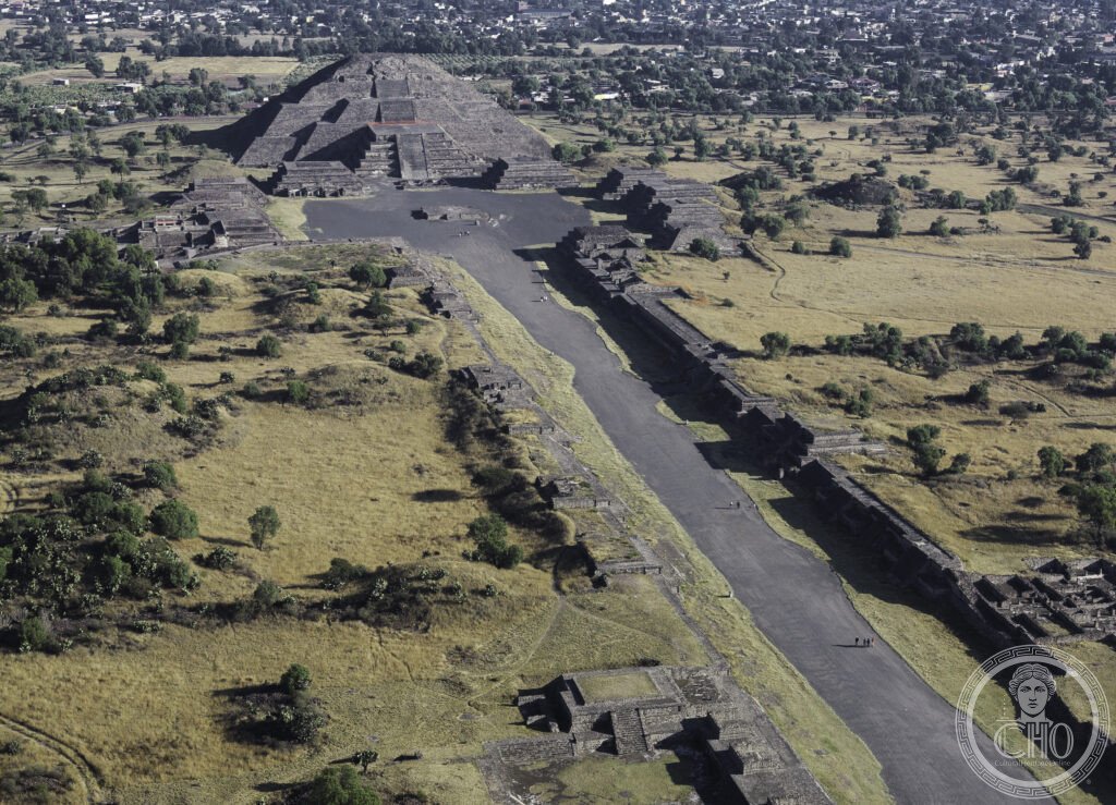
The visit (the most physically demanding single major Mesoamerican heritage visit: 4 km of Avenue of the Dead; climbing the Pyramid of the Sun (248 steps; 71 m) is the most adrenaline-exhausting single pyramid climb in the Americas; the site is open 9am–5pm; the most strongly recommended arrival strategy: arrive at opening (9am) to avoid the afternoon sun and tour-bus peak (11am–2pm)); the essential sequence (the Ciudadela + Temple of the Feathered Serpent (start here: the most iconographically complex single compound; the serpent heads on the temple facade — the most precisely feathered-serpent-carved single 3rd-century CE stone gallery in the Americas); the Avenue of the Dead walk (4 km south to north; the most cosmologically directed single heritage walk in Mexico); the Pyramid of the Sun (climb for the panoramic view — the most panoramically Mesoamerican single summit in the Americas; the Pyramid of the Moon terrace at the north end — the most precisely city-overlook single pyramid position at Teotihuacan: the view down the entire Avenue of the Dead is the most cinematically composed single ancient city panorama in the Americas).
Practical information
- Getting there: from Mexico City (the most frequently used single departure point: the Autobuses del Norte terminal (Metro Autobuses del Norte, Line 5) serves Teotihuacan directly by Autobuses Teotihuacan bus (1h; the most cost-effective single heritage day-trip from any Latin American capital: approximately 120 MXN (€6) return — the most affordable single UNESCO site access in North America); by car (the most flexible approach: 50 km north-east of Mexico City on Federal Highway 132D; 45 min without traffic — the most variable single traffic condition on any major Mexican heritage approach road); guided tours from Mexico City (the most informative single approach: authorised guides explain the cosmological alignment of the pyramid axes — the most precisely astronomical single guided tour content in any Mesoamerican heritage site))
- Mexico City — the most historically stratified single capital city in the Americas: 50 km south-west (45 min drive or bus) — Mexico City (the Zócalo (the most politically consequential single public square in the Americas: the site of the Aztec Templo Mayor (the most precisely temple-under-cathedral single archaeological layering in any American city); the Metropolitan Cathedral of Mexico City (the most precisely built-over single Aztec temple structure in the Americas: built on the stones of the destroyed Aztec Templo Mayor (1573–1813 CE — the most precisely sequentially constructed single colonial cathedral in North America); the Templo Mayor Museum (the most precisely excavated single Aztec site in a major city: discovered accidentally during a 1978 electricity installation — the most precisely accidental single major Mesoamerican discovery in the 20th century; the Stone of Tizoc and the Coyolxauhqui disc — the most precisely circular single Aztec narrative sculpture in any museum))
- Xochimilco (UNESCO WHS 1987): the most precisely ancient floating gardens in the Americas — Xochimilco (20 km south of Mexico City; the “Mexican Venice” — the most precisely Venice-analogised single Latin American canal network (the most precisely inaccurate single heritage comparison in Mexican tourism: Xochimilco is not at all like Venice, but the tag persists); the trajineras (the most festively decorated single flat-bottomed boats in any Latin American UNESCO heritage waterway: flower-garlanded and family-name-painted; musicians and food vendors pole alongside in smaller boats — the most precisely floating-cantina single heritage experience in the Americas)); the chinampas (the most ancient single continuously cultivated raised agricultural plots in the Americas: the Aztec floating gardens (600 CE origins — the most precisely dated single ancient raised-bed agricultural system in Mesoamerica); UNESCO WHS 1987 as part of Historic Centre of Mexico City and Xochimilco)
Getting there
From Mexico City: Autobuses Teotihuacan from Autobuses del Norte terminal (Metro Line 5; 1h; ~120 MXN return). By car: 50 km on Federal Highway 132D, 45 min. Open 9am–5pm; arrive at opening to avoid midday heat and crowds. GPS: 19.6925, -98.8438.
Nearby
- Mexico City Historic Centre (UNESCO WHS 1987) — 50 km south-west (45 min); Aztec Templo Mayor + Metropolitan Cathedral — described in Practical section; essential Mexico itinerary: Teotihuacan (morning, full day) + Mexico City Historic Centre (1–2 days)
- Xochimilco (UNESCO WHS 1987) — 70 km south (1h from Teotihuacan; Metro + bus from Mexico City); most ancient continuously cultivated floating gardens in Americas — described in Practical section
- Chichen Itza (UNESCO WHS 1988) — 1,200 km south-east (1h 30min flight to Mérida or Cancún; or 3-day bus/overnight); the other great pyramid city of Mexico’s pre-Columbian heritage — described in CHO’s separate Chichen Itza place card; the ideal Mexico cultural circuit: Mexico City + Teotihuacan (3 days) + Oaxaca (2 days: Monte Albán UNESCO WHS 1987 — the most impressively hilltop-positioned single Zapotec city in Mexico) + Yucatán (Chichen Itza + Uxmal: 3 days)
Sources
- Wikipedia, Teotihuacan; Pyramid of the Sun; Avenue of the Dead; Temple of the Feathered Serpent, Teotihuacan, accessed June 2026
- UNESCO, Pre-Hispanic City of Teotihuacan, WHS reference 414, inscribed 1987
- René Millon, Urbanization at Teotihuacan, Mexico, University of Texas Press, 1973
Find it on the map
See this place and what’s around it →📷 Diventa un fotografo di Cultural Heritage Online
Condividi le tue foto dei luoghi: restano pubblicate con la tua firma come autore. Più vengono viste, più ti fai conoscere — e presto un concorso premierà le foto più apprezzate.
Accedi o registrati gratis per aggiungere una foto