
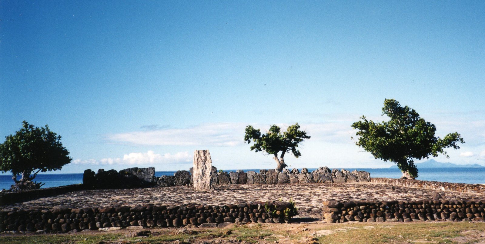
The most sacred site in ancient Polynesia and the spiritual centre from which the great voyaging migrations that settled Hawaii, New Zealand, and Easter Island were organised — a coral-slab platform on Raiatea island that connected chiefs, gods, and navigators across 7 million square kilometres of ocean. UNESCO World Heritage Site, 2017.
At a glance
On the island of Raiatea in the Society Islands of French Polynesia, the marae of Taputapuātea is a rectangular stone ceremonial platform approximately 43 metres long and 7 metres wide, surfaced with coral slabs. For centuries it was the most sacred site in the entire Polynesian triangle: the spiritual, political, and genealogical centre of Ra’iatea society, and the place from which the great Polynesian migrations that populated Hawaii, New Zealand, the Cook Islands, and Easter Island were organised and sanctified. UNESCO inscribed the site in 2017, recognising it as the origin point of one of humanity’s greatest ever maritime migrations.
Key facts
- Location: Raiatea, Society Islands, French Polynesia
- Coordinates: 16°43′36″S 151°27′8″W
- Type: Sacred ceremonial marae (stone platform)
- Dimensions: c. 43 m long × 7 m wide, surfaced in coral slabs
- Period of use: c. 1000–1800 AD (Pre-contact Polynesian)
- UNESCO: World Heritage Site, inscribed 2017
- Cultural significance: Spiritual centre of Polynesian triangle; seat of the god ʻOro; origin of Pacific-wide voyaging networks
History and significance
The word marae (or me’ae in some dialects) denotes a sacred ceremonial platform where priests communicated with the atua (gods), chiefs received their authority, sacrificial rites were performed, and the genealogical chains connecting living people to divine ancestors were recited and renewed. Taputapuātea was the most prestigious of all Polynesian marae for two reasons.
First, it housed the ahu (altar) of ʻOro, god of war and fertility — the most powerful deity in the late Polynesian pantheon. Second, the maro ʻura, the red feather girdle that was the ultimate symbol of chiefly authority across the Pacific, was kept and transferred here. Any chief wishing to claim supreme authority across the far Pacific needed to receive sanctification at Taputapuātea: the site was, in essence, the political and sacred capital of a dispersed ocean civilisation.
The site’s reach was geographically encoded: marae that wished to claim connection to Taputapuātea incorporated a stone physically transported from it. This practice created a network of stone-anchored sacred genealogies stretching across the Pacific — a physical web of religious and political legitimacy operating across 7 million square kilometres of open ocean, maintained not by armies or roads but by coral stones and oral genealogy.
Taputapuātea also marks the departure point for the great Pacific voyaging canoes. Oral tradition holds that the deliberate settlement of the far Pacific — New Zealand (Aotearoa), Hawaii, Easter Island (Rapa Nui) — was planned and launched from Raiatea over centuries, using star navigation, ocean swell reading, cloud formation, and the migration patterns of birds as instruments across the world’s largest ocean. These voyagers built double-hulled waka hourua (voyaging canoes) capable of sailing thousands of kilometres against the prevailing wind, and they did so repeatedly and intentionally: Polynesian settlement of the Pacific is now understood to be one of the most ambitious programmes of deliberate exploration in human prehistory.
What you see
The marae consists of a large rectangular stone platform — the ahu or altar — approximately 43 metres long and 7 metres wide, faced and surfaced with coral slabs of varying sizes. The platform rises in steps and is surrounded by an open ceremonial court (marae proper) also paved with coral, where ritual gatherings, investitures, and sacrificial rites took place. Upright stone slabs (unu) once lined the edges, representing ancestral presences.
The broader Taputapuātea complex sits within a landscape that integrates land and lagoon: the marae faces the sea, with the mountain interior of Raiatea behind it, placing the site at the interface between the terrestrial world of ancestors and the oceanic world of voyaging and divine contact. The surrounding landscape of Raiatea itself is inscribed as part of the UNESCO property, recognising the indissoluble connection between the sacred site and its navigational and cultural geography.
The Polynesian voyaging world
Understanding Taputapuātea requires understanding the scale of Polynesian seafaring achievement. The Polynesian triangle — Hawaii in the north, New Zealand in the southwest, Easter Island in the east — covers approximately 18 million square kilometres of open ocean, making it the largest cultural sphere ever created before the age of European sail. The deliberate navigation of this ocean, using non-instrumental techniques of extraordinary sophistication, remains one of the most impressive achievements of human exploration.
Taputapuātea was not merely the religious centre of this world: it was its institutional foundation. The authority of chiefs throughout the Pacific was validated by connection to Raiatea. The genealogies recited at the marae linked living rulers to the gods and to the original voyagers, providing a legitimating narrative that spanned ocean and generation alike. When European contact disrupted these systems in the late 18th century, Taputapuātea’s active role faded — but the site retained its identity in oral tradition as the navel (pito) of the Polynesian world.
Practical information
- Access: Located on the east coast of Raiatea island, French Polynesia. Raiatea has an airport with regular connections from Papeete (Tahiti), approx. 45 minutes by air.
- From the airport: The marae is approximately 10 km south of Uturoa (Raiatea’s main town); rental car or organised tour recommended.
- Opening hours: Site accessible during daylight hours; interpretive centre on site.
- Admission: Free to enter the marae grounds; interpretive centre may charge a small fee.
- Guided tours: Available from Uturoa; highly recommended to understand the oral traditions and genealogical significance of the site.
- Respectful visiting: The site remains spiritually significant to Ma’ohi (local Polynesian) communities; walk quietly and follow any posted guidance about restricted areas.
- Best time to visit: May–October (dry season); avoid cyclone season (November–April).
Getting there
Raiatea is served by Air Tahiti from Papeete (Faa’a International Airport) with multiple daily flights. International connections via Papeete include Air France, Air Tahiti Nui, and Air New Zealand. No direct international flights land on Raiatea. From Uturoa, the island’s main settlement, the marae is reachable by rental car in approximately 15–20 minutes heading south along the coastal road on the eastern side of the island.
Inter-island ferries also connect Raiatea to Tahaa (a short crossing), Bora Bora, and Huahine — making the Society Islands navigable by sea for visitors wishing to explore the broader context of Polynesian heritage across the group.
Nearby
- Raiatea island interior: The sacred peak of Mount Temehani, home to the endemic tiare apetahi flower, with hiking trails through dense forest.
- Tahaa: Adjacent island (shared lagoon with Raiatea) known for vanilla plantations and pearl farms; accessible by short ferry.
- Bora Bora: 50 km north, accessible by air or ferry; its own marae structures survive amid the famous lagoon landscape.
- Huahine: Neighbouring Society Island with one of the most intact archaeological marae complexes in French Polynesia (Maeva village), presenting a complementary view of traditional Polynesian settlement patterns.
Sources
- UNESCO World Heritage List — Taputapuātea (2017): whc.unesco.org/en/list/1529
- Wikipedia — Taputapuātea
- Kirch, Patrick V. — On the Road of the Winds: An Archaeological History of the Pacific Islands before European Contact (University of California Press, 2017)
- Finney, Ben R. — Voyage of Rediscovery: A Cultural Odyssey through Polynesia (University of California Press, 1994)
Find it on the map
See this place and what’s around it →📷 Become a Cultural Heritage Online photographer
Share your photos of places: they stay published under your name as the author. The more they're seen, the more you get noticed — and soon a contest will reward the most appreciated photos.
Log in or sign up free to add a photo