Surtsey (1963): l’isola vulcanica nata dal mare davanti all’Islanda
Il 14 novembre 1963, a poche miglia a sud dell’Islanda, il mare cominciò a ribollire e dal fondale emerse un’isola di lava e cenere: Surtsey. Nel giro di tre anni raggiunse 2,7 km², poi cominciò a sgretolarsi sotto l’erosione delle onde. Oggi misura 1,3 km², è completamente disabitata e aperta solo agli scienziati: un laboratorio naturale unico al mondo per studiare come la vita colonizza un territorio vergine — e dal 2008 è Patrimonio UNESCO.
At a glance
Surtsey is a volcanic island that emerged from the North Atlantic on 14 November 1963, following an underwater eruption that began 130 metres below sea level in the Vestmannaeyjar (Westman Islands) archipelago off Iceland’s south coast. The eruption lasted until 1967, building an island of basalt and tephra that reached its maximum extent of 2.7 km² before wave erosion began reducing it. Today Surtsey measures about 1.3 km². Since its formation it has been closed to all but authorised researchers and has become the world’s most closely studied example of primary ecological succession — the process by which life colonises completely new land. Inscribed by UNESCO in 2008.
Key facts
- UNESCO: World Heritage since 2008 (Surtsey, ref. 1267)
- Born: 14 November 1963, from an underwater eruption 130 m below sea level
- Eruption: lasted until 1967; island reached maximum 2.7 km²
- Today: about 1.3 km² and still shrinking due to wave erosion
- Access: restricted to scientists only; no tourism permitted
- Ecology: the world’s most closely monitored example of primary ecological succession
History
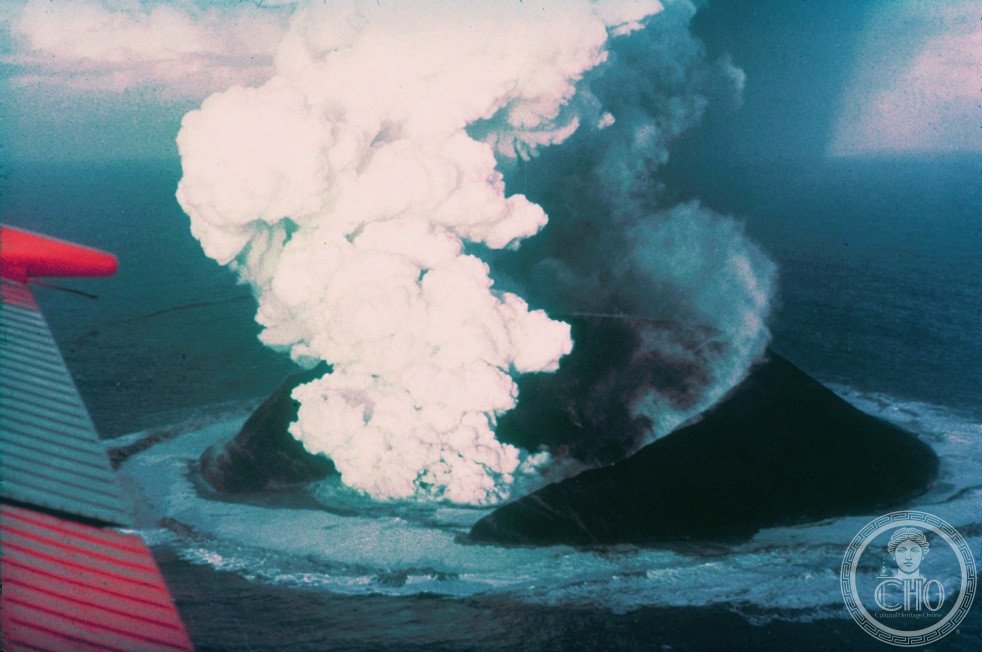
The submarine eruption that created Surtsey began on 8 November 1963, at a depth of 130 metres on the Mid-Atlantic Ridge. Six days later, on 14 November, the island broke the surface. The eruption was witnessed by a fishing boat crew who initially thought they were seeing a ship on fire. The island was named after Surtr, the fire giant of Norse mythology. As the eruption continued for nearly four years, Surtsey grew rapidly; at its maximum in 1967 it covered 2.7 km² and rose to 174 metres above sea level.
Because Surtsey was immediately placed under strict scientific protection, it has provided an unparalleled natural experiment: researchers have observed the arrival of the first bacteria, fungi, mosses, vascular plants, insects, seabirds and seals over more than six decades, documenting how life colonises new land with no prior history. The island was inscribed by UNESCO in 2008 specifically for its outstanding universal value as a natural laboratory.
What you see
Surtsey cannot be visited by the public; access is restricted to authorised scientists and officials. Photographs show a black-lava island of lava fields, sea cliffs and sandy beaches, with low vegetation and colonies of nesting seabirds (including Atlantic puffins and northern gannets). The island can be seen from the Vestmannaeyjar archipelago on a clear day.
The process of ecological succession — now including mosses, grasses, herbs and a growing seabird colony whose droppings fertilise the soil — continues to unfold in real time, watched by scientists from the Surtsey Research Society.
Practical information
- Access: closed to the public; accessible only with scientific authorisation
- Nearest base: Heimaey, the main island of Vestmannaeyjar, is accessible by ferry from Þorlákshöfn
- Viewpoint: visible on clear days from Heimaey; boat tours of the archipelago sometimes pass nearby
- Documentation: the Surtsey Research Society publishes research online
Getting there
Surtsey is 32 km south-west of the Vestmannaeyjar archipelago and 33 km from Iceland’s south coast. The nearest inhabited island, Heimaey, is reached by ferry from Þorlákshöfn or by air from Reykjavík. Surtsey itself is off-limits to the public. GPS: 63.30° N, 20.61° W.
Nearby
- Heimaey — the Westman Islands’ main island, with the 1973 Eldfell eruption lava fields and Viking-age archaeology
- Þórsmörk — a mountain oasis in southern Iceland, accessible by 4WD
- Skógafoss & Seljalandsfoss — Iceland’s most iconic waterfalls on the south coast
Sources
- UNESCO World Heritage Centre — “Surtsey” (ref. 1267)
- Surtsey Research Society — surtsey.is, primary scientific publications
- Encyclopaedia Britannica — Surtsey
Find it on the map
See this place and what’s around it →📷 Diventa un fotografo di Cultural Heritage Online
Condividi le tue foto dei luoghi: restano pubblicate con la tua firma come autore. Più vengono viste, più ti fai conoscere — e presto un concorso premierà le foto più apprezzate.
Accedi o registrati gratis per aggiungere una foto