
Once the largest city in Southeast Asia before Angkor, this ancient Pyu settlement on the Irrawaddy River flourished as a major Buddhist centre and artistic hub.
At a glance
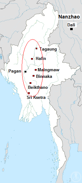
Sri Ksetra—meaning ‘Field of Fortune’—was the principal settlement of the Pyu people in Upper Myanmar. Its monumental brick walls enclosed approximately 1,477 to 1,857 hectares, making it a remarkable urban centre whose influence extended far beyond its walls. The city declined around the ninth century AD, though Pyu culture persisted into the twelfth century at Pagan.
History
The Pyu occupied several sites across Upper Myanmar, with Sri Ksetra recorded as the largest. Dating remains contested among scholars, with most material assigned to the seventh through ninth centuries AD, though recent scholarship suggests settlement began considerably earlier. Chinese pilgrims Xuanzang (648) and Yijing (675) both documented Sri Ksetra as an established Buddhist nation, referring to it as “Shh-li-cha‟-t‟o-lo.” The city’s prominence waned in the ninth century, with the final recorded Pyu inscriptions appearing on a twelfth-century stone at Pagan, inscribed in Pyu, Mon, Burmese and Pali.
What you see
Sri Ksetra’s defining feature is its massive brick defensive wall, which enclosed one of Southeast Asia’s most expansive urban areas. An extramural zone of comparable size extended beyond these fortifications, indicating a substantial peripheral settlement. Archaeological remains reveal the city’s Buddhist character through surviving stupas and votive objects.
Cultural significance
The site preserves the artistic and spiritual legacy of the Pyu civilization. Buddhism’s arrival sparked flourishing artistic production, with little material surviving from pre-Buddhist occupation. The quantity and quality of artefacts at Sri Ksetra attest to a visually sophisticated culture actively supported by Pyu patronage. This was a cosmopolitan centre whose documented connections to Chinese travellers placed it within continental Buddhist networks.
Key facts
- Country: Myanmar
- Location: Hmawza, along the Irrawaddy River
- Coordinates: 18.82°N, 95.32°E
- Walled area: 1,477–1,857 hectares
- Period: 7th–9th centuries AD (traditional dating); possibly earlier settlement
- Culture: Pyu Buddhist civilization
Practical information & getting there
Sri Ksetra is located near Hmawza in the Bago Region of Myanmar. The site remains largely unexcavated. Visitors should consult local authorities for access conditions and recommended guides with expertise in Pyu archaeology.
Sources & resources
Find it on the map
See this place and what’s around it →📷 Become a Cultural Heritage Online photographer
Share your photos of places: they stay published under your name as the author. The more they're seen, the more you get noticed — and soon a contest will reward the most appreciated photos.
Log in or sign up free to add a photoIs this page about you?
This page is read by travellers and heritage enthusiasts who find it on Google. Tell us how you are connected to this place and we will take it from there.