The birthplace of Tamerlane: the Green City
Shahrisabz — “Green City” in Persian — lies 80 kilometres south of Samarkand, separated from it by the Zarafshan mountain range. It was the birthplace of Timur (Tamerlane, 1336–1405), the conqueror who built an empire stretching from Anatolia to India and from the Caucasus to the Ganges, and it was here that he chose to build his palace, his mausoleum, and the monuments that would celebrate his dynasty. Today, the Old City of Shahrisabz preserves the most concentrated legacy of Timurid architecture outside Samarkand.
UNESCO inscription: the city of a conqueror
Inscribed in 2000, the Historic Centre of Shakhrisyabz was recognised as an outstanding example of medieval Central Asian urban planning and Timurid architectural achievement. The inscribed monuments trace the biography of a ruler who simultaneously devastated civilisations and patronised the arts to an extraordinary degree, raising buildings of staggering ambition from the ruins of cities he had destroyed.
The Ak-Saray Palace: the White Palace of the World
Timur began his palace in Shahrisabz in 1380, intending it to be the most magnificent structure in the world. The Persian historian Clavijo, who visited in 1404, described a building of supernatural grandeur: a portal 65 metres high, its facade covered in blue, gold, and white tilework with an inscription reading “If you challenge our power, look at our buildings.” Only the two surviving pylons of the entrance portal — still rising 38 metres — give a sense of what was lost to earthquake and neglect.
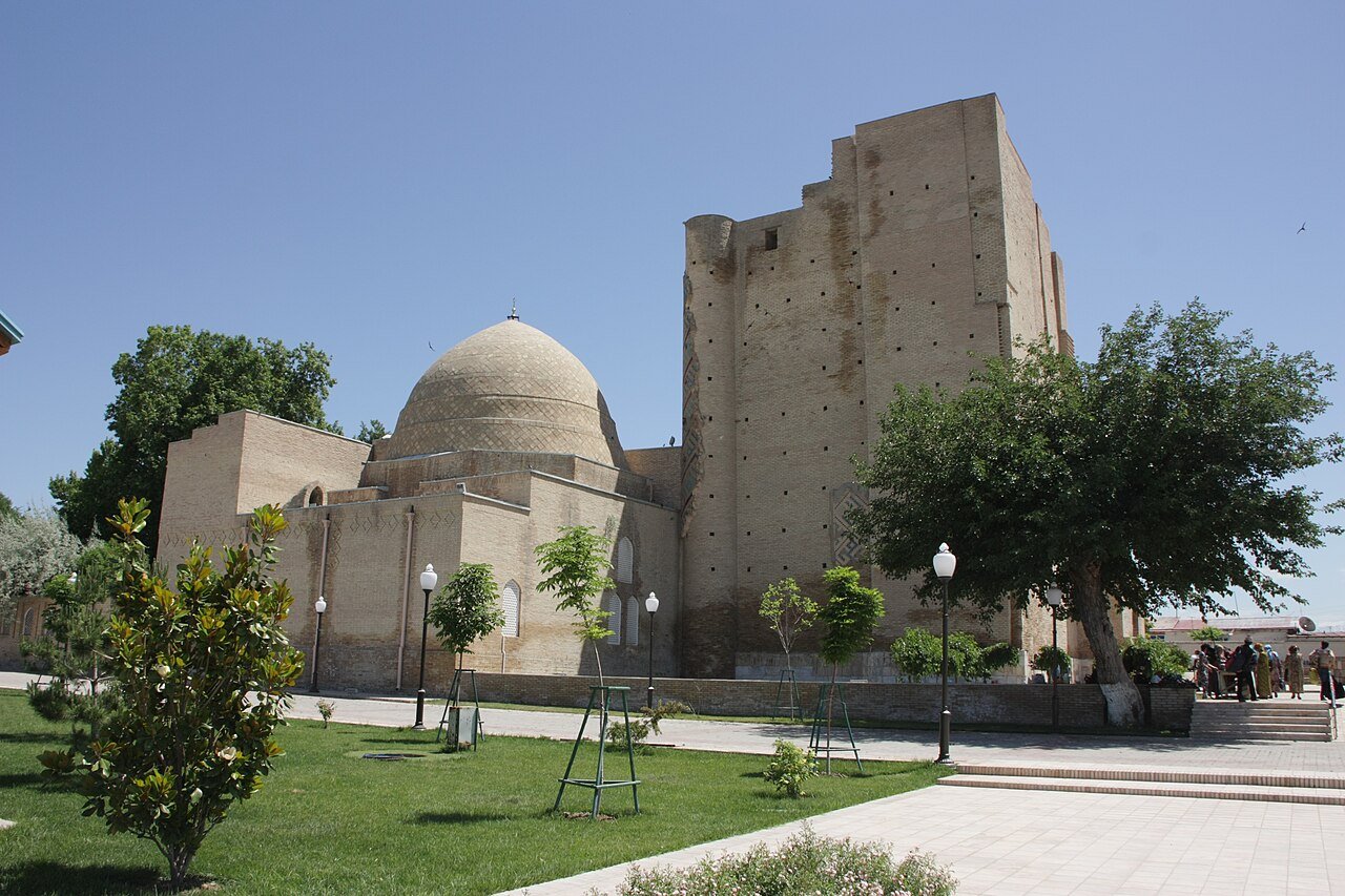
The Kok-Gumbaz Mosque and Dorus-Saodat complex
Adjacent to the palace ruins, the Kok-Gumbaz Mosque (Blue Dome, built 1437 by Timur’s grandson Ulugh Beg) serves as the Friday mosque of Shahrisabz and is still in active use. Near it stands the Dorus-Saodat (Seat of Power and Might), a mausoleum complex where Timur intended to be buried alongside his sons. His eldest son Jahangir is interred here; Timur himself is buried in Samarkand. The complex includes a crypt where 40 Sufi sheikhs lie in an underground chamber.
Timur between destruction and creation
Tamerlane’s legacy is difficult to hold in a single frame. His campaigns killed an estimated 17 million people — more than any other conqueror before the 20th century — yet the wealth looted from Delhi, Damascus, and Isfahan funded the extraordinary architectural patronage that produced the Registan in Samarkand, Gur-e-Amir, and the Bibi-Khanym mosque. In Shahrisabz, both aspects are visible: the scale of the buildings reflects power acquired by terror; the refinement of their decoration reflects the synthesis of Persian, Turkish, and Chinese artistic traditions that Timurid culture achieved.
A city in a mountain valley
Shahrisabz sits in a fertile valley between the Zarafshan and the Gissar mountain ranges, at 622 metres above sea level. Its setting — snow-capped peaks visible above the blue domes — is as striking as its monuments. The region produces the mulberries and silk for which the Silk Road was named; the local market still trades in dried fruits, spices, and silk fabric woven on traditional looms.
UNESCO and the controversy of modern reconstruction
In 2016, UNESCO placed Shahrisabz on the List of World Heritage in Danger following the demolition of large sections of the historic city centre to build modern boulevards and government buildings. The Uzbek government subsequently agreed to halt demolitions and undertake a heritage management plan. The site was removed from the danger list in 2023 after corrective measures were implemented — a rare successful case of UNESCO intervention reversing urban destruction.
Visiting Shahrisabz
The city is reached by road from Samarkand (2.5 hours) or by the recently upgraded mountain road through the Takhta-Karacha Pass. Day trips from Samarkand are the most common approach. The principal monuments are within walking distance of each other in the old city centre. A small museum near the Ak-Saray ruins displays archaeological finds from the site. The best time to visit is April–May or September–October, when the valley is neither too hot nor too cold.
Find it on the map
See this place and what’s around it →📷 Diventa un fotografo di Cultural Heritage Online
Condividi le tue foto dei luoghi: restano pubblicate con la tua firma come autore. Più vengono viste, più ti fai conoscere — e presto un concorso premierà le foto più apprezzate.
Accedi o registrati gratis per aggiungere una foto