Sassi di Matera
Two cave-cut districts carved into a limestone ravine, continuously inhabited from the Paleolithic to 1952 — one of the oldest living settlements in the Mediterranean.
At a glance
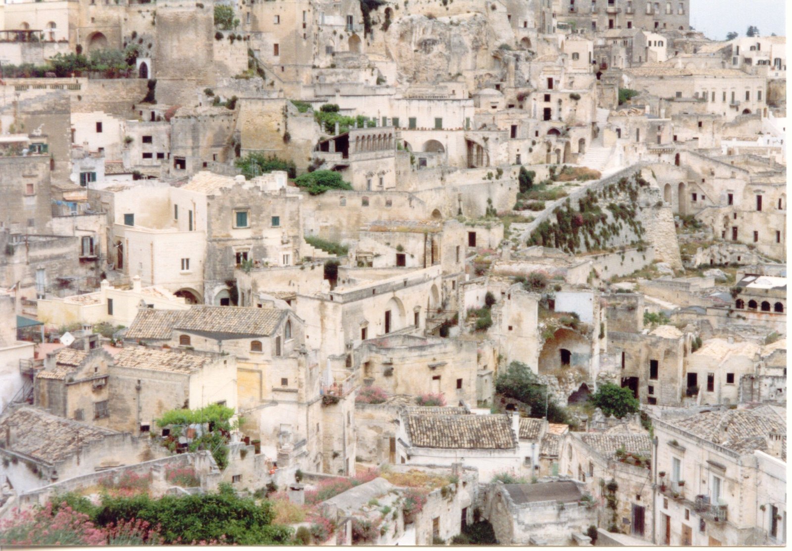
The Sassi are not ruins. They are two neighbourhoods — Sasso Caveoso and Sasso Barisano — quarried directly into the soft calcarenite of a Murgia ravine in southern Basilicata. The dwellings, churches and cisterns were excavated rather than built, then expanded with masonry façades over millennia. People lived here without interruption from prehistoric shelter through the twentieth century, when the Italian state evacuated the population under the 1952 Legge Speciale per Matera. Half a century of careful repopulation followed. UNESCO inscribed the site in 1993 as the world’s most outstanding intact example of a troglodyte settlement.
Key facts
- Location: Matera, Basilicata — southern Italy
- Coordinates: 40.6661° N, 16.6116° E
- Inscribed UNESCO: 1993, criteria iii, iv, v
- Districts: Sasso Caveoso (south, more archaic) · Sasso Barisano (north, denser masonry stratification)
- Civitas: the medieval ridge above the two Sassi, with the Romanesque cathedral (1268–1270)
- Rock-cut churches: more than 150 in the wider Matera territory (chiese rupestri)
History
Continuous human occupation in the Murgia caves is documented from the Paleolithic, with intensification during the Bronze Age and a substantial Byzantine–monastic phase between the 8th and 11th centuries, when Greek-rite monks fleeing iconoclasm carved hundreds of rupestrian churches and frescoed crypts into the surrounding ravines.
The Sassi as urban fabric crystallised in the late Middle Ages and Renaissance: a dense, stacked organism in which each house’s roof became the street of the house above, and water management was organised through an underground network of cisterns culminating in the Palombaro Lungo, a vast hypogeum beneath Piazza Vittorio Veneto.
By the twentieth century the Sassi had become a byword for southern poverty. Carlo Levi’s 1945 book Cristo si è fermato a Eboli brought national attention; in 1948 Palmiro Togliatti called the Sassi a “national shame.” The 1952 special law evacuated roughly 15,000 inhabitants to new neighbourhoods on the plateau above. Recovery began in the 1980s and accelerated after UNESCO recognition.
What you see
Walking the Sassi is reading a section through time. The lower levels are mostly cave: single-chamber dwellings cut into the rock, often with the original mangers and water channels still visible. Upper levels are masonry additions in the same calcarenite, so the boundary between built and quarried is deliberately ambiguous. Streets are also rooftops; staircases double as drainage.
Highlights inside the urban perimeter: the rock-cut churches of San Pietro Barisano, Santa Lucia alle Malve and Santa Maria de Idris; the Casa Grotta di Vico Solitario, a furnished cave-house museum showing peasant life pre-1952; and the Palombaro Lungo, a 15-metre-deep cistern carved as one continuous void.
Practical information
- Opening: the Sassi are an inhabited urban district — freely walkable 24/7. Individual rock-cut churches and museums have ticketed hours.
- Best season: April–June and September–October. July–August get hot and crowded; January–February evenings are visually striking but cold.
- Footwear: proper walking shoes — the streets are uneven calcarenite, often slippery in rain.
- Time needed: half a day for a first orientation, a full day with churches and the Civitas, two days to do the whole site justice.
Getting there
Matera has no commercial airport. The nearest gateways are Bari Karol Wojtyła (BRI, 65 km, ~70 min by car or shuttle bus) and Napoli Capodichino (NAP, 250 km). From Bari, the regional Ferrovie Appulo Lucane train links to Matera Centrale in about 90 minutes. From the train station it is a 10-minute walk down to the Sassi viewpoints; descent into the districts themselves is on foot only.
Nearby
- Parco della Murgia Materana — the ravine opposite the Sassi, with the largest concentration of rupestrian churches.
- Cripta del Peccato Originale — 9th-century frescoed crypt 14 km south, the “Sistine Chapel of cave painting.”
- Altamura — Norman cathedral and DOP bread, 20 km north in Puglia.
Sources
- UNESCO World Heritage Centre, “The Sassi and the Park of the Rupestrian Churches of Matera” (inscription dossier, 1993).
- Carlo Levi, Cristo si è fermato a Eboli, Einaudi 1945.
- Pietro Laureano, Giardini di pietra. I Sassi di Matera e la civiltà mediterranea, Bollati Boringhieri 1993.
- Ministero della Cultura, schede vincoli per la Civitas e i due Sassi.
Find it on the map
See this place and what’s around it →📷 Diventa un fotografo di Cultural Heritage Online
Condividi le tue foto dei luoghi: restano pubblicate con la tua firma come autore. Più vengono viste, più ti fai conoscere — e presto un concorso premierà le foto più apprezzate.
Accedi o registrati gratis per aggiungere una foto