Rujm el-Hiri (Gilgal Refaim)
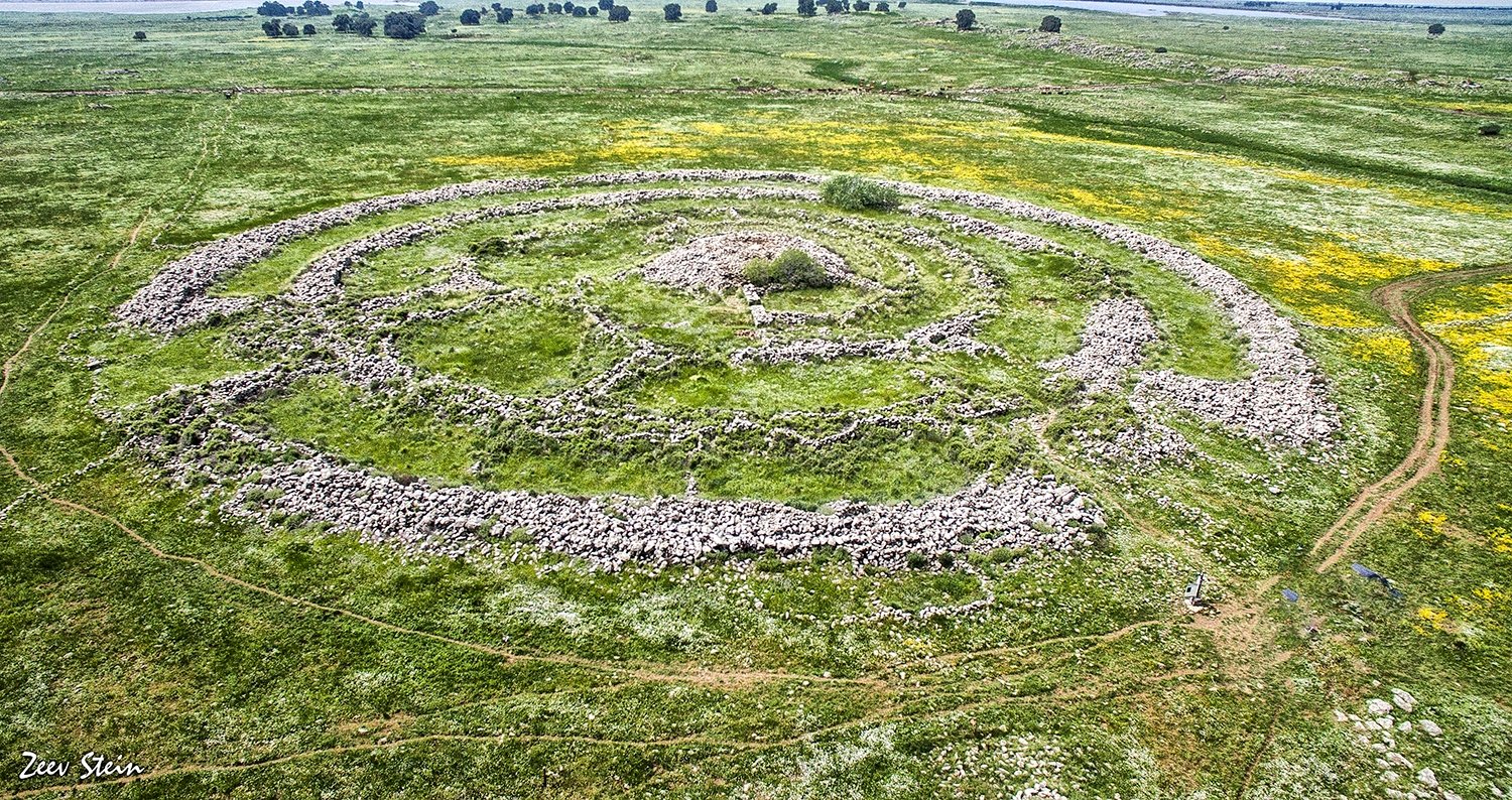
A massive Bronze Age monument of concentric basalt stone rings on the Golan plateau, Rujm el-Hiri is one of the largest ancient stone structures in the Middle East — its outer ring stretching 160 metres across — and a site whose purpose, nearly 5,000 years after its construction, remains an open question.
At a glance
Constructed from approximately 42,000 tonnes of unworked basalt stones, Rujm el-Hiri (“stone heap of the wild cat” in Arabic; “Wheel of Giants” in Hebrew) comprises five concentric rings and a central burial cairn. The outer ring measures about 160 metres in diameter. Construction is estimated to have begun around 3000–2700 BCE, during the Early Bronze Age, though the central burial cairn was added during the Middle Bronze Age (c. 2200–2000 BCE). The monument is aligned to the summer solstice sunrise, with the entrance passage oriented to greet the sun on the longest day. First studied scientifically by Yonathan Mizrachi and Moshe Kochavi in 1988, it is included on the UNESCO World Heritage tentative list. It sits in an area of the Golan plateau historically inhabited by pastoral nomads — making its scale and precision all the more remarkable.
Key facts
- Type: Concentric stone circle monument with central cairn
- Built: c. 3000–2700 BCE (Early Bronze Age); central cairn added c. 2200–2000 BCE
- Scale: Outer ring ~160 m diameter; five concentric rings total
- Material: ~42,000 tonnes of unworked local basalt stones
- Alignment: Entrance passage oriented to summer solstice sunrise
- Central cairn: Contains a Middle Bronze Age burial chamber
- Names: Rujm el-Hiri (Arabic: “stone heap of the wild cat”); Gilgal Refaim (Hebrew: “Wheel of Spirits/Giants”)
- First scientific study: 1988, Yonathan Mizrachi and Moshe Kochavi
- UNESCO status: On Israel’s tentative World Heritage list
History and interpretation
Rujm el-Hiri was built during the Early Bronze Age, a period when pastoralist and early urban societies were emerging across the Levant. The sheer labour involved — moving and stacking 42,000 tonnes of basalt without wheeled transport or metal tools — implies a substantial, organised community. Yet the surrounding landscape of the Golan plateau was inhabited primarily by pastoral nomads, not by settled agricultural towns capable of the kind of centralised political authority that drove monument construction elsewhere.
Theories about the site’s purpose range widely: a burial monument (supported by the cairn), a territorial marker signalling group identity or land rights, a seasonal gathering point for dispersed nomadic communities, or a calendar structure used to track agricultural and herding cycles. The summer solstice alignment is clear, but whether astronomy was the monument’s primary function or a secondary attribute remains debated.
The central cairn — a large stone tomb at the heart of the rings — was added some centuries after the main rings were built, during the Middle Bronze Age. This suggests the site retained cultural or religious significance across long periods and was reused by later communities. The Arabic name “Rujm el-Hiri” and the Hebrew “Gilgal Refaim” both reflect the monument’s enduring presence in the cultural memory of the region, though neither name sheds light on the intentions of its Bronze Age builders.
Serious archaeological investigation began only in 1988, led by Yonathan Mizrachi and Moshe Kochavi, and survey and excavation work has continued intermittently since. The site is included on the UNESCO World Heritage tentative list, pending nomination.
What you see today
From the ground, Rujm el-Hiri presents a series of low basalt stone walls — the remnants of the five concentric rings — radiating outward across the flat plateau. The scale is difficult to grasp at ground level; the full geometry, with its wheel-like plan, is only apparent from the air or from aerial photographs. The central cairn, standing somewhat higher than the surrounding rings, marks the burial chamber at the heart of the monument.
The site lies within a national park in the Golan Heights. The basalt stones are unworked and uncut, stacked without mortar — an approach that has proved remarkably durable across five millennia of weathering. Visitors walk among the rings on unpaved paths; the open plateau provides unobstructed views of the surrounding landscape and sky. There is minimal on-site interpretation infrastructure, so arriving with background knowledge enhances the visit significantly.
Practical information
- Location: Golan Heights (north-east Israel; status of the Golan Heights is disputed under international law)
- Access: Via Route 98 in the Golan Heights; within the Yehudiya Forest Nature Reserve area
- Admission: Nature reserve entry fees may apply; check with the Israel Nature and Parks Authority
- Best time: Around the summer solstice (c. 21 June) for the solstice alignment; spring and autumn for comfortable hiking
- Nearest town: Katzrin (~15 km W) — the main town in the Israeli-administered Golan Heights
- Note: Visitors should check current access conditions before travel
Getting there
Rujm el-Hiri is reached via Route 98 in the Golan Heights, accessible from the city of Katzrin approximately 15 km to the west. By car from Tiberias (on the Sea of Galilee), the drive takes roughly 45–60 minutes via Route 87 and Route 98. Public transport to the site is limited; a rental car or guided tour from Tiberias or the Golan is the most practical option. The site sits on an open plateau at around 1,000 metres elevation; robust footwear is recommended.
Nearby
- Dolmen fields of the Golan — the Golan plateau contains one of the highest concentrations of dolmens (Bronze Age megalithic tombs) in the world; many visible within a few kilometres of Rujm el-Hiri
- Katzrin Archaeological Museum — covers the archaeology and history of the Golan Heights from prehistoric to Byzantine periods (~15 km W)
- Sea of Galilee (Kinneret) — major landscape feature and archaeological region (~30 km W)
- Gamla Nature Reserve — dramatic canyon site with remains of a Jewish city destroyed by Rome in 67 CE (~20 km W)
Sources
- Mizrachi, Y. et al. (1996). “Rujm el-Hiri: A Megalithic Monument in the Golan.” Journal of the Israel Exploration Society 46(3–4).
- Freikman, M. & Getzov, N. (2014). “New light on the Rujm el-Hiri puzzle.” Journal of the Israel Prehistoric Society.
- Wikipedia contributors. “Rujm el-Hiri.” Wikipedia, The Free Encyclopedia. Accessed 2026-06.
- Israel Nature and Parks Authority — parks.org.il
Find it on the map
See this place and what’s around it →📷 Diventa un fotografo di Cultural Heritage Online
Condividi le tue foto dei luoghi: restano pubblicate con la tua firma come autore. Più vengono viste, più ti fai conoscere — e presto un concorso premierà le foto più apprezzate.
Accedi o registrati gratis per aggiungere una foto