Rio de Janeiro
The most scenically extravagant city on Earth and the place where the Atlantic Ocean, the Atlantic Forest, the Portuguese colonial baroque, and the 20th-century Art Deco converge beneath a Christ figure that has, since 1931, been visible from any ship approaching the coast of Brazil.
At a glance
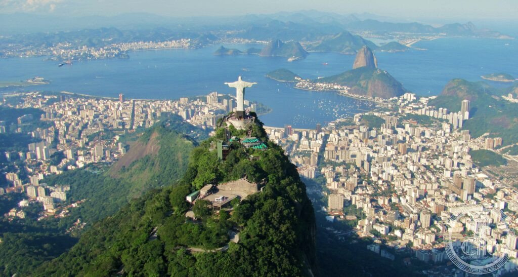
Rio de Janeiro (UNESCO WHS 2012 as “Rio de Janeiro: Carioca Landscapes between the Mountain and the Sea” — the most panoramically inscribed UNESCO WHS in South America (the inscription covers not a single monument but an entire urban landscape ensemble: the mountains, the forests, the beaches, and the bays); the most unusual UNESCO inscription in the Americas: a living city of 6.7 million people inscribed for its geographic beauty — the only major South American capital city inscribed primarily for its natural and scenic landscape rather than for its monuments or historic centre; the landscape (the most geologically dramatic urban setting in the world: the vertical granite inselbergs (Sugarloaf; Corcovado; the Two Brothers peaks (Dois Irmãos); the Pedra da Gávea (the world’s largest coastal monolith (844 m; freestanding granite with a near-vertical sea face; described in UNESCO nomination as the “most spectacular natural urban setting” in any city in the Americas); the Atlantic Forest (a remnant of the world’s most biodiverse rainforest; the Tijuca Forest (the largest urban tropical forest in the world (3,953 ha) was systematically restored between 1861 and 1874 by Dom Pedro II’s foresters — the most consequential single urban reforestation project in Brazilian history)).
Key facts
- Christ the Redeemer and Corcovado: the most recognisable statue in South America — Cristo Redentor (the Christ the Redeemer statue: 38 m tall; base 8 m; arms span 28 m; weight 635 tonnes; built from reinforced soapstone-tile-faced concrete; opened on 12 October 1931 by President Getúlio Vargas — the most politically attended single monument opening in Brazilian history; designed by Brazilian engineer Heitor da Silva Costa and modelled by French sculptor Paul Landowski (the most frequently misattributed public sculpture in South America: the statue is widely credited to Landowski alone, but da Silva Costa designed the pose and the engineering — the most consequential design collaboration in Brazilian heritage construction); the view from the Corcovado summit (704 m; the finest 360° panorama in any major city in the world: Guanabara Bay to the east, the Atlantic to the south, the Tijuca Forest below, the city’s Zona Norte to the north — the most geographically informative single viewpoint in any city in the Americas); the cog railway (the Trem do Corcovado: 3.8 km rack railway built in 1884 (the oldest rack railway in Brazil — the most reliably historic single tourist transport experience in Rio de Janeiro); the most atmospherically scenic approach to a monument in Brazil: the train passes through dense Atlantic Forest for 20 minutes before emerging at the summit))
- Sugarloaf Mountain (Pão de Açúcar): the most immediately recognisable mountain silhouette in South America — Pão de Açúcar (the Sugarloaf: 396 m; a bare granite monadnock rising directly from the entrance of Guanabara Bay; the name (the most frequently explained single geographic name in Rio: the shape resembles a loaf of refined sugar, the most important Portuguese colonial export from Brazil; OR the name comes from the indigenous Tupi phrase “Pau-nh-açuquã” (high, pointed, isolated hill) — the most actively debated etymology in Rio topography); the cable car (the first cable car in Brazil (1912 — the most historically pioneering single tourist infrastructure installation in Rio de Janeiro); the two-stage cable car (Praia Vermelha → Morro da Urca (230 m) → Sugarloaf summit (396 m))); the sunset from Sugarloaf (the most widely recommended single evening event in Rio by travel publications (The Guardian, Lonely Planet, Condé Nast Traveler, Le Monde: all four cite the Sugarloaf sunset as the single best experience in Rio — the most consistently recommended single heritage moment in South American tourism)))
- Carnaval — the largest street festival in the world: the most attended single cultural event in Brazil — Carnaval (the Rio de Janeiro Carnival: the largest street festival in the world (approximately 7 million people per day at its peak — the most attended single daily street event in the world; occurring over the 4 days before Ash Wednesday); the Sambódromo (the official parade venue: the 700-m concrete parade avenue designed by Oscar Niemeyer (1984) — the most precisely designed single piece of spectator infrastructure in any city in Latin America; 100,000 spectator seats; the Rio Carnival parade venue that Niemeyer designed in 90 days — the most rapidly designed significant piece of public architecture in Brazilian history); the samba schools (the most complex single performance organisation in the world: each escola de samba (neighbourhood-based samba school) presents a 60–90 minute allegorical pageant; the school uses 3,000–5,000 performers; the 12 highest-ranked schools in the Grupo Especial compete — the most intensive single cultural competition in Brazil))
- Heritage: UNESCO World Heritage Site, Rio de Janeiro: Carioca Landscapes between the Mountain and the Sea, inscribed 2012
- GPS: -22.9068° N, -43.1729° E
History
Portuguese colonial history (Rio de Janeiro was founded on 1 March 1565 by Estácio de Sá (the most precisely dated founding of any major South American city — the most precisely documented colonial founding act in Brazilian history: the founding battle against the French and Tamoio Indians at the foot of Pão de Açúcar on 1 March is the most militarily decisive single date in Rio’s colonial history; the name (January river — named after Guanabara Bay, which the first Portuguese explorers mistook for the mouth of a great river in January 1502 — the most consequentially mistaken single geographical identification in Brazilian topographical history)); the colonial capital (1763: Rio became the capital of the viceroyalty of Brazil — the most politically important single administrative transfer in Portuguese colonial South America; 1808: João VI of Portugal moved the entire Portuguese royal court to Rio after Napoleon’s invasion of Portugal — the most extraordinary single colonial capital event in the Americas: for 13 years (1808–1821) Rio de Janeiro was the capital of the Portuguese Empire (the only time a major European empire was ruled from its colonial territory — the most unusual single chapter in colonial administrative history)); 1960: capital transferred to Brasília (UNESCO WHS 1987)); UNESCO WHS 2012.
What you see
The essential Rio sequence (the Corcovado and Christ the Redeemer (described in Key Facts; best in the morning before clouds form — arrive at 8am for the clearest view; the queue management system (online booking required in peak season; the most organised single tourist access in Rio heritage sites)); the Sugarloaf cable car (described in Key Facts; the sunset visit; the 6–7pm gondola for the sunset across the bay); the Tijuca Forest (the world’s largest urban rainforest; the Cascatinha de Taunay waterfall (the most accessible 35-m waterfall inside any urban park in the world; 20 min walk from the park entrance); the Vista Chinesa (the Chinese Pavilion viewpoint: the finest panorama over the Lagoa Rodrigo de Freitas and the Leblon/Ipanema beaches from the forest — the most atmospheric single urban viewpoint in the Tijuca Forest)); the beaches (Copacabana: 4 km of urban beach — the most densely peopled public beach in the world on a summer weekend; Ipanema: the more residential alternative; the Ipanema sunset from the Pedra do Arpoador rock promontory — the most locally popular single sunset spot in Rio and the quietest of the major panoramic viewpoints).
Practical information
- Getting there: Galeão International Airport (GIG; the main international airport; 40 km north; 1h by BRT Transcarioca bus to Jardim Oceânico station; the most cost-effective single airport transfer in Rio at R$4 (approximately $0.75 USD); OR taxi (R$90–120; 45 min in off-peak hours); the real-time traffic situation (the most frequently misleading ETA in any South American city’s airport transfer: the 40 km can take 1h 30min in peak hours or 35 min at 6am — the most unpredictably variable single journey in Rio); Santos Dumont Airport (SDU; city-centre; 6 km from Copacabana; used for domestic flights only; the most convenient single airport for domestic connections to São Paulo (the most frequently flown Brazilian domestic route))); by bus from São Paulo (5h 30min; the most comfortable long-distance bus service in Brazil: the G7 and 1001 lines run double-decker sleeper buses (the most comfortable long-distance terrestrial connection between Brazil’s two largest cities))
- Iguaçu Falls (UNESCO WHS 1984 and 1986, Argentina + Brazil): the most powerful waterfall system in the world — Iguaçu Falls (1,600 km south-west; 2h flight from Rio; the 2,700-m wide waterfall on the border between Argentina and Brazil; the largest waterfall system in the world by width and total water volume (70,000 m³/s in the flood season — the most water moved over a continuous waterfall in the world; the Garganta del Diablo (Devil’s Throat): a U-shaped 700-m wide, 82-m high cataract — the most viscerally overwhelming single waterfall in the world (Eleanor Roosevelt, upon seeing the falls: “Poor Niagara” — the most diplomatically devastating single comparison in the history of waterfall tourism)); the two sides (the Argentine side (UNESCO WHS 1984): better for walking beneath the falls; the Brazilian side (UNESCO WHS 1986): better for the panoramic overview; the most comprehensive coverage of the falls requires one day on each side))
- Salvador da Bahia (UNESCO WHS 1985): the spiritual capital of Afro-Brazilian culture — Salvador (1,800 km north; 2h flight from Rio; the first capital of Brazil (1549–1763) and the largest city in the Bahia state; the Pelourinho historic centre (UNESCO WHS 1985): the largest and finest collection of Portuguese colonial architecture in the Americas (the most concentrated single colonial baroque townscape in any city in the Americas); the Candomblé (the Afro-Brazilian religion combining Yoruba, Fon, and Bantu traditions brought by enslaved West Africans (the most important single African religious tradition to survive in Brazil; Brazil received the largest number of enslaved Africans in the Americas (approximately 4 million — the most single largest enslaved African population in the Americas); Bahia was the port of entry for the majority — the most consequential single Brazilian state for the Atlantic Slave Trade); the blocos afro (the Afro-Brazilian carnival groups of Salvador: the most politically significant Carnaval tradition in Brazil; Ilê Aiyê (founded 1974 — the first all-Black bloco afro in Brazil, the most politically consequential single Carnaval founding in Brazilian cultural history))
Getting there
Galeão Airport (GIG) 40 km north (1h BRT bus R$4 / taxi 45min). Santos Dumont (SDU) for domestic. Online booking required for Corcovado/Christ Redeemer. Best morning visit: Corcovado 8am. Best evening: Sugarloaf sunset 6-7pm. GPS: -22.9068, -43.1729.
Nearby
- Iguaçu Falls (UNESCO WHS 1984/1986) — 1,600 km south-west (2h flight); the most powerful waterfall system in the world — described in Practical section; the essential Brazil nature circuit: Rio de Janeiro (3 nights: Corcovado + Sugarloaf + Tijuca + Ipanema sunset) + Iguaçu (2 nights: Argentine side day 1 + Brazilian side day 2) + optional return via São Paulo
- Petrópolis (Museu Imperial) and the Serra dos Órgãos — 65 km north (1h 30min by bus via the Serra Fluminense); the 19th-century summer capital of the Brazilian Empire and the finest mountain landscape accessible from Rio — Petrópolis (the Museu Imperial: the former summer palace of Dom Pedro II (the most historically significant single building in Petrópolis: the Crystal Palace (1884; an iron-frame greenhouse built in France and assembled in Brazil — the most directly imported single piece of European prefabricated architecture in 19th-century Brazil); the mountain scenery (the Serra dos Órgãos National Park: the Dedo de Deus (Finger of God) rock spire (1,692 m) — the most recognisable single rock spire in the Atlantic Forest; the most challenging single-day scramble accessible by bus from Rio))
- Paraty Historic Town (UNESCO WHS 2019) — 260 km south-west (4h by bus); the finest preserved 18th-century colonial port town in Brazil and the original Gold Road terminal — Paraty (the most intact single colonial Portuguese grid town in Brazil: the Historic Centre was closed to motor vehicles in 1966 (the most forward-thinking single urban conservation decision in Brazilian heritage history; the cobblestone streets flood deliberately at high tide — the most unusual single drainage engineering decision in any colonial Brazilian town: the street level was set slightly below the tideline so the sea washes the streets twice a day; the Cachaça (the Paraty region is the most important single cachaça-producing region in Brazil: the artisan cachaça distilleries in the surrounding hills produce Brazil’s finest craft spirit; the most essential single food-tourism product of the Paraty visit)
Sources
- Wikipedia, Rio de Janeiro; Christ the Redeemer; Sugarloaf Mountain; Tijuca Forest; Rio Carnival, accessed June 2026
- UNESCO, Rio de Janeiro: Carioca Landscapes between the Mountain and the Sea, WHS reference 1100, inscribed 2012
- Ruy Castro, Rio de Janeiro: Carnival under Fire, Bloomsbury, 2004
Find it on the map
See this place and what’s around it →📷 Diventa un fotografo di Cultural Heritage Online
Condividi le tue foto dei luoghi: restano pubblicate con la tua firma come autore. Più vengono viste, più ti fai conoscere — e presto un concorso premierà le foto più apprezzate.
Accedi o registrati gratis per aggiungere una foto