Qumran
The settlement beside the Dead Sea where a Jewish sect hid the oldest known Biblical manuscripts in eleven limestone caves — and where a Bedouin shepherd’s chance discovery in 1947 rewrote the early history of the Bible.
At a glance
Qumran is a plateau on the north-western shore of the Dead Sea, between the cliff face above and the shoreline 2 kilometres below. The site itself — a communal compound of scriptoria, refectories, cisterns, and cemeteries — was occupied by the Essenes, a Jewish sect, from roughly 150 BC until its destruction by Roman legions in 68 AD. The eleven caves in the adjacent cliffs yielded, between 1947 and 1956, approximately 981 manuscripts and fragments: the Dead Sea Scrolls. These include the oldest surviving copies of nearly every book in the Hebrew Bible, some dating to the 3rd century BC, and the most complete ancient Biblical manuscript known — the Great Isaiah Scroll, recovered intact in Cave 1 in 1947. The site was excavated by Dominican priest Roland de Vaux between 1951 and 1958.
Key facts
- Location: West Bank, 1.5 km from the Dead Sea shore — 31.7423° N, 35.4575° E (Google Maps)
- Period: c. 8th century BC (Iron Age remains); Essene settlement c. 150 BC – 68 AD; scroll deposit c. 250 BC – 68 AD
- Dead Sea Scrolls: Approximately 981 manuscripts and 15,000 fragments from 11 caves; written in Hebrew, Aramaic, and Greek
- Oldest Biblical texts: Fragments dating to the 3rd century BC — one thousand years older than the previously known Hebrew manuscripts
- Cave 4: The richest scroll cave, yielding 15,000 fragments from over 500 manuscripts; visible from the main site
- Discovery: Cave 1 scrolls found by Bedouin shepherd Muhammad Edh-Dhib in 1947; Cave 4 found by archaeologists in 1952
- Excavation: Roland de Vaux, 1951–1958, École Biblique et Archéologique Française de Jérusalem
History
Iron Age remains at Qumran — pottery and a circular cistern dated to the 8th–7th centuries BC — suggest the plateau was used long before the Essenes arrived. The Essene settlement began around 150 BC, during the reign of the Hasmonean dynasty, possibly as a response to what the group perceived as the corruption of the Jerusalem priesthood. The Essenes were a Jewish sect committed to ritual purity, communal life, and the intensive copying of scripture; the substantial scriptorium identified at Qumran, with its long narrow tables and inkwells still containing dried ink, was where scholars believe the majority of the discovered manuscripts were produced.
In 68 AD, two years before the destruction of Jerusalem’s Second Temple, the Roman Tenth Legion marched through the Jordan Valley. The Essenes apparently hid their library in the surrounding caves — wrapped in linen, sealed in ceramic jars — before the community was destroyed. The jars preserved the manuscripts in the Dead Sea’s hyper-dry climate for nearly two thousand years. On a winter day in 1947, a Bedouin shepherd named Muhammad Edh-Dhib, searching for a lost goat on the cliffs above Qumran, threw a stone into a cave opening and heard the sound of shattering pottery. Inside were seven intact scroll jars. He brought the scrolls to a Bethlehem antiquities dealer; within months the significance was recognised. Cave 1 was formally excavated in 1949; over the following seven years, ten more caves yielded material.
Roland de Vaux excavated the settlement itself between 1951 and 1958, identifying the buildings and proposing the Essene identification that became the scholarly consensus. The manuscripts were distributed between Jordan and Israel after the 1967 war; the major scrolls are now divided between the Israel Museum’s Shrine of the Book in Jerusalem and the Jordan Museum in Amman. The publication of all scroll fragments was completed only in 2001, after decades of restricted access that generated considerable controversy.
What you see
The settlement ruins are compact and clearly labelled: the large rectangular cisterns connected by channels that fed the community’s purification baths (miqvaot), the cylindrical tower at the complex’s north end, the long room interpreted as the scriptorium (where two mud-brick writing benches and inkwells were found), and the refectory — a long narrow room that still holds a stack of over a thousand ceramic plates and bowls exactly where they were abandoned in 68 AD. The plateau’s surface is powdery limestone that reflects the Dead Sea light upward from below; the heat in summer is genuine desert heat.
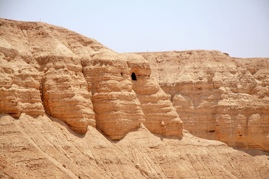
Cave 4, where the majority of manuscript fragments were recovered, is visible as a dark opening in the opposite cliff face across a narrow ravine — accessible by a steep path from the main site. Standing at its entrance, with the Qumran compound directly below and the Dead Sea’s flat silver surface three kilometres east, gives scale to the act of hiding: the jars would have been carried up this path in the dark, at speed, by people who knew the army was coming.
Practical information
- Opening hours: Daily 8:00–17:00 (Friday until 16:00); closed Yom Kippur
- Tickets: Entrance to the national park includes site access and visitor centre with replica scrolls and audiovisual introduction; Cave 4 path included
- Best season: October–April; summer temperatures on the Dead Sea shore regularly exceed 40°C; there is almost no shade on-site
- What to wear: Hat and sun protection essential; light clothing; comfortable shoes (rocky uneven terrain)
- Time needed: 1.5–2 hours for site, visitor centre, and Cave 4 path
- Combination: Usually visited with the Dead Sea shores immediately below and Ein Gedi nature reserve (20 km south)
Getting there
Qumran is located on Route 90, the Dead Sea highway, approximately 50 kilometres south-east of Jerusalem (45 minutes by car) and 20 kilometres north of Ein Gedi. There is no public bus service directly to the site; visitors from Jerusalem typically rent a car or join organised tours. The site is within the Palestinian Authority’s Area C, administered by Israel’s Israel Nature and Parks Authority; Israeli vehicle insurance covers travel on Route 90 without restriction. From Tel Aviv, the drive is approximately 90 minutes via Jerusalem or the shorter Jordan Valley highway route.
Nearby
- Dead Sea swimming beaches — 3 km east: the lowest point on earth (430 m below sea level); several resort beaches with facilities
- Ein Gedi Nature Reserve — 20 km south: freshwater springs and waterfalls above the Dead Sea shore; David’s hideout from Saul (1 Samuel 24); excellent wildlife
- Masada — 45 km south: Herod’s clifftop palace-fortress and the site of the final Jewish revolt against Rome (73 AD); UNESCO World Heritage Site; accessible by cable car
- Shrine of the Book, Jerusalem — 50 km west: the purpose-built museum housing the Great Isaiah Scroll, the Habakkuk Commentary, and other major Qumran finds
Sources
- de Vaux, Roland. Archaeology and the Dead Sea Scrolls. British Academy / Oxford University Press, 1973.
- Wikipedia — Qumran: en.wikipedia.org/wiki/Qumran
- Schiffman, Lawrence H., and James C. VanderKam, eds. Encyclopedia of the Dead Sea Scrolls. Oxford University Press, 2000.
- Israel Antiquities Authority — Dead Sea Scrolls Digital Library: deadseascrolls.org.il
Find it on the map
See this place and what’s around it →📷 Diventa un fotografo di Cultural Heritage Online
Condividi le tue foto dei luoghi: restano pubblicate con la tua firma come autore. Più vengono viste, più ti fai conoscere — e presto un concorso premierà le foto più apprezzate.
Accedi o registrati gratis per aggiungere una foto