Plitvice Lakes National Park
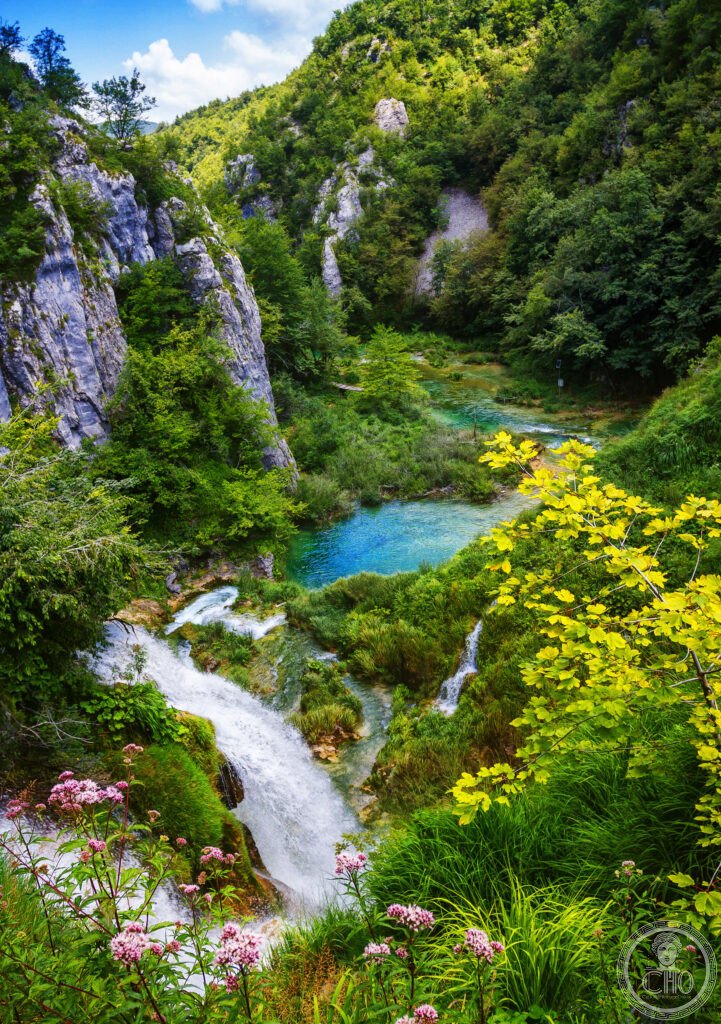
The most visually extraordinary national park in Europe and the geological wonder that explains why Croatians call their country the land of a thousand waterfalls — Plitvice Lakes, in the Dinaric karst of central Croatia, is a cascade of 16 turquoise and emerald lakes connected by 90 waterfalls and separated by living stone barriers of travertine that grow a centimetre every year.
At a glance
Plitvice Lakes National Park (UNESCO WHS 1979; placed on the Danger List 1992–1997 during the Croatian War of Independence when the park was occupied by Serbian forces and used as a military base — the most dramatically wartime-interrupted UNESCO heritage site in Europe; demining was completed by 2000; the park fully reopened with no physical damage to the lakes themselves (the most resilient natural heritage site in the Croatian war zone)); the park (296 km²; the 16 terraced lakes descend over a total vertical drop of 133 m (the most vertically efficient cascade-lake system in karst geography in Europe); the two zones (the Upper Lakes (Gornja Jezera; 12 of the 16 lakes; the forested highland plateau; the most biologically diverse zone: lynx, bear, wolf, and deer are present; the largest lake: Prošćansko jezero (68 ha; 37 m deep)); the Lower Lakes (Donja Jezera; 4 lakes including the most photographed sections; the Veliki Slap; the wooden boardwalks that pass directly above the turquoise water — the most photographed walking surface in any European national park)); the visitors (approximately 1.6 million per year — the most visited national park in Croatia; timed entry tickets and a mandatory daily visitor cap make this the most logistically complex national park visit in the former Yugoslavia).
Key facts
- The travertine barriers — living stone: the geological process that explains the Plitvice landscape — the tufa/travertine (the most important geological fact about Plitvice: the waterfalls and the lake terracing are not static; they are actively growing; the process (the calcite precipitation: the spring and river water flowing into the Plitvice valley carries dissolved calcium carbonate leached from the Dinaric limestone; when the water speeds up (at a waterfall) or contacts the algae and moss growing on submerged surfaces, the CO₂ escapes and the dissolved calcium carbonate precipitates as solid calcite crystals (travertine); these crystals accumulate on the algae and gradually build up into solid stone barriers — the most biologically mediated stone-formation process visible in any European national park; the growth rate: approximately 0.5–1 cm per year on the actively growing surfaces (the most precisely measured living stone growth rate in any European karst system)); the most extraordinary consequence: the lake boundaries are literally moving — the lake shores expand (where travertine is precipitating) and contract (where it is eroding) on a geological timescale visible within a single human lifetime; the 16 current lakes are the result of this process operating for approximately 8,000–12,000 years since the last glaciation))
- The waterfalls of the Lower Lakes: the most photographed cascade in Europe — the Lower Lakes (the most visited section of the park; accessible from Entrance 1 (the most photographed entry point: the wooden boardwalk section where the path runs over the water between lakes at the level of the waterfall crests; the single most-instagrammed landscape photo of Croatia after the Dubrovnik Old City walls; the view: standing on the boardwalk with the turquoise water of Jezero Kaluđerovac below and the Sastavci waterfalls (the most complex waterfall confluence in the park: 3–4 waterfalls join simultaneously in a single view) behind)); the Veliki Slap (the Great Waterfall; 78 m high; the tallest waterfall in Croatia; fed by the Plitvica River; the geological oddity: the Veliki Slap is not a travertine waterfall (it is a conventional rock-ledge waterfall) — the most frequently confused waterfall in the park (visitors assume the tallest waterfall is the travertine-formed one, but the most famous photo of Plitvice is actually the smaller travertine cascades, not the Veliki Slap); the Galovački Buk waterfall (the finest travertine waterfall in the park: 22 m high; 8 separate channels; the most complex travertine fan in the Upper Lakes))
- The 1991 war — the first shots of the Croatian War of Independence: the most politically significant recent history of any European national park — the Battle of Plitvice Lakes (31 March – 2 April 1991; the most important single battle of the first weeks of the Croatian War of Independence; the first armed confrontation between Croatian police and Serbian militias; the Croatian Ministry of the Interior sent special police units to reinforce the park staff (who had been blocked from entering by Serbian Krajina militia); the battle (the most consequential 48-hour engagement of the early Yugoslav wars: Croatian police officer Josip Jović was killed on 31 March 1991 — the first Croatian police officer killed in the conflict and arguably the first person to die in the Yugoslav Wars (the most debated “first casualty” designation in the historiography of the Yugoslav dissolution)); the Serbian forces occupied the park and expelled the Croatian staff; the park remained under Serbian Krajina control from April 1991 until August 1995 (Operation Storm); the UNESCO Danger List inscription (1992) was the most politically explicit Danger List inscription in the history of the World Heritage Convention: UNESCO stated explicitly that the danger was the armed conflict)
- Heritage: UNESCO World Heritage Site, Plitvice Lakes National Park, inscribed 1979
- GPS: 44.8804° N, 15.6175° E
History
Human settlement (the Plitvice Lakes area has been inhabited since at least the Bronze Age (c. 3000–1200 BCE; the Illyrian tribes of the Dinaric Alps; the most ancient continuous human presence in the Croatian hinterland); the Ottomans (the area was a frontier zone between the Ottoman and Habsburg empires from the 15th to 18th centuries; the most militarily contested landscape in the Croatian interior; the Vojna Krajina (Military Frontier) established by the Habsburgs in the 16th century to defend against Ottoman incursions used the Plitvice forested highlands as a defensive barrier); the modern national park (established 1949 by the Federal People’s Republic of Yugoslavia — the first national park established by communist Yugoslavia and the most important single conservation decision in Yugoslav natural heritage history; the park was expanded in 1997 after the war); the tourist development (the park received its first international visitors in the 1950s; by the 1980s it was the most visited tourist destination in Yugoslavia; the hotel complex (the Jezero, Bellevue, and Plitvice hotels — the most ambitious hotel construction in any Yugoslav national park; designed in the brutalist-organic style typical of 1960s Yugoslav tourist architecture)); the war (1991–1995; described in Key Facts); UNESCO WHS 1979 (Danger List 1992–1997, removed 1997 after Croatian reintegration of the area).
What you see
The Plitvice visit (the 2 entrances (Entrance 1: Lower Lakes; the most visited; all the famous boardwalk cascade photos; 4 route options (A–D; A is the shortest and most photographed); Entrance 2: Upper Lakes; the larger lakes; the forest zone; the boat across Kozjak Lake (the longest lake; the boat crossing is included in the ticket; the most pleasant single moment of the visit: the 10-minute electric boat crossing of the largest lake between the Upper and Lower systems with the mountains behind; silent; no engine noise; the most peaceful single boat ride in any European national park)); the best route (the full circuit: enter Entrance 2 → walk the Upper Lakes → boat across Kozjak → walk the Lower Lakes → boardwalk cascade section → Veliki Slap → walk back to Entrance 1 bus stop; allow 4–5h; the most complete single-day circuit of the park); the photography timing (the morning mist (the most atmospheric Plitvice condition: October–November mornings produce water vapour mist rising off the warmer lake surfaces (the most photographed meteorological effect at Plitvice; the water temperature in autumn (13–15°C) is warmer than the air, producing the mist); the midday light (the turquoise colour is most saturated in midday sun but the boardwalks are most crowded; arrive by 8am or after 4pm for the least crowded experience).
Practical information
- Getting there: Zagreb (the capital of Croatia; 130 km north; 2h by bus; multiple daily coach services from Zagreb Bus Station (Autobusni Kolodvor) to the park entrances (the most convenient approach for visitors based in Zagreb; the bus drops at both entrances); by car from Zagreb (the most flexible approach: A1 motorway (the most scenic section of the Croatian motorway network: the Gorski Kotar mountains and the Karst plateau)); Split (230 km south; 3h by bus; multiple daily coach services on the A1; the Split-Zagreb intercity route passes the nearest park town (Korenica) with a connection shuttle); Zadar (110 km south-west; 1h 30min by car; the most convenient Adriatic coast city for a Plitvice day trip); the entry ticket (the most important logistical fact for Plitvice: timed entry tickets are MANDATORY from May to September; tickets must be booked in advance online (at np-plitvicka-jezera.hr); the daily visitor cap (a maximum of approximately 10,000–15,000 visitors per day between the two entrances) means that same-day tickets are frequently unavailable in peak season (July–August); the most common visitor frustration at any Croatian national park)
- The Dalmatian Coast — Dubrovnik, Split, and the islands: the finest coastline in the Mediterranean — the Dalmatian Coast (the 1,800-km coastline of Croatia with 1,200 islands — the most indented coastline in the Mediterranean; the most island-dense coastal geography in Europe; the finest sailing waters in the Adriatic; the Bura wind (the most dangerous single weather event for sailing in the Adriatic: the Bura is a cold katabatic wind that drops from the Dinaric Alps to the sea in gusts exceeding 180 km/h — the most sudden and the most powerful wind in the Mediterranean); the island hopping (the most independently accessible island chain in Croatia: the car ferries (the most extensive domestic car-ferry network in the Mediterranean; Jadrolinija operates 50+ routes; the Split–Hvar–Korčula–Dubrovnik island route (the Split-to-Dubrovnik island hop: 2 days; the most satisfying slow-travel coastal route in the Adriatic; each island has a distinct character and wine-growing tradition)); Hvar (the sunniest island in Croatia; the most beautiful main harbour promenade in Dalmatia; the Stari Grad Plain (UNESCO WHS 2008: the 4th-century BCE Greek agricultural land division — the most completely preserved ancient Greek field system in the world; the stone walls have not moved since Alexander the Great was alive))
- Krka National Park and Šibenik: the finest Adriatic karst waterfall park — Krka (75 km west of the park on the Dalmatian coast near Šibenik; the other great Croatian waterfall park (the most frequently compared with Plitvice: Krka is smaller but warmer and you can swim in the pools — the most important single experiential difference between the two parks); the Skradinski Buk (the finest travertine waterfall cascade in Krka; 46 m total drop over 17 cascades; the swimming pool at the base of the main cascade (the only UNESCO-adjacent swimming pool in Croatia; closed as of 2021 due to ecological pressure); the Visovac Island (the Franciscan monastery on a tiny island in the middle of Visovac Lake — the most romantically situated monastery in Dalmatia); Šibenik (the most entirely Croatian city in Dalmatia (built without Roman or Venetian foundations — the only major Dalmatian city founded in the medieval Croatian kingdom rather than on Roman ruins); the Cathedral of St. James (UNESCO WHS 2000; the masterpiece of Juraj Dalmatinac (c. 1460; the finest stone mason in Dalmatia; the most technically innovative 15th-century stone building in the entire Adriatic: the barrel vault assembled without mortar by interlocking stone ribs — the most ambitious dry-stone vault in any Gothic cathedral))
Getting there
Zagreb 130 km (2h bus). Split 230 km (3h). Zadar 110 km (1h 30min). Timed-entry ticket MANDATORY May–Sep; book in advance at np-plitvicka-jezera.hr. Full circuit 4–5h. GPS: 44.8804, 15.6175.
Nearby
- Dubrovnik Old City (UNESCO WHS 1979) — 350 km south (4h 30min drive or 1h flight from Zagreb to Dubrovnik Airport); the finest walled medieval city in the Mediterranean and one of the most photographed urban skylines in the world — Dubrovnik (the marble-paved Stradun (the main pedestrian street; 292 m long; the Baroque limestone paving from 1667 (the Great Earthquake; the most destructive single event in Dubrovnik’s history); the City Walls (1.94 km continuous walkable rampart; the finest preserved medieval city walls in the Mediterranean; the rampart walk (the most popular tourist activity in Dubrovnik: 1h; the view from the Minčeta tower (the highest point; the Adriatic panorama and the Old City rooftops)); the Game of Thrones effect (Dubrovnik stood in for King’s Landing in the most watched fantasy television series in history; the most commercially consequential series of film locations in Croatian history: visitor numbers increased 10% year-on-year from 2012 to 2018))
- Krka National Park — 75 km west of the park via Zadar (described in Practical section); the essential Dalmatian waterfall companion to Plitvice; the combined itinerary: 2 nights Plitvice (full circuit + sunrise) + 1 night Šibenik + day trip to Krka + drive to Split for Adriatic island hopping
- Postojna Cave (Slovenia) and the Soča Valley — 280 km north-west (3h 30min drive via Zagreb and Ljubljana); the most impressive karstic cave system in Central Europe and the finest river gorge in the Alps — Postojna Cave (27 km of mapped passages — the most extensively mapped cave in Europe by accessible length; the cave train (the electric train that runs 5 km into the cave on its own underground railway — the most unique visitor transport in any European cave; the 50-minute underground tour; the Proteus anguinus (the olm; the cave-adapted salamander — the most famous aquatic cave dweller in Europe; blind, albino, living up to 100 years, going without food for up to 10 years — the most extreme physiological adaptation to underground life in any European vertebrate)); the Soča River (the most beautiful river in the Alps: the milky turquoise colour from glacial flour suspended in the water; the Triglav National Park; the WWI Isonzo Front battlefields)
Sources
- Wikipedia, Plitvice Lakes National Park; Travertine; Battle of Plitvice Lakes, accessed June 2026
- UNESCO, Plitvice Lakes National Park, WHS reference 98, inscribed 1979
- Croatian National Tourism Board, Plitvice Lakes official visitor guide, 2023 edition
Find it on the map
See this place and what’s around it →📷 Diventa un fotografo di Cultural Heritage Online
Condividi le tue foto dei luoghi: restano pubblicate con la tua firma come autore. Più vengono viste, più ti fai conoscere — e presto un concorso premierà le foto più apprezzate.
Accedi o registrati gratis per aggiungere una foto