

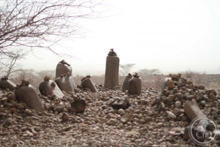
Two megalithic sites on the west bank of Lake Turkana — one a cairn cemetery, the other a field of standing stones aligned to stars — raise the possibility of the earliest known astronomical calendar in sub-Saharan Africa.
At a glance
On the west bank of Lake Turkana in the remote Turkana County of northwestern Kenya, two sites known collectively as Namoratunga preserve an unusual and debated megalithic complex. Namoratunga I, on the south shore of Lake Turkana, is a cemetery of approximately 19 cairns with associated standing stones, dated to approximately 300 BC. Namoratunga II, approximately 60 km to the northwest, consists of 19 basalt pillars in alignments that American archaeoastronomer B.M. Lynch proposed in 1978 correlate with a stellar calendar still used by the Cushitic-speaking Borana people of Ethiopia and Kenya. If correct, Namoratunga II would be the earliest astronomical calendar device in sub-Saharan Africa.
Key facts
- Location: West bank of Lake Turkana, Turkana County, northwestern Kenya
- Two sites: Namoratunga I (cairn cemetery, south shore) and Namoratunga II (standing stone alignments, 60 km northwest)
- Date: c. 300 BC (Late Stone Age/early Iron Age, Cushitic culture)
- The stellar claim: 19 basalt pillars at Namoratunga II align to seven stars (Pleiades, Triangulum, Bellatrix, Aldebaran, Orions Belt, Saiph, Sirius) matching the Borana 12-month lunar calendar
- If confirmed: Earliest known astronomical calendar device in sub-Saharan Africa, predating written astronomical records in the region by ~1,500 years
- Contested: Subsequent scholars argue the alignments may not be statistically significant
- Cultural context: Associated with a pre-Nilotic Cushitic population present before the Turkana people arrived
History
The Namoratunga sites were first brought to international archaeological attention by American researchers in the 1970s. Namoratunga I — the cemetery on the south shore of Lake Turkana — had been known to regional archaeologists as a cairn cemetery associated with a pre-pastoral Cushitic population, dated by associated ceramics to approximately 300 BC. It represents a significant regional mortuary tradition: the practice of erecting standing stone cairns above individual burials, with parallels as far north as the Aksumite heartland of Ethiopia.
In 1978, archaeoastronomer B.M. Lynch published a provocative analysis of Namoratunga II, the standing stone site approximately 60 km to the northwest. Lynch identified alignments between 19 basalt pillars and seven astronomical targets — Triangulum, the Pleiades, Bellatrix, Aldebaran, Orions Belt, Saiph, and Sirius — that corresponded to the seven stars used by the Cushitic-speaking Borana people of Ethiopia and Kenya to regulate a complex 12-month lunar calendar known as the borana calendar. Lynchs thesis was that Namoratunga II was a physical encoding of this calendar system in stone approximately 2,300 years ago — making it the earliest documented astronomical calendar instrument in sub-Saharan Africa.
The claim has been energetically contested. Subsequent scholars, including C.T. Doyle and others, have argued that the stone alignments are not statistically distinguishable from random placement and that the correspondence Lynch identified may be coincidental. The debate remains unresolved. What is not disputed is the antiquity of the Borana calendar system and the deep cultural continuity between the pre-pastoral Cushitic populations of the Lake Turkana basin and the living Borana communities of today.
What you see
Namoratunga I is a cemetery site on the south shore of Lake Turkana. The cairns — low stone mounds piled over individual burials — are accompanied by upright standing stones, some carved, others plain. The site is a windswept, open landscape at the edge of the lake, with the volcanic terrain of Turkana County surrounding it. The standing stones are modest in scale but significant in the evidence they provide of a pre-pastoral population with organised mortuary customs.
Namoratunga II is the more dramatic of the two sites: 19 basalt pillars erect in a remote area of the Turkana basin, their alignments the subject of the astronomical hypothesis. The pillars stand in an arid, sparsely vegetated landscape with Lake Turkana visible in the distance. Access to both sites requires a 4WD vehicle and significant logistical preparation; they are among the most remote archaeological sites in Kenya. The landscape itself — vast, volcanic, and practically empty of permanent habitation — provides the dominant impression.
Practical information
- Access: Remote — requires 4WD and considerable logistical preparation; typically visited as part of an organised Lake Turkana expedition
- Base: Lodwar (the Turkana County capital) or Loyangalani on the east shore of Lake Turkana, for those circumnavigating the lake
- Infrastructure: Minimal; the sites are not developed for tourism and have no visitor facilities
- Security: Check current conditions in Turkana County before travel; the region is remote and pastoral tribal tensions have historically affected access
- Best time: October–March (northern dry season) for most reliable road conditions
Getting there
The Namoratunga sites are in Turkana County, northwestern Kenya, approximately 900 km from Nairobi. The main access route is via Kitale and Lodwar on the B4 highway, or via Eldoret–Marich Pass–Lodwar. From Lodwar, the sites require 4WD travel on dirt tracks. Flights serve Lodwar from Nairobi (Wilson Airport) via several domestic carriers. The sites are most commonly visited as part of multi-day expeditions to Lake Turkana, often including the jade sea itself, Sibiloi National Park, and other palaeontological sites of the Turkana basin.
Nearby
- Lake Turkana — the worlds largest desert lake, a UNESCO World Heritage Site; the extraordinary jade-green waters are a landmark in their own right
- Sibiloi National Park — UNESCO WHS on the east shore of Lake Turkana; home to some of the most important palaeontological sites in the world, including discoveries by Richard Leakey
- Lodwar — Turkana County capital; base for Turkana basin expeditions
Sources
- Lynch, B.M. and Robbins, L.H., “Namoratunga: The First Archaeoastronomical Evidence in Sub-Saharan Africa”, Science 200 (1978): 766–768
- Doyle, C.T., “A Critical Examination of the Namoratunga Archaeoastronomy Site”, Azania, 1986
- Hildebrand, E.A., et al., “A Pastoral Neolithic site in the Lake Turkana basin”, Journal of African Archaeology, 2010
- Gifford-Gonzalez, D. and Kimengich, J., “Faunal Evidence for Early Cattle Keeping in the Central Rift Valley”, in From Hunters to Farmers, ed. Clark and Brandt, 1984
- Asher-Greve, Julia M., “African Astronomy”, in Encyclopaedia of the History of Science, Technology, and Medicine in Non-Western Cultures, Springer, 2016
Find it on the map
See this place and what’s around it →📷 Become a Cultural Heritage Online photographer
Share your photos of places: they stay published under your name as the author. The more they're seen, the more you get noticed — and soon a contest will reward the most appreciated photos.
Log in or sign up free to add a photo