Nabta Playa
A prehistoric lake bed 100 km west of Abu Simbel where nomadic Saharan pastoralists built the world’s oldest known astronomically aligned monument — a stone calendar circle older than Stonehenge by a thousand years.
At a Glance
Nabta Playa is a dry lake basin in the Egyptian Western Desert, approximately 100 km west of Abu Simbel and 800 km from the Nile, in the extreme south of Egypt near the Sudanese border. Between approximately 6700 and 3400 BC, during periods when Saharan monsoons extended further north, the area was seasonally green and inhabited by nomadic cattle-herding peoples. These people left one of the most extraordinary prehistoric sites on earth: a stone circle aligned to the summer solstice that predates Stonehenge by roughly 1,000 years, buried megalithic slabs arranged in astronomically significant patterns, and what may be the oldest known cattle cult in the world.
Discovery
In 1973, archaeologist Fred Wendorf of Southern Methodist University was travelling through the Egyptian Sahara when his vehicle became stuck in a sandstorm near a flat desert basin called Nabta Playa. As he waited, he noticed pottery sherds and cattle bones on the desert floor — materials that could not have been deposited in the hyper-arid conditions of recent centuries. He had found evidence of a vanished wet period in the Sahara, now called the African Humid Period or Green Sahara. Wendorf returned repeatedly, and over two decades of excavation his team uncovered one of the most significant Neolithic sites ever found.
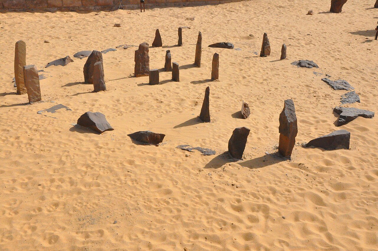
The Stone Circle Calendar
The most celebrated feature of Nabta Playa is a stone circle approximately 4 metres in diameter, composed of flat slabs set upright in the desert floor. Astrophysicist J. McKim Malville, who first analysed the site’s alignments in the 1990s and published his findings in 1998, determined that specific pairs of stones within the circle align precisely to the summer solstice sunrise — the day when the monsoon rains historically arrived, making the solstice the most critical event in the pastoral calendar. The circle thus functioned as a calendar for predicting and announcing the life-sustaining rains. This alignment, dated to approximately 4500 BC in the circle’s current form (though the site was occupied far earlier), makes Nabta Playa’s calendar the oldest known astronomically aligned megalithic monument in the world. Stonehenge’s main construction phase dates to c. 3000–2500 BC.
Megalithic Alignments and the Stars of Orion
Beyond the stone circle, Wendorf’s team found a series of large upright stone slabs and stone-capped tumuli (burial cairns) arranged in lines across the playa floor. Malville proposed that these megalithic alignments mirror specific stars in the constellation Orion — particularly the belt stars, which rise near the summer solstice at this latitude — though this interpretation remains debated among archaeoastronomers. Whether or not the stellar interpretation is correct, the scale and deliberateness of the arrangement is extraordinary: megaliths weighing several tonnes were transported and positioned according to a planned spatial scheme covering several square kilometres.
The Cattle Burials
One of Nabta Playa’s most surprising finds was a series of cattle burials in mudbrick chambers. Cattle bones — apparently of whole animals — were deliberately interred in constructed enclosures, suggesting cattle held ritual or symbolic significance for the Nabta Playa people. These are among the oldest known examples of deliberate cattle burial anywhere in the world, dated to c. 5000 BC, predating Egyptian cattle iconography by approximately 2,000 years. The archaeologists proposed that the practice represented an early form of cattle veneration that may have been ancestral to the sacred cattle traditions of pharaonic Egypt — a hypothesis that remains speculative but compelling.
Archaeological and Astronomical Significance
Nabta Playa overturned several assumptions about Saharan prehistory and the origins of Egyptian civilisation. The site demonstrated that: (1) complex organisational behaviour and astronomical knowledge developed independently in nomadic pastoral societies, not just in settled agricultural ones; (2) the Sahara during the Green Sahara period was the setting for sophisticated social and ceremonial life; (3) the cattle-herding peoples who later migrated east as the Sahara dried (c. 3400 BC) may have brought cattle veneration and possibly astronomical traditions into the Nile Valley, contributing to the cultural foundations of ancient Egypt.
Current State and Access
The stone circle was removed from the site for study and subsequently reassembled near its original location on the playa. Several of the large buried megaliths are now displayed in the Nubian Museum in Aswan. The site itself is extremely remote and currently inaccessible to casual visitors: reaching Nabta Playa requires a multi-day desert expedition from Abu Simbel or Aswan with military permits (the area is near the Libyan and Sudanese borders). Archaeological expeditions continue under Egyptian and international permits. The site is not on any standard tourist itinerary.
Practical Information
Nabta Playa cannot currently be visited without military permits and specialised desert expedition logistics. The nearest city is Aswan (approximately 800 km by road). The Nubian Museum in Aswan displays some of the megalithic finds. For those interested in the site’s context, Abu Simbel (100 km east of Nabta) is reachable by road or direct flight from Aswan and provides a logical base for any serious expedition. Academic teams wishing to visit should apply through Egypt’s Ministry of Antiquities (Supreme Council of Antiquities).
Getting There
Aswan is the practical entry point: fly from Cairo or Luxor to Aswan International Airport. From Aswan, Abu Simbel is 280 km south by road or 50 minutes by direct charter flight. Nabta Playa lies a further 100 km west into the desert from Abu Simbel, requiring 4WD convoy, GPS navigation, desert provisions, and military clearance. No commercial tours operate to the site at present.
Nearby
- Abu Simbel — 100 km east; UNESCO-listed Ramesses II temples, relocated in 1968 to save them from Lake Nasser
- Nubian Museum, Aswan — 800 km north; displays several Nabta Playa megaliths and the finest overview of Nubian and Saharan prehistory
- Gebel Uweinat — 500 km west; rock art of extraordinary quality dating to the Green Sahara period
Sources
- Wikipedia: Nabta Playa
- J. McKim Malville et al., “Megaliths and Neolithic astronomy in southern Egypt,” Nature 392 (1998), pp. 488–491
- Fred Wendorf & Romuald Schild, Holocene Settlement of the Egyptian Sahara, Vol. 1 (Kluwer/Plenum, 2001)
- Thomas G. Brophy & Paul A. Rosen, “Satellite imagery measures of the astronomically aligned megaliths at Nabta Playa,” Mediterranean Archaeology and Archaeometry 5:1 (2005)
Find it on the map
See this place and what’s around it →📷 Diventa un fotografo di Cultural Heritage Online
Condividi le tue foto dei luoghi: restano pubblicate con la tua firma come autore. Più vengono viste, più ti fai conoscere — e presto un concorso premierà le foto più apprezzate.
Accedi o registrati gratis per aggiungere una foto