Mrauk-U
The forgotten Buddhist fortress-city of the Mrauk-U Kingdom — once a Bay of Bengal trading power whose Portuguese and Dutch visitors compared it to Amsterdam — lost in Rakhine jungle since 1785.
At a glance
Mrauk-U was the capital of the Mrauk-U Kingdom from 1430 to 1785, controlling Bay of Bengal trade between Bengal and Southeast Asia at its height. Its temples are fortress-temples unlike anything else in Buddhist architecture: massive thick-walled structures with narrow vaulted corridors lined with thousands of carved Buddha images, designed as both sacred space and defensive fortification. Today hundreds of temples and stupas survive amid rice paddies and jungle hills in Rakhine State, accessible only with difficulty — which has preserved them from mass tourism.
Key facts
- Period: Mrauk-U Kingdom, 1430–1785 AD
- Peak population: c. 160,000 — larger than most European capitals of the era
- Location: Rakhine State, western Myanmar, river delta country
- Architecture type: Fortress-temples with barrel-vaulted galleries, unique in Southeast Asian Buddhism
- Key monument: Shitthaung Temple (1535) — “Temple of 80,000 Buddha Images”
- Fate: Sacked by Burmese king Bodawpaya in 1785; never reoccupied as capital
- Access: Permit required; reached by boat up the Kaladan River from Sittwe
History
Mrauk-U was founded in 1430 by King Minsawmon after he reclaimed the Arakan throne with Bengali military support, establishing a kingdom that would endure for 355 years. The city sat at the intersection of Bay of Bengal trade routes connecting Bengal, Persia, China, and Southeast Asia — Mrauk-U merchants controlled river tolls and sold Bengali rice to Persia and China. At its peak the city had a cosmopolitan character unusual for the region: Portuguese adventurers served as mercenaries in the royal army, Dutch and Bengali traders maintained permanent warehouses, and Mughal envoys arrived bearing gifts. Successive Portuguese, Dutch, and Mughal visitors compared the city in size and wealth to Amsterdam and London.
The kingdom maintained independence for over three centuries through a combination of defensive geography (the city was surrounded by an elaborate system of canals, lakes, and hills that made direct assault nearly impossible), diplomatic skill, and control of the rice trade. It absorbed repeated Burmese and Mughal pressure. The end came in 1785, when the Burmese king Bodawpaya invaded, captured the city without significant resistance, executed or deported the royal family, and removed the kingdom’s sacred Buddha image (the Mahamuni, now in Mandalay) to symbolise the transfer of spiritual sovereignty. The city was never reoccupied as a capital, and its population dispersed — leaving the temples in a state of romantic ruin amid working Rakhine paddy fields.
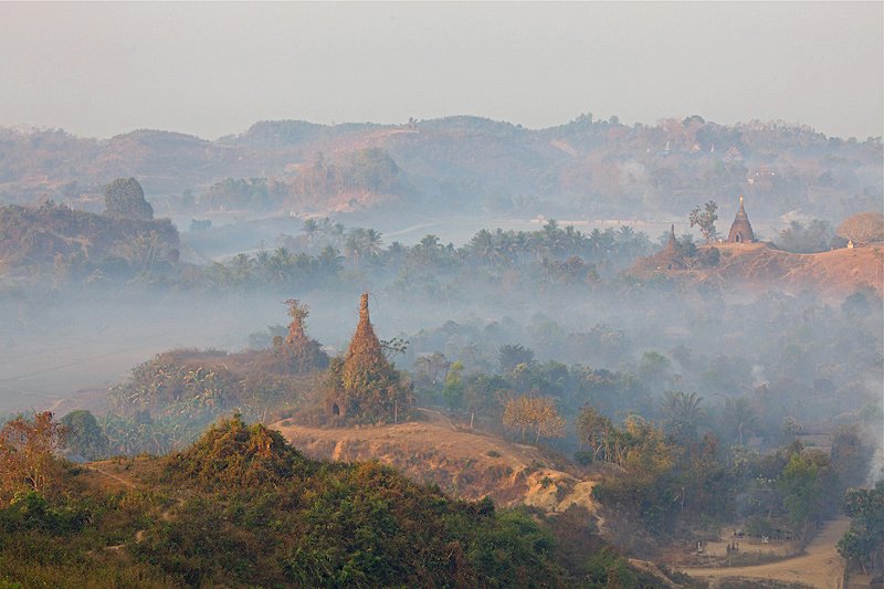
What you see
The temple architecture of Mrauk-U is the most distinctive aspect of the site. Unlike the open-sided pagodas of Bagan (which reflect Indian subcontinent influence), Mrauk-U temples are fortress-temples: massive stone structures with thick outer walls, narrow entrance corridors, and interior galleries with corbelled or barrel-vaulted ceilings lit by small apertures cut through the walls. The Shitthaung Temple (1535), built by King Minbin to celebrate his defeat of the Portuguese at Chittagong, has a central tower surrounded by three concentric corridors, each wall surface covered with carved sandstone niches housing Buddha images — 80,000 individual Buddhas in total, the repetition creating a hypnotic, cave-like atmosphere completely unlike anything else in Buddhist art. The Htukkanthein temple (1571) has an extraordinary corbelled stone ceiling in its central corridor and stone reliefs depicting warriors, musicians, and court scenes from Mrauk-U’s cosmopolitan golden age.
The broader landscape is as striking as the individual monuments: stupas and temple spires rise from forested hills above the river, with paddy fields between them still cultivated by Rakhine farmers as they have been for centuries. The combination of working agricultural landscape and slowly-ruined medieval city gives Mrauk-U a visual quality closer to Angkor in the early 20th century — before restoration — than to any manicured heritage site today.
Trade empire and cosmopolitan capital
The standard image of pre-colonial Southeast Asian kingdoms as isolated local polities does not fit Mrauk-U. At its height in the 16th and 17th centuries, the city was a node in Indian Ocean trade networks with direct commercial and diplomatic connections to Bengal, Persia, China, Portugal, and the Dutch Republic. The Arakanese court minted silver coins (the ‘tanka’) modelled on Mughal coinage — an acknowledgement of economic realities. Portuguese mercenaries served in the Mrauk-U army and one Portuguese adventurer, Filipe de Brito e Nicote, briefly ruled the port of Thanlyin as a semi-independent tributary under Mrauk-U patronage before being captured and executed in 1613. The kingdom was also a significant centre of Bengali literature: the Bengali poet Alaol, writing at the Mrauk-U court in the 17th century, produced works that are now considered among the masterpieces of early modern Bengali literature.
Practical information
- Permits: Foreign visitors require a permit to visit Mrauk-U (conditions change; verify current requirements before travelling)
- Access: Fly to Sittwe from Yangon or Mandalay; then 3–5 hours by boat up the Kaladan River to Mrauk-U town
- Accommodation: Basic guesthouses in Mrauk-U town; some boutique lodges have opened in recent years
- Best time: November–February (dry season); avoid monsoon May–September
- Duration: Minimum 2–3 days to see the main temples; 4–5 days for outlying sites
- Note: The political situation in Rakhine State is complex; check current travel advisories
Getting there
Mrauk-U is reached via Sittwe, the capital of Rakhine State, which has a domestic airport with connections to Yangon and Mandalay. From Sittwe, the only practical route to Mrauk-U is by boat up the Kaladan River — a journey of 3–5 hours depending on vessel and water level. There is no paved road connection. The remoteness has historically been a major barrier to visitor numbers, but it has also preserved the site from the infrastructure damage that accompanies mass tourism.
Nearby
- Sittwe — Rakhine State capital, 3–5 hours by boat; departure point for Mrauk-U
- Mahamuni Pagoda, Mandalay — houses the sacred Mahamuni Buddha image removed from Mrauk-U in 1785
- Bagan — Myanmar’s other great temple city, different architectural tradition; approximately 2 days’ travel
Sources
Find it on the map
See this place and what’s around it →📷 Diventa un fotografo di Cultural Heritage Online
Condividi le tue foto dei luoghi: restano pubblicate con la tua firma come autore. Più vengono viste, più ti fai conoscere — e presto un concorso premierà le foto più apprezzate.
Accedi o registrati gratis per aggiungere una foto