Meteora
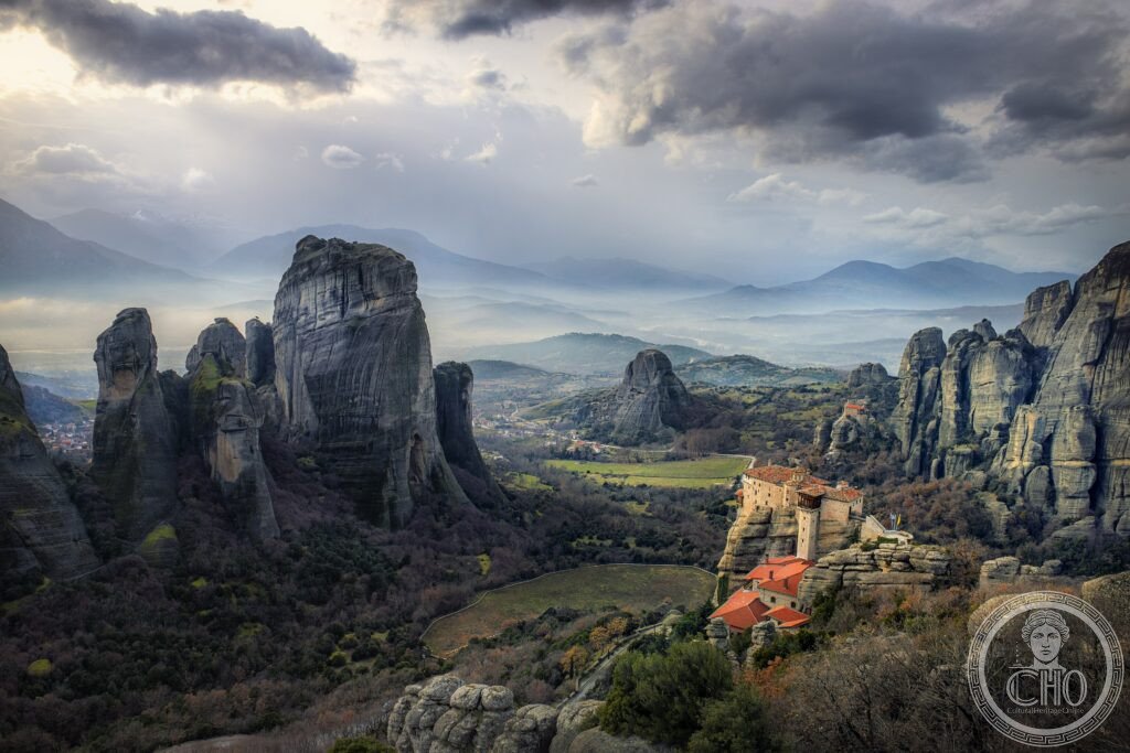
The most extraordinary monastic landscape in the world — Meteora (“suspended in the air”) in Thessaly, Greece, is a complex of Eastern Orthodox monasteries perched on sandstone rock pillars up to 400 metres high that rise abruptly from the flat agricultural plain; the monasteries were built from the 14th century onward in locations so inaccessible that goods had to be hauled up in nets by hand-cranked windlasses, in deliberate defiance of worldly accessibility.
At a glance
The Meteora (UNESCO WHS 1988; one of the few sites inscribed for both its cultural and natural values simultaneously; the cultural value: the 6 surviving monasteries with their Byzantine art and their extraordinary ascetic history; the natural value: the unique rock formations) is located in central Greece, near the towns of Kalambaka and Kastraki, at the western edge of the Thessaly basin; the sandstone pillars were formed by a combination of geological processes over approximately 60 million years — the rock was originally deposited as sediment at the delta of a large river system; tectonic forces lifted the region, and millions of years of erosion by rain, wind, and small streams have removed the softer surrounding rock, leaving the harder conglomerate pillars standing; the 6 open monasteries are: the Great Meteoron (the largest; founded 1344 by the monk Athanasios Koinovitis; the most important collection of Byzantine art outside Constantinople), the Varlaam (founded 1541; notable for the Chapel of All Saints and the net windlass still in use), the Roussanou (visually the most dramatic — built directly on the edge of a pillar with sheer drops on all sides; now a nunnery), the Agios Nikolaos Anapafsas (small; the best preserved Byzantine frescos), the Agios Stefanos (the most accessible — connected to the road by a bridge; now a nunnery), and the Holy Trinity (the most remote and most dramatically situated; accessed by 140 carved rock steps).
Key facts
- The history of the monasteries: among the most extreme locations chosen for Christian monasticism in the world — the hermit monks of Thessaly had lived in the rock cavities and ledges of the Meteora since the 9th century AD; the first permanent monastic community was established by the monk Athanasios Koinovitis from Mount Athos, who reached the Great Meteoron rock in 1344 and established a community there; the golden age of Meteoran monasticism was the 15th and 16th centuries, when 24 monasteries were inhabited and the area was an important centre of Eastern Orthodox learning and Byzantine art; all construction had to be done using materials hauled up by ropes, nets, and later windlasses (the windlass is a hand-cranked mechanical device for hoisting; the nets still serve for goods supply to the Varlaam monastery as of 2026; monks are lowered in the net for maintenance on the cliff faces); at the peak, approximately 2,000 monks lived in the Meteora; by the mid-20th century, only 4 monks remained; the revival of monastic life at Meteora began in the 1970s and the 6 monasteries now have enough monks and nuns to continue their communities
- The Byzantine art: the most important collection of Post-Byzantine religious painting in Greece — the Meteoran monasteries contain extensive cycles of Byzantine and Post-Byzantine frescos (painted from the 14th to the 17th centuries; the styles range from the refined Late Byzantine manner of the 14th century — influenced by the Palaeologan Renaissance — to the more expressive Cretan School style of the 16th century); the most significant paintings are in the Great Meteoron (the main church, the Catholicon of the Transfiguration, has frescos by Georgios and Frangos Katelanos, 1552; the Martyrs Hall has one of the most vivid cycles of Christian martyr scenes in Greek art) and in the Varlaam monastery (the Catholicon of All Saints has frescos by Frangos Katelanos, 1548; the colours are exceptionally well-preserved)
- The rock formations: why the pillars exist — the Meteora pillars are composed of a grey-brown conglomerate (a rock made of rounded pebbles and boulders cemented together by a sandstone matrix; the pebbles were deposited at the mouth of a large river approximately 60 million years ago); the pillars rose as the surrounding softer limestone was dissolved by rainwater and carried away; the current height of the pillars represents millions of years of differential erosion; the process is still ongoing — the pillars continue to erode, but very slowly (archaeologists and geologists monitor them for stability and some sections have been reinforced); the characteristic overhanging caps on many pillars (where the conglomerate is denser and harder than the rock below) are the visual signature of Meteoran geology
- Heritage: UNESCO World Heritage Site, Meteora, inscribed 1988 (combined cultural and natural)
- GPS: 39.7217° N, 21.6306° E
History
Hermit monks in the Thessaly rock cavities from the 9th century AD; Athanasios Koinovitis founded the Great Meteoron in 1344; the golden age of the monasteries: 15th–16th centuries (24 monasteries; 2,000 monks; extensive Byzantine art); the Ottoman occupation of Thessaly from 1393 ironically protected the monasteries — the Ottomans were generally tolerant of Christian institutions that paid taxes and did not foment rebellion; the monasteries were looted during the German occupation in 1943 (the Germans took books, manuscripts, and small icons); population decline in the 20th century reduced occupancy to 4 monks by the 1950s; the UNESCO WHS designation in 1988 and the James Bond film “For Your Eyes Only” (1981, which showed the monasteries to a worldwide audience) both contributed to the revival; the current 6 open monasteries have stabilised their communities.
What you see
The monasteries are connected by a paved road (opened 1960; until the road was built, access was only by rope ladder or carved rock steps; the road made the site accessible to mass tourism and also made it financially viable for the monks to stay; before the road, goods arrived in nets hoisted by windlasses — the windlass at Varlaam (the original mechanism; the net is 3.5 metres in diameter; still used for goods) is open to visitors); each monastery has its own character: the Great Meteoron (the largest complex; the ossuary with monks’ skulls arranged in rows; the Catholicon with the Katelanos frescos; the refectory turned museum), the Varlaam (the most complete surviving monastic complex; the windlass and net; the Chapel of All Saints), the Roussanou (the most dramatic position — on the very edge of the pillar with a drop of 200+ metres on three sides; now a nunnery; small but stunning), the Holy Trinity (the most remote; accessed from the road by a 140-step stairway carved in the rock; the view from the terrace is the best single photograph point in the Meteora).
Practical information
- Getting there: the nearest town is Kalambaka (population approximately 12,000; at the foot of the rocks; abundant accommodation); Kalambaka is 355 km north-west of Athens (4h by road; or 4h 30 min by InterCity train from Athens Larissa station, changing at Palaiofarsalos; the most atmospheric approach is the 2h mountain train from Palaiofarsalos to Kalambaka through the Pindus Mountain foothills); from Thessaloniki: 220 km (3h by road); the monasteries are 4 km from Kalambaka town centre by the ring road that circles the rock formations (accessible by local bus, taxi, bicycle rental, or car)
- Visiting rules: all 6 monasteries require modest dress (covered shoulders, covered knees; sarongs are available for loan at the entrance of most monasteries); each monastery charges a small entry fee (approximately EUR 3 per monastery); the monasteries are not all open on the same day (the schedule rotates to allow monasteries to close for maintenance; a schedule is available at the Kalambaka tourist information; generally, 4–5 monasteries are open on any given day); the best time to visit is in the morning (9–11am; the light is soft; the tour buses have not yet arrived from Athens; in the afternoon, the tour buses from Athens and Thessaloniki, which arrive at 1–2pm, fill the narrow access roads and the monastery courtyards); sunrise and sunset from the Kastraki viewpoints (without entering the monasteries) are the most atmospheric times of day
- Hiking: the Meteora is increasingly popular for hiking and climbing (a network of trails connects the monastery road with the older paths that the monks used before the road was built; several via ferrata routes have been established on the rock faces for climbers; day hikes from Kalambaka to the monastery plateau via the old monk paths take 2–3 hours and avoid the road entirely)
Getting there
Kalambaka town at the foot of the rocks. Train from Athens (4h 30 min) or Thessaloniki (3h by road). GPS: 39.7217, 21.6306.
Nearby
- Delphi — 200 km south of Meteora (3h by road); the most important sanctuary in ancient Greece and the centre of the known world — Delphi (the sanctuary of Apollo; the most important oracle site in the ancient Mediterranean world; “Know yourself” and “Nothing in excess” were inscribed at the entrance; the Oracle of Delphi (the Pythia; a priestess who inhaled volcanic gases rising from a fissure in the rock and gave prophecies that were interpreted by the priests; the gases were identified by geological analysis in 2001 as ethylene, a sweet-smelling hydrocarbon that induces a trance-like state at low concentrations); the Sacred Way (the ascending path through the sanctuary; flanked by the treasuries built by the Greek city-states to house their dedications); the Temple of Apollo (the centre of the oracle; only the foundations and 6 columns stand); the Theatre (5,000 seats; the view from the upper seats over the Gulf of Corinth is one of the most spectacular theatrical backdrops in Greece); the Stadium (the Pythian Games, held every 4 years like the Olympics, included athletic competitions here); UNESCO WHS 1987)
- Mount Olympus and Litochoro — 200 km north-east of Meteora (3h by road); the highest mountain in Greece and the home of the gods — Mount Olympus (2,917 m; the national park; UNESCO Biosphere Reserve; the mythological home of Zeus and the Olympian gods in Greek religion; the highest summit, Mytikas, can be climbed by fit hikers in 2 days from Litochoro (the mountain village gateway at 303 m; 20 km from the coast); the ascent from Litochoro to the Prionia trailhead (3h walk or 1h by car) and from Prionia to the Spilios Agapitos refuge hut at 2,100 m (3h walk) and from the hut to the Mytikas summit (4h) constitutes one of the great mountain experiences in the Mediterranean; the summit requires no technical equipment in summer)
- Thessaloniki — 220 km north-east of Meteora (3h by road); the second-largest city in Greece and the most important Byzantine city in the world outside Constantinople — Thessaloniki (population 820,000; UNESCO WHS 1988 for its Early Christian and Byzantine monuments — 15 monuments inscribed as a group; the Rotunda (a 4th-century Roman mausoleum converted to a church and then to an Ottoman mosque; the gold mosaics in the dome are among the finest surviving early Byzantine mosaics), the White Tower (the most recognisable monument of Thessaloniki; a 15th-century Ottoman sea tower; the symbol of the city), the Arch of Galerius (a triumphal arch from 305 AD celebrating the Roman emperor’s victory over Persia; the Rotunda and the arch are part of the same late Roman imperial complex); Thessaloniki has the best food and nightlife in Greece outside Athens)
Sources
- Wikipedia, Meteora; Great Meteoron Monastery; Athanasios of Meteora, accessed June 2026
- UNESCO, Meteora, WHS reference 455, inscribed 1988
- Elizabeth Boleman-Herring, The Monastery of Varlaam and the Great Meteoron, Toubi’s Press, Athens, 1998
Find it on the map
See this place and what’s around it →📷 Diventa un fotografo di Cultural Heritage Online
Condividi le tue foto dei luoghi: restano pubblicate con la tua firma come autore. Più vengono viste, più ti fai conoscere — e presto un concorso premierà le foto più apprezzate.
Accedi o registrati gratis per aggiungere una fotoDo you manage this place?
This page is read by travellers and heritage enthusiasts who find it on Google. Keep it accurate — and make it work for you. Free for non-profit heritage institutions.