
For two centuries Merv was capital of the Seljuk Empire and one of the great cities of the Silk Road, its population among the largest on Earth. In 1221 the Mongols destroyed it almost completely. What survives is a five-kilometre landscape of ruined cities, dominated by the turquoise dome of Sultan Sanjar’s tomb.
At a glance
Ancient Merv lies in an oasis fed by the Murghab River, where the Karakum Desert meets the edge of the Iranian plateau. Its position at the crossing of routes from China, India, Persia and the Mediterranean made it one of the principal stations of the Silk Road for well over a thousand years. The name Merv, from the Old Persian Margu, gave rise to the Latin Margiana and the Greek Margiane.
The site protected as Ancient Merv is not a single city but five, built one after another over roughly five kilometres and never fully abandoned: Erk Kala, a circular Achaemenid citadel of the 6th century BCE; Gyaur Kala, spanning the Hellenistic to early Islamic periods; Sultan Kala, the Seljuk capital and the largest of the five; Abdullakhan Kala, of the Timurid era and later; and Bayramali Kala, from the 19th century.
Key facts
- Mausoleum of Sultan Sanjar: built around 1157, roughly 38 metres high, regarded as the most important surviving Seljuk monument. Its inner dome collapsed long ago, but the turquoise outer dome remains visible for miles across the desert.
- The Mongol massacre of 1221: after a short siege, Tolui Khan’s forces killed the population of Merv despite a promise of safe conduct. Contemporary chronicles report a death toll in the hundreds of thousands, a scale that shocked even the Mongols’ own commanders, and the city’s irrigation system was destroyed with it.
- Sultan Sanjar: the last Great Sultan of the Seljuk Empire, who ruled from Merv between 1118 and 1157, when the empire stretched from Anatolia to Afghanistan.
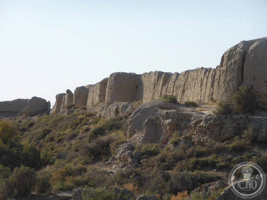
- The Greater and Lesser Kyz Kala: Sasanian or early Islamic strongholds of the 6th to 7th centuries, their corrugated mud-brick walls standing around 15 metres high. Their exact function, whether fortified residence, caravanserai or administrative building, remains uncertain.
- Coordinates: 37.6456° N, 62.1934° E.
History
Alexander the Great passed through the Merv oasis in 329 BCE during his Central Asian campaign and is said to have refounded the settlement as Alexandria Margiana, one of the many colonial cities bearing his name that he established in the east. The Seleucid king Antiochus I later strengthened its walls; the historian Strabo recorded fortifications stretching for hundreds of kilometres around the agricultural hinterland.
Merv reached its greatest extent under the Seljuk sultans, when it served as the empire’s capital and the chief transshipment point on the Silk Road between China, India and the Mediterranean. The city supported multiple caravanserais, a renowned library, a paper-making industry using technology brought from China, and numerous mosques and madrasas. That prosperity ended abruptly in 1221, when the Mongol destruction left the city too damaged to be rebuilt on its former scale.
What you see
Today the site is a wide, largely open archaeological landscape on the edge of the modern town of Mary. The Mausoleum of Sultan Sanjar, restored in the 1990s, is the most visible landmark from the approach road, and its interior shows something of the original painted plaster decoration. The Greater Kyz Kala, with its distinctive ribbed mud-brick walls, is the most photographed of the ruins, particularly in low afternoon light. The circular citadel of Erk Kala offers the highest ground on the site and the clearest overview of the whole five-kilometre complex.
Practical information
- Access: the ruins form part of the State Historical and Cultural Park “Ancient Merv”; a local guide fluent in Russian, English or Turkmen is recommended and widely available.
- Visa: a Turkmenistan visa is required for entry; an e-visa is available to most nationalities, and travellers should check current requirements and costs through official channels before travel.
- Time needed: the main monuments are spread over a wide area, so a half-day is a reasonable minimum to see the principal sites properly.
- Accommodation: most visitors base themselves in the nearby town of Mary, where hotel booking ahead is advisable.
Getting there
Merv lies a short distance from the town of Mary, the provincial capital, which has an airport with domestic flights connecting to Ashgabat. Ashgabat itself has international connections through several regional hubs. From Mary, the site is reached by road; current transport options and any associated costs are best confirmed locally or through the park’s official channels.
Nearby
- Gonur Depe — around 70 km north; the Bronze Age capital of the Bactria-Margiana Archaeological Complex, excavated by the archaeologist Viktor Sarianidi, with a large temple precinct and royal burial mounds dating to the third and second millennia BCE.
- Ashgabat — around 350 km northwest; the modern capital of Turkmenistan, notable for its extensive use of white marble cladding across entire districts.
Sources
- Wikipedia, Ancient Merv
- Wikipedia, Sultan Sanjar
- Wikipedia, Seljuk Empire
- UNESCO, State Historical and Cultural Park “Ancient Merv”, WHS reference 886
Find it on the map
See this place and what’s around it →📷 Become a Cultural Heritage Online photographer
Share your photos of places: they stay published under your name as the author. The more they're seen, the more you get noticed — and soon a contest will reward the most appreciated photos.
Log in or sign up free to add a photo