
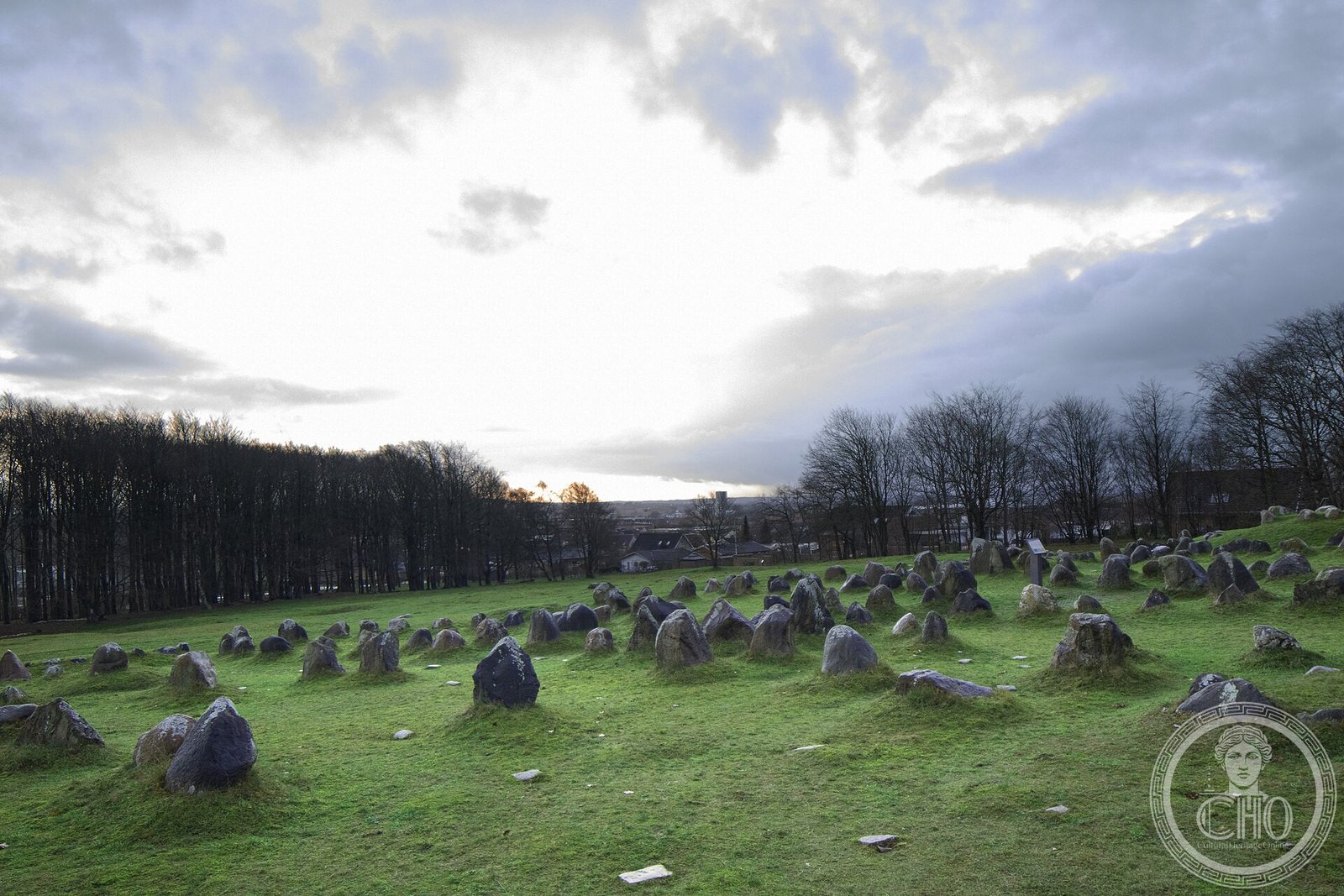
Above the Limfjord in Jutland, approximately 700 graves from the Germanic Iron Age and Viking Age are outlined in stones arranged as ship silhouettes — the largest preserved Viking burial ground in Scandinavia, sealed for a thousand years beneath wind-blown sand and emerging from excavation in 1952 essentially intact.
At a glance
Lindholm Høje (Lindholm Heights) is a ridge 2 km north of Aalborg bearing the most extensive and best-preserved Viking-age burial ground in Scandinavia. Approximately 700 graves, dated between c. 400 and 1000 AD, are marked by oval, pointed, or triangular stone settings arranged to trace the outlines of ships — the vessel in which the dead person would travel to the afterlife. The stones were preserved beneath a layer of wind-blown sand that buried the site sometime in the late Viking Age; when the ground was excavated from 1952 onward, the settings emerged with their stones still precisely positioned, making Lindholm Høje the most legible large Viking burial landscape in existence.
Key facts
- Period: Germanic Iron Age through Viking Age, c. 400–1000 AD
- Number of graves: approximately 700, the largest Viking-age burial ground in Scandinavia
- Stone ships: oval and pointed stone settings 3–12 m long trace the silhouette of a vessel around each grave
- Preservation mechanism: the site was buried under 1–2 m of wind-blown sand in the Viking Age, protecting the stone settings perfectly until excavation
- Excavation: discovered 1952; systematically excavated by archaeologist Thorkild Ramskou through the 1950s–60s
- Grave goods: combs, knives, jewellery, gaming pieces, and sacrificed animal bones (sheep, horses) recovered from cremation pits
- Adjacent museum: Lindholm Høje Museet houses excavation finds and provides context for the burial landscape
History
The ridge above the Limfjord was used for burials across two distinct periods. The earliest graves, in the southern part of the cemetery, date from the Germanic Iron Age (c. 400–600 AD) and include a small number of inhumations of high-status individuals — one with a woman’s jewellery of exceptional quality suggesting a person of significant social rank. These graves predate the Viking Age stone-ship tradition and reflect burial practices common across much of northern Europe in the late Roman period. The later graves, from the Viking Age proper (c. 700–1000 AD), introduced the distinctive stone-ship settings: standing stones arranged in oval or pointed outlines of 3–12 metres around each cremation pit, mirroring the form of the vessels that were central to Viking-age cosmology and funerary symbolism.
The site was in active use as a burial ground for perhaps six centuries before the ridge was gradually overwhelmed by drifting sand, probably some time in the 11th century. The sand layer — typically 1–2 metres deep over the main cemetery area — proved to be a remarkable preservation agent: unlike most Viking-age burial grounds, where surface erosion and medieval ploughing have displaced grave markers and scattered grave goods, Lindholm Høje’s stone settings survived essentially undisturbed. The ground was first noted as archaeologically significant in the late 19th century; systematic investigation began only in 1952, when archaeologist Thorkild Ramskou of the National Museum of Denmark began what became a decade-long excavation, progressively clearing the sand and recording the positions of the stones.
The excavation transformed the known geography of Viking burial: it revealed that cremation was the dominant rite throughout the Viking Age at this site, with the deceased’s burned remains deposited in a shallow pit at the centre of the stone setting, sometimes accompanied by small personal items that survived the pyre. Larger and more elaborate stone settings — the bigger ships — are generally interpreted as marking graves of higher social status, though the correlation is not absolute. The site was formally protected as a Scheduled Monument in Denmark in 1941, before the main excavation began; it is now managed as an open archaeological park.
What you see today
The burial ground covers the top and upper slopes of the ridge in a dense concentration of stone settings visible from a distance. The southern cemetery, the densest part, contains rows of ship-outlines — oval and pointed configurations of pale grey standing stones — lying side by side like a fleet of beached vessels. The overall effect from the ridge crest, looking out over the Limfjord toward Aalborg, is of a hillside carpeted in silent stone ships: the closest visual approximation anywhere in Scandinavia to the Viking-age funerary landscape as it actually appeared when in use.
The Lindholm Høje Museet at the foot of the ridge houses the finds from the excavation and provides a panoramic view of the cemetery from its upper level. The museum’s displays include original grave goods (combs of antler, iron knives, bronze jewellery, glass beads), a reconstruction of the cremation process, and an account of the 1952–1968 excavation that uncovered the site. The burial ground itself is free to walk through at all times.
Practical information
- Address: Vendilsvej 11, 9400 Nørresundby, Aalborg, Denmark
- Opening: The burial ground is always open (free). The museum is open Tuesday–Sunday; check Aalborg Historiske Museum website for seasonal hours.
- Admission: Burial ground — free. Museum — DKK 50–80 (adult); free with Aalborg City Card.
- Best time to visit: The stone settings are visible year-round; low winter light emphasises the three-dimensional relief of the stones against the grass.
- Facilities: Museum café and shop; accessible parking at the museum entrance.
Getting there
Lindholm Høje is 2 km north of Aalborg city centre, on the north bank of the Limfjord. From Aalborg Central Station, take bus line 2 toward Nørresundby and alight at Lindholm Høje — journey approximately 20 minutes. By car from Aalborg, cross the Limfjord Bridge and follow the E45 northward, then take the signed exit. From Copenhagen, Aalborg is 4–5 hours by car on the E45, or 3.5 hours by train with a change at Fredericia or Aarhus.
Nearby
- Aalborg city centre — 2 km south; Budolfi Cathedral (c. 1400), the Aalborg Castle (1539), and the Utzon Center on the waterfront
- Rebild Bakker National Park — 30 km south; heathland and forest landscape with Iron Age burial mounds
- Fyrkat Viking ring fortress — 50 km southwest near Hobro; one of five Trelleborg-type Viking ring fortresses built under Harald Bluetooth c. 980 AD
- Aggersborg Viking fortress — 60 km west on the Limfjord; the largest of the five Trelleborg fortresses
Sources
- Thorkild Ramskou, Lindholm Høje: Gravpladsen (1976): definitive excavation report on the cemetery
- Thorkild Ramskou, Lindholm Høje: Bopladsen (1977): report on the associated settlement
- National Museum of Denmark (Nationalmuseet): excavation archive and finds catalogue
- Aalborg Historiske Museum: site management documentation and visitor interpretation materials
- Peter Pentz et al., Viking (2013), National Museum of Denmark: contextualises Lindholm Høje within Scandinavian Viking burial traditions
Find it on the map
See this place and what’s around it →📷 Become a Cultural Heritage Online photographer
Share your photos of places: they stay published under your name as the author. The more they're seen, the more you get noticed — and soon a contest will reward the most appreciated photos.
Log in or sign up free to add a photo