Le Morne Brabant
A dramatic black basalt monolith rising 556 metres from the southwest coast of Mauritius, Le Morne Brabant served as a mountain refuge for escaped slaves in the 18th and 19th centuries and is today the island’s most powerful symbol of resistance to slavery — recognised by UNESCO as a World Heritage Site in 2008.
At a glance
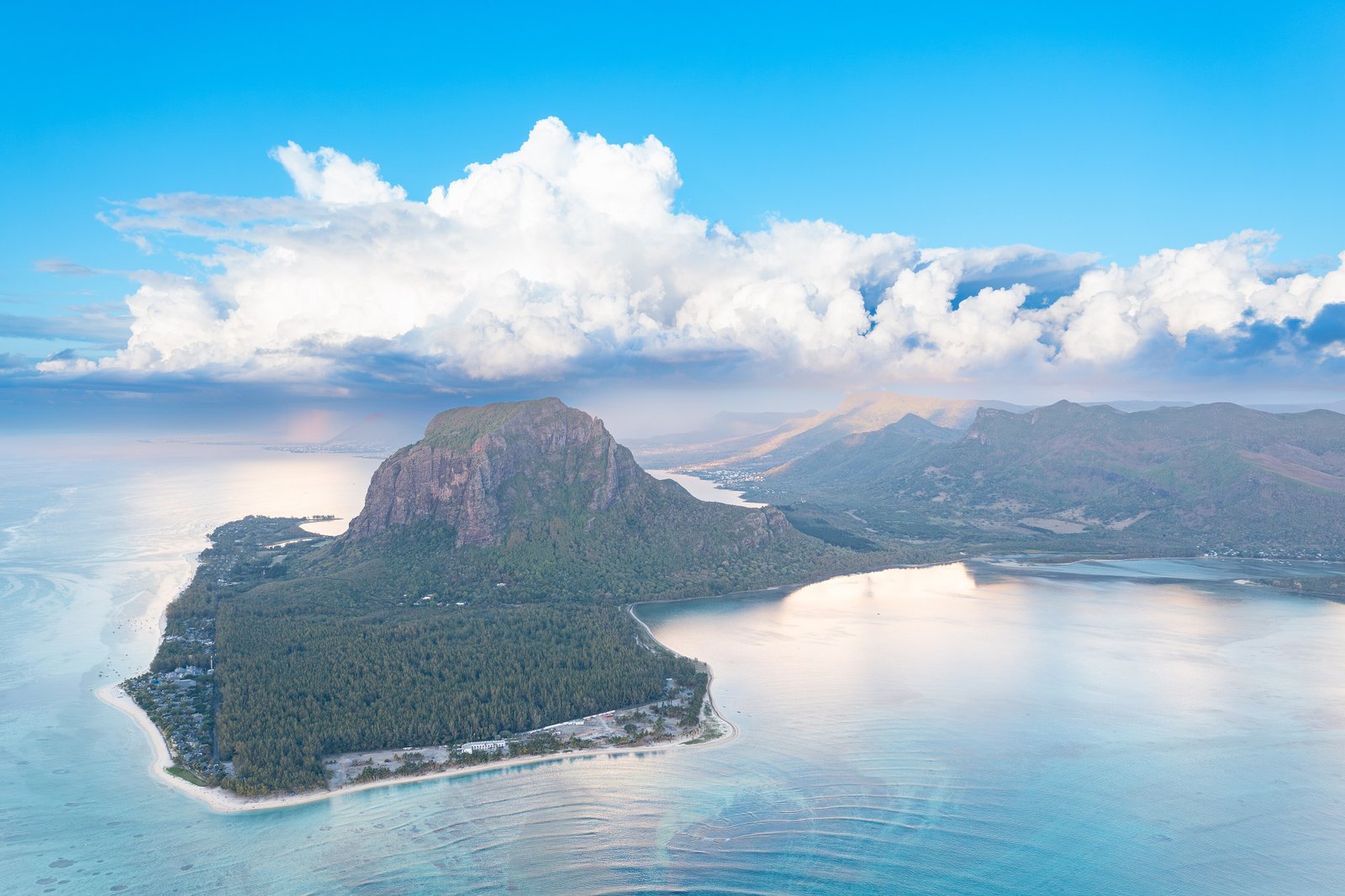
Le Morne Brabant is a peninsula formed by a massive basalt rock that juts into the Indian Ocean at the southwestern tip of Mauritius. Its near-vertical cliffs, dense vegetation, and hidden cave ledges made it an almost impenetrable refuge for maroons — enslaved people who escaped from the sugar plantations of colonial Mauritius and sought freedom in the mountain’s inaccessible interior. Communities of maroons lived there throughout the 18th and early 19th centuries, sustained by the terrain itself. The site became inscribed on the UNESCO World Heritage List in 2008 for its outstanding cultural value as a landscape of resistance and memory, representing the struggle against slavery across the Indian Ocean world.
Key facts
- Location: Black River District, southwestern Mauritius, Indian Ocean
- Coordinates: 20.4500° S, 57.3167° E
- Elevation: 556 metres above sea level
- UNESCO designation: World Heritage Site, 2008
- Criterion: UNESCO criterion (vi) — outstanding universal significance linked to slavery and its abolition
- Period of maroon refuge: c. 1700–1835 (slavery abolished in Mauritius 1835)
- Geology: Basalt intrusion; one of the oldest geological formations on Mauritius
- Associated tradition: Site of a tragic legend involving the misreading of troops as slave-hunters on the day of abolition
History
Mauritius was uninhabited until the late 16th century. The Dutch made brief attempts at settlement (1638–1710), followed by French colonisation from 1715, which brought the first large-scale importation of enslaved Africans and Malagasy to work sugar and indigo plantations. Under French rule (renamed Île de France) and subsequently under British control after 1810, the plantation economy expanded dramatically, driving ever more enslaved people to seek escape into the island’s interior.
Le Morne Brabant, with its sheer cliffs and dense forest, became one of the most significant maroon refuges in the Indian Ocean world. Communities of escaped slaves — men, women, and children — built shelters on the mountain’s hidden ledges and survived for years, even generations, beyond the reach of colonial slave-hunters and their dogs. The exact size of these communities is unknown; archaeological traces of their presence have been found in the form of shelters, pathways, and material remains on the mountain.
The site is associated with one of the most tragic episodes in Mauritian memory. According to tradition, in 1835 — on or around the date that slavery was officially abolished in the British colonies — a colonial military detachment climbed the mountain to inform the maroon communities of their legal freedom. The maroons, having spent years or generations in hiding from exactly such armed groups, interpreted the soldiers’ approach as a slave-hunting expedition and chose to throw themselves from the cliffs rather than be recaptured. The historical documentation of this specific event is incomplete, but the legend has become constitutive of Mauritian identity and the island’s relationship to its history of slavery.
Slavery was formally abolished in Mauritius on 1 February 1835, following the Slavery Abolition Act of 1833. An estimated 70,000 formerly enslaved people were freed; most remained on the island as indenture workers under transitional arrangements before Indian indentured labour became the dominant workforce from the 1840s onward.
What you see
Le Morne Brabant is experienced primarily as a landscape, not as a built monument. The basalt monolith dominates the southwestern horizon of Mauritius and is visible from great distances across the lagoon and from the neighbouring island of Rodrigues on very clear days. The peninsula’s base is fringed by white sand beaches, a turquoise lagoon, and mangrove wetlands — a contrast that makes the dark, brooding rock above appear all the more imposing.
The cliff faces rise almost vertically on all sides except the southeast approach, where a steep trail leads to the summit. Cave ledges and overhangs on the northern and western faces are believed to be where maroon communities sheltered; some of these are visible from certain approaches but are not open for casual exploration. The summit area offers panoramic views across the Morne Lagoon, the Le Morne Peninsula, the salt flats, and on clear days the southern coast of Mauritius stretching east.
A memorial statue at the base of the mountain, erected to commemorate the enslaved and their resistance, marks the site’s contemporary function as a place of memory and national identity. The Morne Heritage Trust Fund manages the site and has established interpretive infrastructure explaining the history of slavery and marronage on the island.
Why it matters
Le Morne Brabant represents a category of heritage site that extends beyond the conventional vocabulary of ruins and monuments. Its significance is memorial, cultural, and political: it is a landscape that carries the living memory of the enslaved and their resistance, in a region — the Indian Ocean — where the history of slavery has historically received less international attention than its Atlantic counterpart.
UNESCO’s inscription under criterion (vi) specifically recognised the site’s outstanding universal value as a symbol of the struggle against slavery, applicable not only to Mauritius but to the broader Indian Ocean world where the slave trade connected East Africa, Madagascar, India, and the islands for centuries. The World Heritage designation helped anchor the site’s protection within Mauritian law and international heritage frameworks.
The site is also significant geologically — the basalt monolith is among the oldest exposed rock formations on Mauritius, a remnant of the volcanic activity that created the island — but its cultural meaning far outweighs its geological interest in the contemporary heritage discourse.
Practical information
- Location: Le Morne village, Black River District, southwestern Mauritius
- Access: The base of the mountain and the beaches are freely accessible; the hiking trail to the summit requires registration with the Morne Heritage Trust Fund
- Hiking: Summit trail is steep (approximately 2–3 hours return); guide strongly recommended
- Morne Heritage Trust Fund: Provides guided tours, interpretive materials, and manages the cultural heritage of the site
- Nearby facilities: Luxury resort hotels line the Le Morne Peninsula beaches; restaurants and water sports operators at the base
- Best time to visit: May–November (cooler, drier season); avoid January–March cyclone season
Getting there
Le Morne is located approximately 40 km southwest of Port Louis (the capital) and about 50 km from Sir Seewoosagur Ramgoolam International Airport. By car from Port Louis, take the M1 motorway south then follow coastal roads to the Black River District (approximately 45–55 minutes). There is no direct public bus to the Le Morne Peninsula itself; buses run to Black River town, from which taxis are available for the remaining distance. Most visitors arrive by car or resort shuttle.
Nearby
- Black River Gorges National Park (~15 km northeast) — Mauritius’s largest national park; endemic flora and the endangered echo parakeet
- Chamarel (~20 km northeast) — Seven Coloured Earths volcanic phenomenon; Chamarel rum distillery
- Aapravasi Ghat, Port Louis (~40 km north) — UNESCO World Heritage Site; former indentured labour transit depot, 2006
- Blue Bay Marine Park (~70 km southeast) — UNESCO-protected coral reef lagoon
Sources
- Wikipedia — Le Morne Brabant
- UNESCO World Heritage — Le Morne Cultural Landscape
- Morne Heritage Trust Fund
- Allen, R.B. (2015). European Slave Trading in the Indian Ocean, 1500–1850. Ohio University Press.
Find it on the map
See this place and what’s around it →📷 Diventa un fotografo di Cultural Heritage Online
Condividi le tue foto dei luoghi: restano pubblicate con la tua firma come autore. Più vengono viste, più ti fai conoscere — e presto un concorso premierà le foto più apprezzate.
Accedi o registrati gratis per aggiungere una fotoDo you manage this place?
This page is read by travellers and heritage enthusiasts who find it on Google. Keep it accurate — and make it work for you. Free for non-profit heritage institutions.