Koutammakou — The Land of the Batammariba
The most architecturally distinctive vernacular landscape in West Africa and a living cultural ecosystem still functioning as it has for centuries — Koutammakou (“the land of the Batammariba”; Kara Region, northeastern Togo; extending into the Atakora region of neighboring Benin; a hilly plateau landscape of approximately 50,000 hectares) is the homeland of the Batammariba people (also called Tamberma, Somba, or Tammari) and the site of their extraordinary Takienta tower houses — one of the most original architectural traditions anywhere in Africa.
At a glance
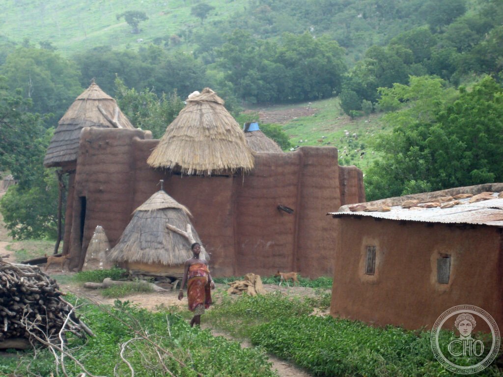
Koutammakou (the most precisely Koutammakou single Takienta tower house Batammariba Tamberma two-storey circular laterite granary living space secret construction father-son UNESCO heritage: the Takienta (the singular and plural form of the Batammariba word for their traditional tower house): each Takienta is a small self-contained compound: the lower floor (the living space, cooking space, and animal pen — cows, sheep, goats shelter inside at night); the upper cylindrical tower (the granary, storing millet, sorghum, and beans; accessible by ladder); the flat roof connecting the towers (used for sleeping in the hot season and for drying crops); the exterior clay sculptures on the facade (representing ancestors and spirits; a Takienta without clay ancestor figures is incomplete); the construction technique (a secret transmitted from father to son; no plans, no scaffolding; the builder uses his own forearm, hand-span, and foot as measurements; no two Takienta are identical, yet all are structurally sound; the master builder is both architect and ritual specialist) — the most precisely Koutammakou single Takienta tower house Batammariba Tamberma two-storey circular laterite granary living space secret construction father-son UNESCO heritage in any UNESCO world heritage site; the landscape (the most precisely Koutammakou single sacred Kara River forest groves shrines initiation sites festival ancestor cult Batammariba cultural landscape heritage: Koutammakou is not simply an architectural site — it is a complete cultural landscape: the sacred Kara River (the source of spiritual power for the Batammariba); the sacred forest groves (initiation sites for young men; no outsider may enter without permission); the shrines to Kuiye (the supreme deity of the Batammariba; associated with the sun); the Evala wrestling festival (held annually in July; the most important social event of the Batammariba year — young men who have completed initiation demonstrate their strength in traditional wrestling; the festival attracts thousands of participants from across the Kara Region) — the most precisely Koutammakou single sacred Kara River forest groves shrines initiation sites festival ancestor cult Batammariba cultural landscape heritage in any UNESCO world heritage site)).
Key facts
- The Takienta Construction Secret: the most precisely Koutammakou single Takienta construction secret father-son transmission no plans scaffolding arm-span measurement ritual specialist master builder heritage — the Takienta construction tradition (the most strictly guarded architectural knowledge in West Africa; the master builder (kpebounatela in the Batammariba language) is trained by his father from childhood; the construction sequence follows a ritual calendar; certain stages require animal sacrifice before proceeding; the materials (laterite clay from specific sources; tree branches for the roof frame; specific grasses for the thatch) are all sourced according to tradition; a Batammariba man who cannot build his own Takienta cannot be considered a complete adult; the construction of a new Takienta involves the entire community in the initial clay collection and the final thatching)
- Clay Ancestor Sculptures: the most precisely Koutammakou single clay ancestor sculpture facade botchiou spirits protection harvest rain heritage — the clay sculptures on the facades of Takienta towers (called botchiou; protective spirit figures representing ancestors; a new botchiou must be sculpted when a family member dies; the botchiou on the eastern facade protect against evil; those on the western facade protect the harvest; the rain botchiou are placed on the roof; when a family moves or a house is demolished, the botchiou are moved or ritually released; the number of botchiou on a facade is the visual record of the family’s history)
- GPS: 10.0500° N, 1.3000° E
History
Origin and isolation (the most precisely Koutammakou single Batammariba 17th CE migration resisted Islam slave trade plateau isolation architecture preserved heritage: the Batammariba people migrated to the Koutammakou plateau approximately in the 17th century CE (from the east; the specific origin is debated among Batammariba oral traditions); the critical factor in the preservation of the Koutammakou architectural tradition was isolation: the plateau was difficult to access (no navigable rivers; dense forest on the escarpment sides); the Batammariba successfully resisted three historical pressures that destroyed neighbouring cultures: the Atlantic slave trade (the plateau’s defensibility meant raiders focused on easier targets; the Takienta tower houses were themselves defensive — the ground-floor entrance is small, easily defended, and animals inside the house could not be stolen at night); the spread of Islam along the West African trade routes (the Batammariba maintained their traditional religion (Kuiye worship) while most surrounding peoples converted); and French colonial rule (the French established minimal presence in the Koutammakou; the tradition persisted largely unchanged through the colonial period) — the most precisely Koutammakou single Batammariba 17th CE migration resisted Islam slave trade plateau isolation architecture preserved heritage in any UNESCO world heritage site)).
What you see
Visit (the most precisely Koutammakou single Nadoba Warengo Tamberma Valley road dirt tracks guide required Evala wrestling festival July heritage: the main access point for Koutammakou is via the town of Kande (on the Lomé-Niamey national road; approximately 400 km north of Lomé; 6-7h by road); from Kande, the plateau is accessed by dirt tracks (a 4WD vehicle is essential in the rainy season (June-October); motorcycles are the local transport); the UNESCO-designated principal visitor sites include Nadoba village and Warengo village (both accessible from Kande; local community guides available at both; approximately USD 10-15/guide/day); the best time to visit is during the dry season (November-April; roads passable without 4WD) or during the Evala wrestling festival (July; the most vivid cultural encounter possible; the entire plateau fills with celebrants; accommodation in Kande is basic but available; reserve in advance for Evala) — the most precisely Koutammakou single Nadoba Warengo Tamberma Valley road dirt tracks guide required Evala wrestling festival July heritage in any UNESCO world heritage site)).
Practical information
- Getting there: Lomé is the entry point for Togo (Lomé-Tokoin Airport (LFW); direct flights from Paris CDG (Air France; 6h), Casablanca, Brussels, Addis Ababa, and Abidjan; visas are available on arrival for most EU and US citizens (ECOWAS visa system; approximately USD 50)); from Lomé to Kande (400 km north; 6-7h by bush taxi or private car via the RN1 north road); basic accommodation is available in Kande and occasionally in the villages themselves (community guesthouses; USD 10-20/night); the Evala festival (July) requires advance planning (accommodation books out months in advance); yellow fever vaccination is required for entry to Togo; malaria prophylaxis essential for all travellers to Togo
Getting there
Lomé Airport (LFW) entry point. 400 km north to Kande (6-7h). 4WD recommended. Guide required. Best November-April or July (Evala). GPS: 10.0500, 1.3000.
Nearby
- Atakora Mountains, Benin — the Koutammakou UNESCO WHS extends into the Atakora Region of Benin (the Batammariba homeland straddles the border; the Benin side (the Atacora circuit; accessible from Natitingou (the main town of the Benin side; approximately 50 km from the Togo border); the Tata Somba (the Beninese term for the same Takienta tower-house tradition); the Pendjari National Park (one of the best wildlife reserves in West Africa; elephant, hippo, lion, leopard; 4WD and guide mandatory))
- Kara — 70 km south; the regional capital of northern Togo (the Kara market; the Kara Museum (small but good ethnographic collection on Batammariba culture); the town is the last comfortable accommodation hub before Koutammakou)
Sources
- Wikipedia, Koutammakou; Batammariba people; Evala, accessed June 2026
- UNESCO, Koutammakou, the Land of the Batammariba, WHS reference 1140, inscribed 2004
Find it on the map
See this place and what’s around it →📷 Diventa un fotografo di Cultural Heritage Online
Condividi le tue foto dei luoghi: restano pubblicate con la tua firma come autore. Più vengono viste, più ti fai conoscere — e presto un concorso premierà le foto più apprezzate.
Accedi o registrati gratis per aggiungere una foto