Kakadu National Park
The most important Aboriginal rock art landscape in the world and one of the oldest continuously inhabited places on Earth — Kakadu National Park in the Northern Territory of Australia encompasses 19,840 square kilometres of floodplain, monsoon forest, and ancient sandstone escarpment and contains over 5,000 rock art sites representing at least 65,000 years of Aboriginal habitation; it is co-managed by the Bininj/Mungguy Aboriginal custodians and the Australian Government as one of the world’s most significant natural and cultural heritage landscapes.
At a glance
Kakadu National Park is located 170 km east of Darwin (the Northern Territory capital) and covers approximately 19,840 km² — larger than Wales or Northern Ireland — stretching from the coast of Van Diemen Gulf south through the floodplains of the South Alligator River to the Arnhem Land Plateau; the landscape has six distinct zones: the coastline and tidal flats (estuarine zone), the floodplains (billabongs and seasonal wetlands), the lowland savanna, the stone country of the Arnhem Land escarpment (the ancient Kombolgie Sandstone plateau), the outliers (isolated sandstone masses rising from the plains), and the southern hills and basins; the park is home to more than one third of all bird species found in Australia, the largest population of saltwater crocodiles (Crocodylus porosus) in Australia, and rare species including the pig-nosed turtle, the freshwater sawfish, and the black wallaroo; the monsoon climate creates two distinct seasons: the Dry Season (April–October, the visitor season) and the Wet Season (November–March, when most access roads are impassable but the landscape is spectacularly green).
Key facts
- The rock art sites (Ubirr and Burrungkuy/Nourlangie): the most important gallery of Aboriginal rock art in Australia and among the most significant in the world — Kakadu contains over 5,000 rock art sites (estimated; the total may be considerably higher — the sandstone shelters of the Arnhem Land escarpment are so numerous and so inaccessible that comprehensive survey is impossible); the art spans at least 20,000 years (the oldest dated examples; some archaeologists have argued for dates of up to 30,000 years) and documents dramatic changes in the environment and culture of Aboriginal Australians (the subjects shift over time from species that are now extinct — thylacine, megafauna — to species that are still present, reflecting environmental changes over millennia); the two main accessible sites are: Ubirr (north Kakadu; a complex of sandstone overhangs with paintings from multiple periods; the “Rainbow Serpent” figure — an ancestral creation being fundamental to Aboriginal spiritual life throughout Arnhem Land — is the most sacred figure; the walk-through galleries at Ubirr take approximately 1–2 hours; the lookout at the top of the Ubirr formation gives panoramic views of the Nadab floodplain) and Burrungkuy/Nourlangie (south-central Kakadu; the Anbangbang Gallery has the most complete and best-preserved example of “X-ray” rock art — a painting style unique to Arnhem Land in which the internal anatomy of fish, kangaroos, and humans is depicted alongside their external form; the main figures at Burrungkuy include Namarrgon the Lightning Man — depicted with stone axes on his head, elbows, and knees — who is responsible for the storms of the Wet Season)
- The Bininj/Mungguy people and the land custodianship: the oldest continuous human culture in Australia on one of the oldest continuously occupied territories on Earth — the Aboriginal peoples who are the traditional owners of Kakadu (the Bininj in the north and west, the Mungguy in the south and east) have maintained an unbroken connection to their Country for at least 65,000 years (the date established by archaeological excavations at Madjedbebe/Malakunannja II, a rock art site on the edge of Kakadu, which produced stone tools reliably dated to 65,000 BP — the oldest confirmed evidence of human occupation in Australia, making the Kakadu region one of the oldest continuously inhabited places on Earth); the land was returned to Aboriginal ownership via Aboriginal Land Rights legislation in 1978 and is leased back to the Commonwealth of Australia as a National Park; the park is co-managed by a Board of Management with a majority of Aboriginal members; 50% of park fees go to the Aboriginal landowners; some areas of the park are restricted from visitor access because they are ceremonially sacred
- The Yellow Water Billabong (Ngurrungurrudjba): the single most spectacular wildlife-watching destination in Australia — Yellow Water (Bininj/Mungguy name: Ngurrungurrudjba; “big river water running out”) is a permanently watered billabong (oxbow lake) on the South Alligator River floodplain in the heart of Kakadu; it is surrounded by paperback (Melaleuca) forests, pandanus palms, and lotus lilies; in the late dry season (August–September) the concentration of wildlife around the water is extraordinary: saltwater crocodiles (up to 5 metres long) bask on the banks and hunt in the water; Jabiru storks, Magpie Geese, Jacanas, and Brolgas (the tall grey cranes that give Kakadu its principal symbol) feed in the shallows; the dawn and dusk boat cruises on Yellow Water (operated by Cooinda Lodge, the main accommodation inside the park) are consistently rated among the best wildlife experiences in Australia
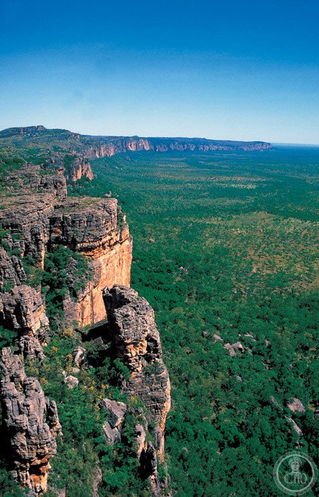
- The Arnhem Land escarpment and Jim Jim Falls: the geological heart of Kakadu and the most visually dramatic landscape — the Arnhem Land Plateau (the ancient Kombolgie Sandstone, 1.6 billion years old) forms the dramatic eastern boundary of Kakadu; the escarpment (a continuous cliff face rising up to 300 metres above the surrounding plains) is the source of the waterfalls that cascade off the plateau in the Wet Season; Jim Jim Falls (the tallest waterfall in Kakadu, approximately 200 metres; accessible by 4WD via a 60 km rough track from the Kakadu Highway; the plunge pool is one of the most beautiful natural swimming locations in Australia in the Dry Season — deep blue water, white sand, surrounded by sheer sandstone walls 200 metres high); Twin Falls (accessible by boat and a short walk from the Jim Jim 4WD track)
- Heritage: UNESCO World Heritage Site, Kakadu National Park, inscribed 1981 (Stage I), extended 1987, 1992; one of the first properties inscribed under both cultural and natural criteria
- GPS: -12.6740° S, 132.9340° E (Yellow Water Billabong, central Kakadu)
History
Human occupation of the Kakadu region dates to at least 65,000 BP (Madjedbebe site); Aboriginal occupation is continuous to the present; European contact (British naval surveyor Matthew Flinders, 1803); pastoral leases in the 19th century; gold and uranium discovery (uranium mining at Jabiru/Ranger Mine, adjacent to but outside the park boundary, began 1981; mining lease expired 2021; rehabilitation ongoing); Aboriginal Land Rights Act 1976 enabled land return; Kakadu National Park declared 1979–1981; UNESCO WHS Stage I (12,400 km²) 1981; Stages II and III extended 1987, 1992 (to 19,840 km²).
What you see
Most visitors base themselves at either Jabiru (the park service town in the north; accommodation, supermarket, petrol) or Cooinda Lodge (the lodge closest to Yellow Water in the south); the main visitor circuit covers: the Bowali Visitor Centre near Jabiru (an excellent introduction to Kakadu’s ecosystems and Aboriginal culture; allow 1h); the Warradjan Aboriginal Cultural Centre near Cooinda (the best explanation of Bininj/Mungguy culture and cosmology; allow 1h); Ubirr rock art site (3h, including the Nadab Lookout walk; go at dusk for the colours on the rock surface); Yellow Water Billabong dawn boat cruise (6am–8am; the most recommended single activity in Kakadu; book well ahead at Cooinda Lodge reception); and Burrungkuy/Nourlangie rock art site (2h; the Anbangbang Gallery and the shelter are the highlights).
Practical information
- Entry fees and planning: AUD $40 per adult (7-day park pass; available online or at the park entry stations); children under 16 free; the park is open year-round but the Dry Season (April–October) is the visitor season — in the Wet Season (November–March), most unsealed roads are flooded, Jim Jim and Twin Falls are inaccessible, and Ubirr may be closed; the Wet Season has spectacular electrical storms and lush green landscapes; the best time to visit is May–September (cooler, all roads open, maximum wildlife at waterholes); 4WD is essential for Jim Jim Falls and Twin Falls; a standard 2WD car is sufficient for Ubirr, Yellow Water, Nourlangie, and the main visitor centres; the Yellow Water dawn boat cruise must be booked in advance (Cooinda Lodge, 24–48 hours recommended, much more in peak season July–August)
- Getting there: from Darwin: 170 km east on the Arnhem Highway (approximately 2h by car); Darwin Airport is served by direct flights from Sydney, Melbourne, Brisbane, and Singapore (among others); the bus service from Darwin to Kakadu (Greyhound Australia coach to Jabiru; approximately 3h) is the main public transport option; guided tours from Darwin are numerous (one-day and multi-day tours including 4WD tours to Jim Jim Falls are the most popular); camper van rental from Darwin is a practical option for independent multi-day exploration; the total park is too large to see in a single day — a minimum of 2 nights (3 days) is needed to do justice to the key sites
- Wildlife safety: Kakadu is saltwater crocodile country; swimming in rivers, billabongs, or any water where crocodile warning signs are posted is extremely dangerous and is prohibited; the only safe swimming areas are clearly signed (Jim Jim plunge pool when the crocodile-exclusion programme is active in the Dry Season; pool at Cooinda Lodge; specific swimming holes near Gunlom); standard Australian outback precautions apply: carry 3+ litres of water per person in the heat, apply insect repellent (mosquitoes carry Ross River Virus and other pathogens), wear sun protection
Getting there
From Darwin (170 km east, 2h by car on Arnhem Highway). Greyhound coach from Darwin to Jabiru (3h). 4WD required for Jim Jim Falls track. GPS: -12.6740, 132.9340.
Nearby
- Darwin and the Top End — 170 km west of Kakadu (2h by car); the gateway city for Kakadu and one of the most culturally diverse cities in Australia — Darwin (population approximately 150,000; founded 1869; the northernmost Australian capital) was virtually destroyed by Japanese bombing raids in 1942 (the first Japanese attack on Australian soil, on 19 February 1942; 64 aircraft were involved; more bombs fell on Darwin on that day than on Pearl Harbour) and was rebuilt as a modern tropical city; the Museum and Art Gallery of the Northern Territory (the Territory museum; the Cyclone Tracy diorama — Cyclone Tracy destroyed 71% of Darwin’s buildings on Christmas Eve/Christmas Day 1974, the most destructive cyclone to hit an Australian city — and the Aboriginal Art collection are the most significant exhibits), the Darwin Waterfront Precinct (a successful harbour regeneration project), and the Mindil Beach Sunset Markets (the most atmospheric night market in northern Australia; every Thursday and Sunday in the Dry Season, with food stalls, crafts, and a direct view of the sunset over the Timor Sea) are the main city attractions
- Nitmiluk National Park (Katherine Gorge) — 250 km south of Kakadu (3h by car); the most dramatic gorge landscape in the Northern Territory — Nitmiluk (the Jawoyn Aboriginal name) features a system of 13 sandstone gorges carved by the Katherine River through the Arnhem Land Plateau; the gorges are only fully connected during the high Wet Season floods; in the Dry Season, the river drops to a series of still pools separated by rock bars, which can be walked between; canoe hire (half-day to multi-day self-guided canoe trips through the gorges) is the principal activity; the canyon walls rise 70 metres above the water; Aboriginal rock art is visible on the canyon walls at several points accessible only by canoe; the sunset colours on the red sandstone walls reflected in the still water are exceptionally beautiful
- Litchfield National Park — 120 km south-west of Darwin (1h 30 min by car); the most visited national park in the Northern Territory for day trips from Darwin — Litchfield (640 km²) is smaller and more accessible than Kakadu and is the primary bush-swimming destination for Darwin residents; the park contains Florence Falls (a twin waterfall plunging into a deep green plunge pool safe for swimming in the Dry Season), Wangi Falls (the most impressive waterfall in the park; the plunge pool is very large and is the standard weekend swimming spot for Darwin families; a crocodile-exclusion fence at the bottom of the pool provides safety from the estuarine crocodiles that inhabit the river below), magnetic termite mounds (flat, blade-like termite mounds aligned north-south to regulate temperature — a convergent evolution unique to this species in the Top End), and the Lost City (weathered sandstone columns resembling a ruined city)
Sources
- Wikipedia, Kakadu National Park; Bininj Kunwok; Ubirr; Madjedbebe, accessed June 2026
- UNESCO, Kakadu National Park, WHS reference 147, inscribed 1981
- Parks Australia, Kakadu National Park — Park Management Plan 2016–2026
- Clive Roberts, Kakadu: The Making of a National Park, Melbourne University Press, 2004
Find it on the map
See this place and what’s around it →📷 Diventa un fotografo di Cultural Heritage Online
Condividi le tue foto dei luoghi: restano pubblicate con la tua firma come autore. Più vengono viste, più ti fai conoscere — e presto un concorso premierà le foto più apprezzate.
Accedi o registrati gratis per aggiungere una foto