Ani
The most haunting medieval ruin in the Middle East — Ani, the capital of the Bagratid Armenian kingdom in the 10th and 11th centuries and one of the largest and most sophisticated cities of its era (population approximately 100,000), was reduced to uninhabited ruins by successive invasions and a devastating earthquake; the grass-covered basalt plateau above the Akhurian River (the Turkish-Armenian border) is strewn with the ruins of a once-great city: cathedrals, mosques, palaces, bath-houses, and city walls, all slowly returning to the Anatolian steppe.
At a glance
Ani occupies a naturally fortified triangular plateau defined by the Akhurian River (the border between Turkey and Armenia) on the east and south, and the Alaca çay gorge on the west; the plateau is connected to the surrounding uplands only on the north, which is where the famous double city wall (the “Wall of Smbat” and the “Wall of Manuchihr”; constructed in the 10th century and repaired by the Seljuk Turks after their capture of the city in 1064) is located; the entire plateau (approximately 4 km²) is an open-air archaeological site accessible to visitors; the nearest major city is Kars (45 km west), which is connected to Erzurum (190 km south-west) by road and train; the site is easily accessible as a day trip from Kars; most visitors combine Ani with the steppe landscapes of the Kars Plateau, which are exceptional in spring (May–June, when the plateau is covered with wildflowers).
Key facts
- The Bagratid Kingdom of Armenia (885–1045) and the city of Ani: the most powerful Armenian state of the medieval period and the city that embodied it — the Bagratid dynasty of Armenia (Armenian: Բագրատունիներ; the family claimed descent from the Old Testament king David and from the attendants of Christ’s entombment) established an independent Armenian kingdom in 885 after the fragmentation of the Abbasid Caliphate; the capital Ani was established in 961 when King Ashot III moved his court there from Kars; under King Gagik I (r. 990–1020), Ani reached its greatest extent and population; the city was a major node of the Silk Road (on the route between Constantinople and Tabriz, controlling traffic through the Caucasus) and a great centre of Armenian culture and architecture; the Cathedral of Ani (989–1010 AD; the most accomplished example of medieval Armenian religious architecture) was its greatest monument; the Bagratid kingdom was weakened by fragmentation and absorbed by the Byzantine Empire in 1045; the Seljuk Turks captured Ani in 1064 under Sultan Alp Arslan (just two years before the Battle of Manzikert, which broke Byzantine power in Anatolia)
- The Cathedral of Ani (989–1010 AD, Architect Trdat): the masterpiece of medieval Armenian religious architecture — the Cathedral of Ani was commissioned by Queen Katranide (wife of King Smbat II) and completed by King Gagik I; it was designed by the Armenian architect Trdat (who had also repaired the damaged dome of the Hagia Sophia in Constantinople after the 989 earthquake, as recorded in Byzantine sources — the only non-Byzantine architect known to have worked on Hagia Sophia); the Cathedral of Ani is a basilica with a central dome, pointed arches (one of the earliest uses of the pointed arch in the world, predating the Gothic by more than a century), and a complex system of blind arcading and decorative interlace on the exterior; the building stands to approximately half its original height; the dome collapsed (probably in the 1319 earthquake); the exterior decoration (blind arcading with deeply carved geometric and floral interlace, the paired pilasters with carved capitals) is the finest example of medieval Armenian stone carving in existence
- The Seljuk capture (1064) and the subsequent centuries: five centuries of cyclical destruction and partial recovery — Sultan Alp Arslan captured Ani in 1064 after a siege; he converted the Cathedral into a mosque (the Cathedral remained as a mosque throughout the subsequent Islamic periods); the Seljuks were followed by the Georgian king David IV (who briefly captured Ani in 1124), then the Kurdish Shaddadid dynasty, then the Georgian Queen Tamar (who controlled the city 1199–1209); the Mongols sacked Ani in 1239 (their first major raid in the Caucasus; the Mongol destruction was less complete than their Central Asian campaigns — the city was recovered and partially rebuilt); the Timurids under Timur sacked the city in the 1380s–1390s; a major earthquake in 1319 collapsed the Cathedral dome and other major structures; by the 15th century the city was essentially uninhabited; the Ottomans controlled the site from the 16th century until 1918
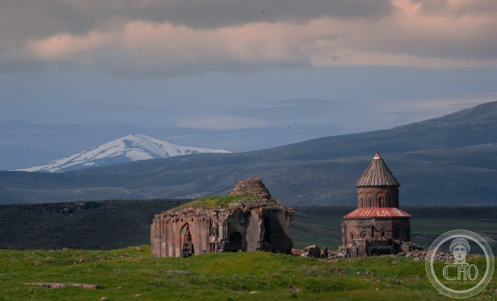
- The Church of the Holy Redeemer (1036 AD): the second most important church in Ani and the most poignant ruin — the Church of the Holy Redeemer (also called the Church of the Holy Apostles) was built in 1036 to hold a fragment of the True Cross; the church was struck by lightning in 1957 and exactly half of it collapsed, leaving one perfect half-cross section of the church standing (with the half-dome, the half-nave, and the half-facade visible from outside) and a rubble pile where the other half once stood; the result is the most dramatic architectural cross-section of a medieval church in existence; the profile of the collapsed face reveals the full construction history of the building — the stone courses, the wooden tie beams (now rotted away, leaving empty channels in the stone), the stucco plaster of the interior walls, and the thickness of the dome ribs
- Heritage: UNESCO World Heritage Site, Archaeological Site of Ani, inscribed 2016
- GPS: 40.5070° N, 43.5728° E
History
Ani was settled from pre-Christian times; the Bagratid dynasty made it their capital in 961; the city reached its peak population (estimated 100,000) under Gagik I (990–1020); the Cathedral was completed 1010; the Byzantine Empire absorbed the Bagratid kingdom 1045; the Seljuk Turks under Alp Arslan captured the city 1064; successive Georgian, Seljuk, and Kurdish periods of control; Mongol sack 1239; Ilkhanate period; Timurid raids 1380s; earthquake 1319 collapsed major structures; gradual abandonment 15th century; Ottoman control from 1500s; Russian rule 1878–1918; Republic of Turkey from 1921; archaeological excavations by Russia (19th century), Turkey (intermittent); UNESCO inscription 2016; restoration work ongoing.
What you see
Enter through the Aslan (Lion) Gate in the northern city wall (the main Bagratid-period gate; the lion relief above the arch gave it its name); walk south along the main street to the Cathedral (the largest and most complex ruin; the east facade with its blind arcading is the best-preserved external elevation; the pointed arches at the top of the nave walls reveal the Armenian origin of Gothic pointed arch vaulting); the Church of the Holy Redeemer is 300 metres north-east of the Cathedral (the half-standing church is unmistakable and surreal); the Manuchihr Mosque (the oldest mosque in Anatolia, c. 1072 AD; built by the Seljuk governor of Ani; a minaret with a Persian spiral staircase pattern survives to its full height) is between the Cathedral and the eastern cliff above the Akhurian River; the palace ruins and the remains of the bazaar street (the rows of shop foundations are the most evocative evidence of the commercial city) are south of the Cathedral toward the river gorge cliffs.
Practical information
- Admission and access: approximately 100 Turkish Liras (check current price; approximately €3–5 depending on exchange rate; the Lira has been volatile); open 8am–7pm (summer), 8am–5pm (winter); the site is exposed on a high Anatolian plateau (elevation 1,500 metres) with strong winds and intense sun in summer; bring a hat, sunscreen, and a windproof jacket even in summer; in winter (November–April) the plateau is frequently covered in snow and the roads from Kars can be icy; the best season is May–June (wildflowers) or September–October (clear air, moderate temperatures); the site is large (4 km² of ruins) and a full visit takes 3–4 hours; wear comfortable walking shoes suitable for rough terrain
- Getting there: from Kars (45 km east): take a dolmuş (shared minibus) from Kars bus station to Ocaklı village (near Ani; approximately 45 minutes; dolmuş run irregularly; a taxi from Kars (approximately 200 TL round trip including waiting time) is more reliable; alternatively, hire a car in Kars for the day (the Kars Plateau is also worth exploring for its steppe landscapes and Seljuk tomb monuments); Kars is accessible from Erzurum (190 km) by road; train connections from Kars to Ankara and Istanbul run through Erzurum; the Kars-Tbilisi-Baku railway passes near Kars
- The northeastern Turkey circuit: Ani is best visited as part of a northeastern Turkey circuit that includes: Mount Ararat (the Armenian national symbol; visible from parts of the Kars Plateau on clear days; rising to 5,137 metres; the biblical mountain of Noah’s Ark; now on the Turkish-Iranian-Armenian border triangle; the Iğdır side of the mountain is the most accessible for Turkish visitors; a view from the approach road near Doğubeyazıt is the standard tourist vantage point), Ishak Pasha Palace near Doğubeyazıt (a spectacular 17th–18th-century Ottoman palace on a rocky spur above the plain; one of the finest examples of late Ottoman palatial architecture; the most photographed monument in eastern Turkey), Lake Van (the largest lake in Turkey; the Urartian-period Armenian church island of Akdamar — the Church of the Holy Cross, 915 AD; the finest surviving example of medieval Armenian relief stone carving), and the Sümela Monastery (the rock-face Greek Orthodox monastery near Trabzon)
Getting there
From Kars (45 km west, 45 min by dolmuş or taxi). From Erzurum (190 km, 2h 30 min by car). GPS: 40.5070, 43.5728.
Nearby
- Kars’s Ottoman and Russian heritage — 45 km west of Ani; a compact 19th-century Russian-planned city with unusual architectural character — Kars was part of the Russian Empire from 1878 to 1921 (captured from the Ottomans in the Russo-Turkish War of 1877–78); the Russians completely rebuilt the town on a grid plan with wide boulevard-style streets (an unusual planning anomaly in eastern Turkey, where most towns are the organic accumulation of centuries); the Russian-period buildings (the Cathedral of the Apostles — now the Kümbet Camii mosque — the Russian barracks, the Governor’s Palace) give Kars an architectural character unlike any other city in Turkey; the Kars Museum has significant Urartian-period collections; the local Kars kashar cheese (a hard yellow aged cheese that is one of Turkey’s most important agricultural products; the high-altitude grass of the Kars Plateau gives the milk an unusual mineral richness) is available at local shops and is the obligatory food souvenir
- Church of the Holy Cross, Akdamar Island (Lake Van) — 280 km south of Ani (3h by car); the finest surviving example of medieval Armenian monumental stone sculpture — the Church of the Holy Cross on Akdamar Island in Lake Van (915 AD; built by King Gagik-Khachik I of Vaspurakan) is covered on its exterior in bas-relief sculpture of extraordinary quality: Old Testament scenes (Adam and Eve, Jonah and the whale, the sacrifice of Isaac, David and Goliath), the life of Christ, hunting scenes and mythological animals, all carved in high relief across the entire exterior surface of the building; this combination of exterior figural relief sculpture with church architecture is unique to Armenian ecclesiastical tradition and is not paralleled in Byzantine or Romanesque Christian art; the church is accessible by boat from the Van Gölü İskelesi (boat dock) near Gevaş; the boat crosses the 3 km of lake to the island; the restoration of the church by Turkish authorities (2005–2010) was controversial but the building is now structurally stable
- İshak Paşa Sarayı (Ishak Pasha Palace) — 175 km south-east of Ani (2h by car); the most spectacular Ottoman palatial building in eastern Anatolia — the Ishak Pasha Palace (late 17th–early 18th century; completed c. 1784 by İshak Paşa, the Ottoman governor of Doğubeyazıt) sits on a dramatic rocky spur 2,000 metres above sea level overlooking the Ağrı plain and Mount Ararat; the building combines Ottoman, Seljuk, Georgian, Armenian, and Persian architectural styles in an eclectic fusion that is unique in Anatolian architecture; the harem, the selamlık (men’s quarters), the mosque with its intact minaret, the kitchen wing, and the monumental entrance portal are all accessible; the view of Mount Ararat (5,137 metres; visible from the palace courtyard on clear days) is one of the most dramatic natural backdrops in the world
Sources
- Wikipedia, Ani; Bagratid Armenia; Trdat (architect); Church of the Holy Redeemer, Ani, accessed June 2026
- UNESCO, Archaeological Site of Ani, WHS reference 1518, inscribed 2016
- Sirarpie Der Nersessian, The Armenians, Thames and Hudson, 1969
- Seta B. Dadoyan, The Armenians in the Medieval Islamic World, vol. 1–3, Transaction Publishers, 2011–2014
Find it on the map
See this place and what’s around it →📷 Diventa un fotografo di Cultural Heritage Online
Condividi le tue foto dei luoghi: restano pubblicate con la tua firma come autore. Più vengono viste, più ti fai conoscere — e presto un concorso premierà le foto più apprezzate.
Accedi o registrati gratis per aggiungere una foto