Incisioni Rupestri della Valcamonica — 140.000 Petroglifi dal Mesolitico all’Età Romana (8000 a.C. – I sec. d.C.): il Più Grande Corpus di Arte Rupestre d’Europa (UNESCO 1979)
The rock carvings of Valcamonica are the largest single corpus of prehistoric rock art in Europe — over 140,000 figures engraved over a period of 10,000 years on the glacially polished sandstone surfaces of a 70-kilometre valley in the Alps north of Brescia, beginning in the Mesolithic (c. 8000 BCE) and continuing without interruption through the Neolithic, the Copper Age, the Bronze Age, the Iron Age, and the Roman occupation until the first century CE, creating a continuous visual record of human activity, belief, and social change that has no equivalent anywhere in the world.
At a glance
Valcamonica (the Valley of the Camonica River, province of Brescia, Lombardia) is a UNESCO World Heritage Site inscribed in 1979 (ref. 94) as “Rock Drawings in Valcamonica” — the first Italian site to receive UNESCO World Heritage status, and one of the first 12 inscriptions in the world (the first list, compiled in 1978, had only 8 sites; the 1979 additions included Valcamonica). The inscription covers the entire complex of carved rocks in the valley, concentrated in several designated parks and reserves between the communes of Capo di Ponte, Darfo Boario Terme, Nadro, Paspardo, Cimbergo, and Sellero. The rocks belong to the Camuno people (or Camunni), an Alpine tribe mentioned by Roman historians (Tacitus, Pliny the Elder, Augustus), who were conquered by Rome in 16 BCE and integrated into the Roman province of Raetia.
Key facts
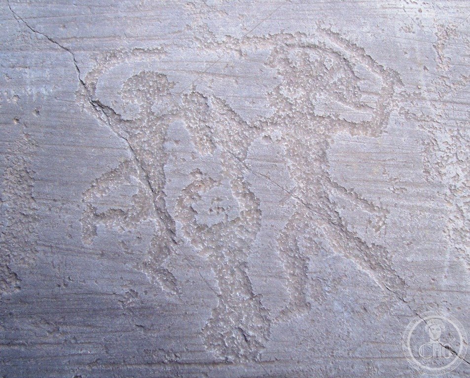
- Numbers: Over 140,000 individual figures (the precise count is difficult because new figures are continuously being discovered — the estimate was 70,000 in 1979, 130,000 by 2000, and continues to rise with new survey methods); distributed across approximately 2,400 individual carved rock surfaces in a 70-km valley; concentrated in several main areas: Naquane (the principal park, 104 carved rocks), Bedolina-Seradina (the second main area, with the famous Bedolina Map), Luine (Bronze Age warrior scenes), and Foppe di Nadro-Ceto (Iron Age and Roman period carvings)
- Chronological range: The oldest carvings date from approximately 8000 BCE (Mesolithic: simple linear signs and animal tracks); the most numerous period is the Copper Age (c. 3200-2300 BCE: deer, warriors, anthropomorphic “praying figures” with raised arms); the Bronze Age (c. 2300-900 BCE: warrior scenes with daggers, wheel-axle motifs, sun symbols); the Iron Age Camunni period (c. 900-16 BCE: the rose camuna symbol, huts and agricultural scenes, labyrinth motifs); Roman period (1st century BCE – 1st century CE: Latin inscriptions added to older carvings, Romanized warrior figures)
- The Rose Camuna: A spiral-and-petal geometric motif carved in thousands of variations across the valley in the Iron Age period; adopted in 1975 as the official symbol of the Lombardia region; the symbolic meaning is unknown (interpretations range from sun symbol to map of sacred space to territorial marker); it is one of the most reproduced prehistoric graphic motifs in the world
- The Bedolina Map (c. 1200-1000 BCE): A large flat rock at Seradina-Bedolina carved with a topographic representation interpreted as a map of the valley — hut symbols, field divisions, paths, water courses — one of the earliest examples of cartographic representation in prehistoric Europe
- UNESCO: 1979, ref. 94 — first Italian UNESCO inscription
- GPS: 46.0327, 10.3426 — Google Maps
History
The engraved rocks of Valcamonica were rediscovered and identified as prehistoric art in 1909 by the Italian archaeologist Raffaele Battaglia, who recognized that the carved figures he observed near Capo di Ponte were older than the Roman occupation of the valley. Systematic study began in the 1950s under the direction of Emmanuel Anati (b. 1930), the Israeli-Italian archaeologist who founded the Centro Camuno di Studi Preistorici at Capo di Ponte in 1964 and conducted the first comprehensive survey of the valley’s rock art, cataloguing the sites and developing the chronological sequence that remains the basis of current scholarship.
The Camunni, the Iron Age people who made the most numerous surviving carvings, were known to Roman authors: Pliny the Elder mentioned their skill as iron-workers; Augustus defeated them in his Alpine campaign of 16 BCE, and the Camunni appear in the list of Alpine peoples on the Trophy of Augustus at La Turbie (near Monaco). Their engraving practice may have been a form of territorial marking or votive dedication to mountain divinities (several carvings appear to mark boundaries between community territories, while others are concentrated near natural water sources associated with ritual practices). The practice continued after Roman conquest: some carvings from the 1st century CE incorporate Latin inscriptions, suggesting that the Camunni continued their engraving tradition while being integrated into Roman provincial culture.
What you see
The main visitor area is the Parco Nazionale delle Incisioni Rupestri di Naquane (Via Piana 29, Capo di Ponte), a 13-hectare hillside park with 104 carved rock surfaces, connected by signposted paths through alpine scrub forest. Rock 1 (the “Great Rock” / Grande Roccia) is the largest single surface in the park — a 100-metre-long sandstone outcrop covered with over 1,000 figures from multiple periods, including prehistoric warriors, deer, and the characteristic “praying figures” of the Copper Age. Rock 35 is particularly notable for the Bronze Age “Dueling Warriors” scene. The park provides numbered wooden markers at each carved rock, with explanatory panels in Italian and English.
The Riserva Naturale Incisioni Rupestri di Ceto, Cimbergo e Paspardo (the second main area, 8 km north of Capo di Ponte near Nadro) has a museum-park at Foppe di Nadro with carvings that include the finest Iron Age warrior and hunting scenes. The Parco Comunale delle Incisioni Rupestri di Seradina-Bedolina (near Capo di Ponte, between the town and the Naquane park entrance) contains the Bedolina Map rock. All three parks are connected by the “Sentiero dei Parchi” (Parks Trail), a 12-km walking route that links the three main areas.
Gallery
Practical information
- Parco Nazionale delle Incisioni Rupestri di Naquane: Via Piana 29, Capo di Ponte; open Tuesday-Sunday 8:30-19:30 (summer), 8:30-14:30 (winter, October-March); closed Monday. Admission ~€6 (EU citizens 18-25 ~€2; under 18 free). Photography allowed.
- Museo Nazionale della Preistoria della Valcamonica (MuPre): Via Marconi 7, Capo di Ponte; open Tuesday-Sunday 8:30-19:30; admission free (national museum). Contains original excavated artefacts from the valley and a comprehensive exhibition on the chronological phases of the rock art.
- Season: Best April-October (long daylight hours; the carvings are most visible in raking afternoon light or in grey overcast conditions — direct sunlight flattens the incisions). Bring walking shoes (rocky, uneven terrain) and binoculars (some carvings are above eye level).
- Duration: The Naquane park requires 1.5-2 hours. The full three-park circuit (with MuPre) requires a full day.
Getting there
Parco Nazionale delle Incisioni Rupestri, Via Piana 29, Capo di Ponte (BS), Lombardia. By train: Trenord from Brescia to Capo di Ponte (70 km; 1h40 regional, hourly — the Brescia-Edolo “Ferrovia Camuna” line). The Capo di Ponte station is 700 m from the Naquane park entrance. By car: from Brescia, SS42 north (70 km, 1h10 in normal traffic); from Bergamo, SS671 then SS42 (90 km, 1h30); from Milan, A35 to Brescia then SS42 north (130 km, 1h45).
Nearby
- Brescia — 70 km south; the Longobard UNESCO site (Santa Giulia Museum + Monastero di Santa Giulia, see CHO card); the Roman civic complex (Capitolium, 73 CE, with Temple of the Capitoline Triad; Theatre, 1st century CE; Museum of Santa Giulia with the excavated Roman ruins in the monastic complex); the Pinacoteca Tosio Martinengo (Raphael, Moretto da Brescia, Lorenzo Lotto, Romanino)
- Lago d’Iseo (Sebino) — 40 km south; the fourth largest pre-Alpine lake in Italy; the lake island of Monte Isola (the largest inhabited lake island in Europe; car-free, 2,000 inhabitants, reachable by ferry from Sulzano or Sale Marasino)
- Adamello-Presanella massif — north of Valcamonica; the largest continuous glacier in the Italian Alps (the Adamello glacier, 18 km²); trekking routes accessible from Ponte di Legno at the head of the valley
Sources
- UNESCO: whc.unesco.org/en/list/94
- Wikipedia EN: Rock drawings in Valcamonica
- Anati, Emmanuel: Camonica Valley, Knopf, 1961 (still the most accessible English-language introduction)
- Centro Camuno di Studi Preistorici: rockart-ccsps.com
Find it on the map
See this place and what’s around it →📷 Diventa un fotografo di Cultural Heritage Online
Condividi le tue foto dei luoghi: restano pubblicate con la tua firma come autore. Più vengono viste, più ti fai conoscere — e presto un concorso premierà le foto più apprezzate.
Accedi o registrati gratis per aggiungere una foto