Hoh Xil (Kekexili, sito naturale): l’altopiano tibetano più vasto e più alto della Terra
Nel nordest dell’altopiano Qinghai-Tibet, lontano da qualsiasi insediamento umano, si estende Hoh Xil: la più grande e alta regione selvaggia del pianeta, un altopiano di permafrost, laghi salati e praterie d’alta quota a oltre 4.500 metri. È il cuore della migrazione dell’antilope tibetana — il chiru — una delle più grandi migrazioni di ungulati rimaste sulla Terra, e dall’anno della sua iscrizione UNESCO (2017) è uno dei siti naturali più remoti del mondo.
At a glance
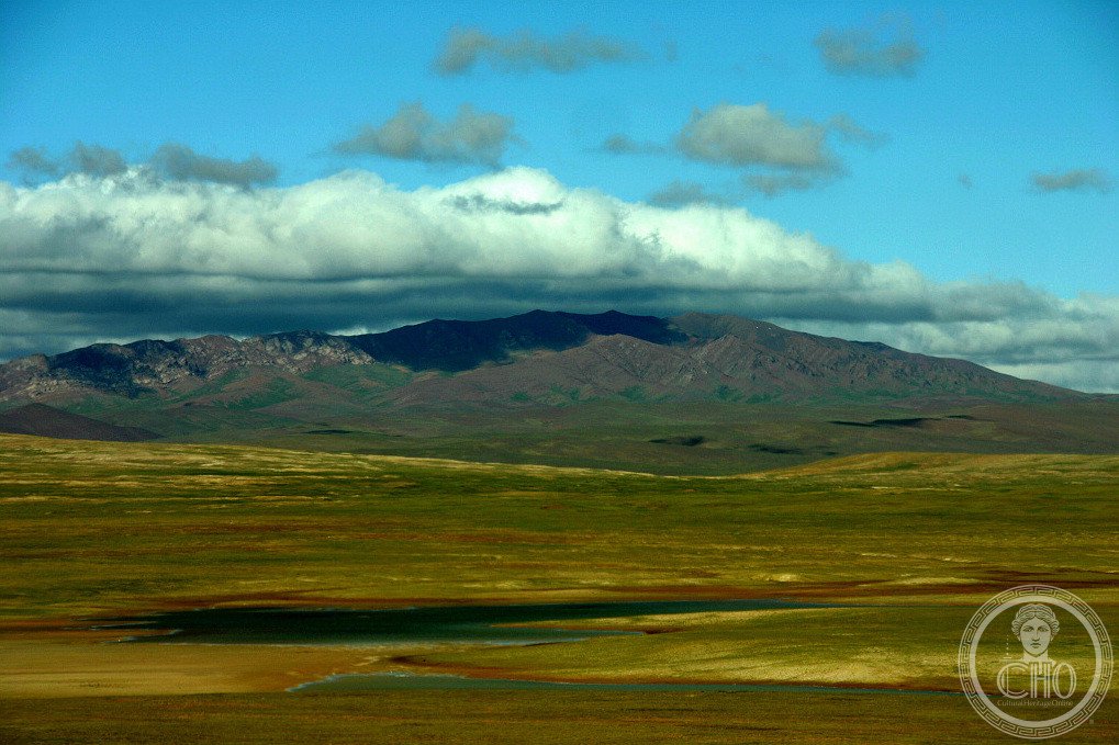
Hoh Xil (Kekexili in Mongolian, meaning “beautiful girl” or “green hills”) is a vast wilderness in Qinghai province, north-eastern Tibet, covering 3.735 million hectares at an average elevation of 4,500 metres — the largest and highest plateau on Earth. Almost uninhabited by humans, the area is characterised by permafrost, wetlands, salt lakes and alpine steppe. It is the critical breeding ground and migratory corridor of the Tibetan antelope (Pantholops hodgsonii, or chiru), whose population — poached to near-extinction in the 1990s — has recovered to over 70,000 animals thanks to strict protection. UNESCO inscribed Hoh Xil in 2017.
Key facts
- UNESCO: World Heritage since 2017 (Hoh Xil, ref. 1540)
- Area: 3.735 million hectares — one of the world’s largest protected natural areas
- Elevation: average 4,500 m; highest peaks above 6,000 m
- Tibetan antelope: chiru population recovered to 70,000+ after severe poaching in the 1990s
- Permafrost: continuous permafrost underlies the plateau; lakes and wetlands abundant
- Isolation: one of the least-accessible large wilderness areas in Asia
History
For most of human history, Hoh Xil was visited only by nomadic Tibetans and their yaks. The region became internationally known in the 1990s when the Tibetan antelope (chiru) was brought to the brink of extinction by commercial poaching: the chiru’s wool (shahtoosh) was illegally exported to produce ultra-fine shawls sold in Europe and the USA, and poachers killed tens of thousands of animals annually. The population collapsed from around 1 million to fewer than 10,000 in Hoh Xil.
Jiesang Suonandajie, a Qinghai wildlife official, dedicated his life to stopping the poaching and was shot and killed by poachers in 1994. His story and death galvanised protection efforts: Hoh Xil Nature Reserve was established in 1995, and armed anti-poaching patrols began. The chiru population has since recovered dramatically, and the annual migration of pregnant females north to their calving grounds — across high passes and flooded rivers — is one of the great wildlife spectacles of Asia. UNESCO inscribed Hoh Xil in 2017 for its outstanding natural value.
What you see
Hoh Xil is a landscape of extraordinary emptiness: rolling golden-brown steppe, turquoise salt lakes, snow-capped peaks and vast skies. In early summer, thousands of female Tibetan antelopes migrate north in lines across the plateau to their calving grounds — one of the few large mammal migrations still intact in Asia. Wolf packs, Tibetan wild asses (kiang), brown bears and black-necked cranes inhabit the reserve.
The region is visible from the Qinghai–Tibet Railway and Highway, which pass along the eastern edge of the reserve. Wildlife — particularly chiru, kiang and wolves — can often be seen from the train or road.
Practical information
- Access: the Qinghai–Tibet Railway (Golmud to Lhasa) passes the reserve’s eastern edge — the best way to see the landscape
- Permits: foreigners require a Tibet Travel Permit for sections of the railway in TAR
- Interior: off-road access to the reserve interior is tightly restricted; permits required
- Best time: June–July for chiru migration; July–August for most accessible conditions
Getting there
The Qinghai–Tibet Railway passes the eastern edge of Hoh Xil between Golmud and Lhasa — the most spectacular train journey in Asia. By road, the Qinghai–Tibet Highway (G109) parallels the railway. Access to the reserve interior requires permits and 4WD. GPS (centre): 35.15° N, 91.00° E.
Nearby
- Qinghai Lake — China’s largest lake and major bird migration stopover, 400 km north-east
- Sanjiangyuan — the “Three-River Headwaters” national park, source of the Yellow, Yangtze and Mekong rivers
- Lhasa — the Tibetan capital with the Potala Palace (UNESCO), 800 km south-west by rail
Sources
- UNESCO World Heritage Centre — “Hoh Xil” (ref. 1540)
- Encyclopaedia Britannica — Kekexili (Hoh Xil)
- WWF China — Tibetan antelope (chiru) recovery documentation
Find it on the map
See this place and what’s around it →📷 Diventa un fotografo di Cultural Heritage Online
Condividi le tue foto dei luoghi: restano pubblicate con la tua firma come autore. Più vengono viste, più ti fai conoscere — e presto un concorso premierà le foto più apprezzate.
Accedi o registrati gratis per aggiungere una foto