Historic Centre of Zacatecas
The city that bankrolled the Spanish Empire for two centuries — the silver deposits of Zacatecas (discovered 1546) were the richest in the world and the revenues they generated financed Philip II’s wars in Europe and the construction of El Escorial; the wealth was reinvested locally in the most elaborate Churrigueresque Baroque facades in Mexico, carved in the distinctive rose-pink cantera stone of the Zacatecas mountains, and set along a single dramatic canyon that forms the city’s unique urban geography.
At a glance
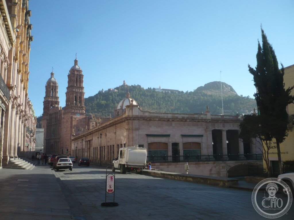
Zacatecas (population approximately 160,000) is the capital of Zacatecas State, north-central Mexico, at an altitude of approximately 2,440 m in the Sierra Madre Occidental mountain range, 650 km north-west of Mexico City. The city was founded in 1546 immediately after the discovery of the richest silver deposit in the world at the Cerro de la Bufa mountain (3,028 m, the hill that dominates the city); the canyon topography of the site (the city is built along the bottom and sides of a narrow mountain canyon with no flat land) gives Zacatecas its unique character among colonial Mexican cities — streets rise and fall steeply, buildings cling to cliff faces, and the Cathedral occupies the only level space at the canyon bottom. UNESCO inscribed the Historic Centre of Zacatecas in 1993.
Key facts
- Catedral de Zacatecas: the finest Churrigueresque Baroque façade in Mexico, and one of the finest in the world — built between 1730 and 1752 in the rose-pink cantera stone of the Zacatecas region; the façade (designed by Domingo Jiménez and Sebastián Coronado, then an anonymous master stonecutter from local workshops) is in the ultra-ornate Churrigueresque style (the Spanish and Mexican variant of Late Baroque in which every architectural surface is covered with densely packed sculptural ornament — saints, foliage, shells, cherubs, columns wrapped in vines — to the point where the underlying architectural structure becomes almost invisible); the west façade of Zacatecas Cathedral is consistently cited as the supreme example of the style in the Americas; the interior (five naves, rebuilt in the 19th century) is comparatively plain, so the full experience is exterior
- Cerro de la Bufa and the mines: the hill that defines Zacatecas — the Cerro de la Bufa (3,028 m, 500 m above the historic centre, accessible by aerial cable car — the teleférico de Zacatecas, the first cable car in Mexico, 1969) carries on its summit the Mausoleum of the Zacatecas Heroes, the sanctuary of the Virgin of the Patrocinio (a 17th-century pilgrimage church), and a panoramic platform with the most complete view of the colonial city and its canyon geography; the Mina El Edén (Eden Mine), the most important silver mine in the Zacatecas area during the colonial period (active 1586–1960s), is open to visitors with guided tours through the underground workings (the main shaft, 380 m underground, 3 km of tunnels); the mine also houses a disco (Bar El Mina, accessed through the mine entrance — claimed to be the deepest bar in the world)
- The pink cantera stone: the architectural material that gives Zacatecas its distinctive identity — a rose-pink volcanic tuff quarried from the Zacatecas mountains; the colour is caused by traces of iron oxide in the stone and ranges from pale blush to deep salmon depending on the quarry and the time of day (the buildings glow pink-orange at sunset in a particularly photogenic way); the stone is soft enough to carve in the elaborate detail required for Churrigueresque ornament and durable enough to survive the high altitude climate; the combination of the pink colour and the Churrigueresque carving quality gives Zacatecas its immediate visual identity among all Mexican colonial cities
- Rafael Coronel Museum: the most unusual museum in Mexico — the Rafael Coronel collection (housed in the restored ruins of a 17th-century Franciscan convent, with roofless cloisters where the collection spills across multiple floors) contains approximately 16,000 pre-Columbian ceramic masks (the largest collection of indigenous masks in the world), plus the original puppet and marionette collection of Diego Rivera’s daughter (Rivera was born in Guanajuato, the Zacatecas area was his grandmother’s homeland), and an extraordinary collection of pre-Columbian art from the Mexican west coast; the museum is typically deserted except for a few visitors and the experience is unusually intimate for a collection of this importance
- The Battle of Zacatecas (1914): the decisive battle of the Mexican Revolution — on 23 June 1914, the rebel general Francisco “Pancho” Villa led his División del Norte (30,000 men) in a direct assault on the federal garrison of 12,000 troops defending the Cerro de la Bufa; the battle (12 hours) resulted in a complete rebel victory and the destruction of the Federal Army as an effective fighting force; it was the largest and most violent single battle of the Revolution; the Mausoleum of the Zacatecas Heroes on the Cerro de la Bufa commemorates the battle and contains the remains of the rebel commanders; a re-enactment is held annually on 23 June
- Heritage: UNESCO World Heritage Site, Historic Centre of Zacatecas, inscribed 1993
- GPS: 22.7709° N, 102.5733° W
History
Three Spanish soldiers (Juan de Téllez, Juan de Zaldívar, and Cristóbal de Oñate) discovered the silver deposits of the Cerro de la Bufa in September 1546 during a military expedition against the Chichimec indigenous peoples of the region; within months, a mining camp had grown into a town; the silver production of Zacatecas exceeded all other mines in the world within two decades; by 1600, Zacatecas was producing approximately one-third of all the silver in the Spanish Empire; the wealth was used to build churches, convents, and palaces, and to attract the Jesuits, Franciscans, Dominicans, and Augustinians who built the religious complexes that define the historic centre. The silver production financed Philip II’s military campaigns in Europe, the construction of El Escorial (1563–84), and the Spanish Armada (1588); the economic connection between Mexican silver and European geopolitics was direct.
The mines were operated using a brutal system of forced indigenous labour (the repartimiento, later replaced by enslaved African labour for the underground work); the Chichimec War (1550–1590), a prolonged conflict between the Spanish colonists and the nomadic Chichimec peoples of the north, was in large part a conflict over control of the silver route from Zacatecas to Mexico City (the Camino de la Plata, Silver Road). After independence from Spain (1821), the mines were taken over by Mexican and British companies; Zacatecas became a battleground in both the War of Reform (1858–60) and the Mexican Revolution (1910–20), with the Battle of Zacatecas (1914) being the climactic military event of the Revolution.
What you see
The historic centre is compact and built along the canyon floor (the Callejón de la Cebada and the surrounding streets form the core); the Cathedral façade is best seen at sunrise (when the pink stone glows in direct east light) or at sunset (when the west-facing façade catches the last light); the teleférico (cable car from the Cerro del Grillo terminal, 10 min from the Cathedral) crosses the canyon to the Cerro de la Bufa in 7 minutes and gives the only aerial view of the city; the Mina El Edén tour (2h, departs from the mine entrance on Avenida Torreon, guided tour in Spanish with English translation, approximately MXN 100 pp) is the most unusual heritage experience.
The Callejón del Estudiante (the narrow alley connecting the Cathedral to the Plazuela de García) is the most atmospheric street in the city; the evening tascas (small bar-restaurants serving caldo (beef broth), gorditas, and mezcal) along this alley are where Zacatecas’s evening social life concentrates. The Feria Nacional de Zacatecas (early September, two weeks) is Mexico’s most important regional fair — bullfighting, cockfighting, traditional charreada (Mexican rodeo), and the Tamborazo music of the Zacatecas brass bands fill the city for two weeks.
Practical information
- Admission: Cathedral exterior and plaza free; interior free during services; Mina El Edén approximately MXN 100 (about €5); Rafael Coronel Museum approximately MXN 30 (about €1.50); Pedro Coronel Museum (the other major collection, in a former Jesuit college —19th and 20th century art including Goya, Hogarth, and Picasso prints) approximately MXN 30; teleférico approximately MXN 85 return; Cerro de la Bufa summit free (accessible by road or on foot from the cable car)
- Getting there: General Leobardo C. Ruiz International Airport (ZCL) — direct domestic flights from Mexico City (Aeroméxico, VivaAerobus, 1.5h, multiple daily), Guadalajara (1h), Monterrey (1h), Tijuana (2.5h); the airport is 25 km from the historic centre (taxi approximately MXN 250, 30 min); by first-class bus from Mexico City (ETN or Primera Plus, 7–8 hours, approximately MXN 600) — overnight bus service available; the bus terminal is 2 km from the historic centre
- Altitude and climate: at 2,440 m, Zacatecas has a mild semi-arid climate; temperatures are cool year-round (average maximum approximately 20°C, minimum approximately 6°C), with warm sunny days and cold nights; the dry season (November–April) is the best time to visit; the rainy season (June–September) brings afternoon thunderstorms but also the dramatic storm light that intensifies the colour of the cantera stone
Getting there
Zacatecas Airport (ZCL): 25 km from centre, flights from Mexico City (1.5h). Bus from Mexico City (7–8h). Altitude 2,440m. GPS: 22.7709, -102.5733.
Nearby
- Guadalupe Sanctuary — 3 km east of the Zacatecas historic centre (10 min by taxi); the Franciscan convent of Guadalupe (founded 1707 — the most important training college for Franciscan missionaries in northern Mexico and the south-western United States) contains the Museo de Guadalupe (the finest collection of New Spain Baroque religious painting in northern Mexico, with works by Antonio de Torres, Miguel Cabrera, and other Viceregal masters; approximately 150 major works in the sacristy and gallery spaces); the convent’s church façade is a smaller-scale example of the same Churrigueresque style as the Zacatecas Cathedral
- San Luis Potosí historic centre — 190 km south of Zacatecas (2.5h by bus); another major colonial silver-mining city, with the Plaza de Armas, the Cathedral, and the pink-and-grey local stone (the cantera de San Luis, slightly different from the Zacatecas pink) forming a coherent colonial centre; notable for the Mask Museum and the Teatro de la Paz, and as the origin of the Huasteca Potosina ecological corridor (waterfall and jungle landscape of the Sierra Madre Oriental accessible by day trip)
- Jerez de García Salinas — 55 km west of Zacatecas (1h by bus); a well-preserved small colonial town (not UNESCO-listed but often cited alongside Zacatecas for its intact colonial streetscape) famous for its jarabe dance tradition and the Toma de Zacatecas re-enactment; the weekly market on Sunday is one of the best regional craft markets in northern Mexico
Sources
- Wikipedia, Zacatecas City; Cathedral of Zacatecas; Battle of Zacatecas (1914), accessed June 2026
- UNESCO, Historic Centre of Zacatecas, WHS reference 676, inscribed 1993
- Jaime Olveda, Zacatecas: ciudad en el tiempo, El Colegio de Jalisco, 2004
- Peter Bakewell, Silver Mining and Society in Colonial Mexico: Zacatecas 1546–1700, Cambridge University Press, 1971
Find it on the map
See this place and what’s around it →📷 Diventa un fotografo di Cultural Heritage Online
Condividi le tue foto dei luoghi: restano pubblicate con la tua firma come autore. Più vengono viste, più ti fai conoscere — e presto un concorso premierà le foto più apprezzate.
Accedi o registrati gratis per aggiungere una foto