Isola di Henderson (sito naturale): l’atollo corallino sollevato più pristino del Pacifico, con quattro specie di uccelli endemici
A 5.000 chilometri dalla Nuova Zelanda e dalla costa sudamericana, nell’immenso Pacifico centrale dove le correnti oceaniche non portano detriti umani — o meglio, non portavano — l’isola di Henderson è il più grande atollo corallino sollevato del Pacifico. Il suo calcare corallifero, sollevato dal mare da movimenti tettonici, ospita una foresta costiera unica al mondo, quattro specie di uccelli che esistono solo qui (il rallo di Henderson, i tre fringuelli di Henderson), e una barriera corallina quasi inviolata. Patrimonio UNESCO dal 1988. Tristemente nota anche per una delle più grandi concentrazioni al mondo di plastica oceanica sulle sue spiagge inaccessibili.
At a glance
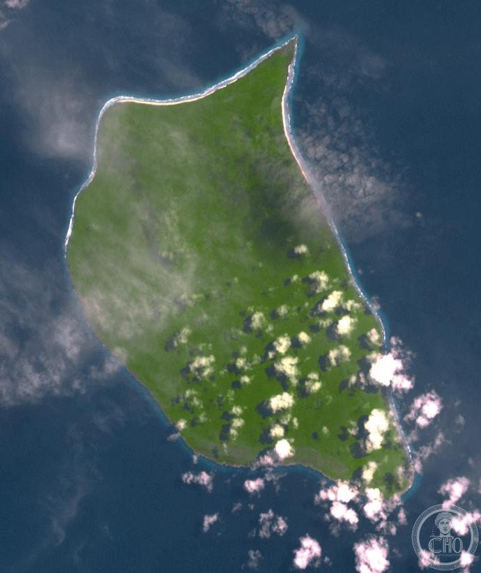
Henderson Island is an uninhabited raised coral atoll in the Pitcairn Islands group in the south-central Pacific Ocean, a UK Overseas Territory. It is one of the most remote islands on Earth — 192 km from the inhabited island of Pitcairn (pop. ~45), the nearest settlement. UNESCO inscribed it in 1988 (ref. 487) for its outstanding natural values as the best example in the world of an island whose ecology has been largely unaffected by the human presence. It has 94 recorded plant species (nine endemic), four endemic bird species and extraordinary marine biodiversity around its barrier reef. The island has gained recent notoriety as a recipient of enormous quantities of ocean plastic debris, despite its complete remoteness.
Key facts
- UNESCO: World Heritage since 1988 (Henderson Island, ref. 487)
- Type: raised coral atoll; limestone formed from ancient coral reef, uplifted by underlying Pacific Plate volcanic hotspot
- Endemic birds: Henderson reed warbler, Henderson fruit dove, Henderson lorikeet, Stephen’s lorikeet (though last confirmed sighting 1950s) — 4 birds found nowhere else
- Plants: 94 species of vascular plants; 9 endemic; dense limestone forest with Pisonia trees
- Marine: barrier reef with over 200 species of coral fish; green turtles nest on beaches
- Plastic pollution: a 2017 survey found ~37.7 million pieces of plastic debris on the island — the highest density ever recorded on any beach; a product of ocean currents converging
History
Henderson Island was inhabited by Polynesian settlers between approximately 800 and 1450 AD — likely an outpost of the Mangareva population to the west. Archaeological evidence includes stone tools, fish bones and bones of now-extinct bird species (the Polynesian settlers hunted several bird species to extinction). The island was abandoned around 1450 AD, probably due to the collapse of the Mangareva trading network, and was left uninhabited when Europeans arrived.
The British navigator James Henderson discovered the island for Europeans in 1819. The island is occasionally visited by Pitcairners for timber. A 2017 expedition to assess the plastic pollution found the situation alarming: despite being 5,000 km from the nearest major city, the South Pacific Gyre deposits 3,500 new pieces of plastic per day on the beaches. UNESCO has included plastic pollution in its assessment of the site’s integrity. The island is uninhabited, and landing on it from the sea is extremely difficult due to the surf.
What you see
Henderson Island has four distinct beach areas on its perimeter (north, south, east, west). The interior is dense, impenetrable limestone forest of Pisonia grandis, Pandanus and numerous smaller species. The cliff edges drop straight to the sea or to fringing reef. The coral formations are among the most pristine in the Pacific; fish populations are exceptionally dense due to the absence of fishing pressure.
The four endemic birds — the Henderson reed warbler, Henderson fruit dove, Henderson lorikeet and Henderson crake — are present throughout the island. The fruit dove’s plumage is one of the most vivid in the Pacific; the lorikeet is a brilliant green.
Practical information
- Access: essentially inaccessible to independent travellers; the only approach is from Pitcairn Island by small boat (192 km in open ocean); landing is subject to sea conditions
- Pitcairn: the only inhabited island in the group; reached by cargo ship from New Zealand (5–6 days) or French Polynesia; tourist visits arranged through the Pitcairn Islands Tourism office
- Scientific expeditions: must be authorised by the Pitcairn Island Council
- Henderson Island Plastic Survey: well documented in scientific literature; a reminder that no place is truly remote from human impact
Getting there
To Pitcairn: cargo ships from Auckland (NZ) or from Mangareva (French Polynesia) call at Pitcairn irregularly; the island’s only harbour is Bounty Bay. To Henderson from Pitcairn: by longboat in calm conditions (192 km; 1 day). GPS: 24.38° S, 128.32° W.
Nearby
- Pitcairn Island — the famous refuge of the Bounty mutineers (1790); one of the world’s smallest autonomous territories (45 residents); Bounty Bible and anchor on display
- French Polynesia — the nearest major island group, 1,700 km north-west; gateway to Mangareva and the Gambier Islands
- Easter Island (UNESCO) — the other great remote Pacific island, 2,000 km east; home of the moai statues
Sources
- UNESCO World Heritage Centre — “Henderson Island” (ref. 487)
- Jennifer Lavers et al. — “Plastic accumulation on Henderson Island”, PNAS (2017)
- Encyclopaedia Britannica — Pitcairn Island; Henderson Island
Find it on the map
See this place and what’s around it →📷 Diventa un fotografo di Cultural Heritage Online
Condividi le tue foto dei luoghi: restano pubblicate con la tua firma come autore. Più vengono viste, più ti fai conoscere — e presto un concorso premierà le foto più apprezzate.
Accedi o registrati gratis per aggiungere una foto