
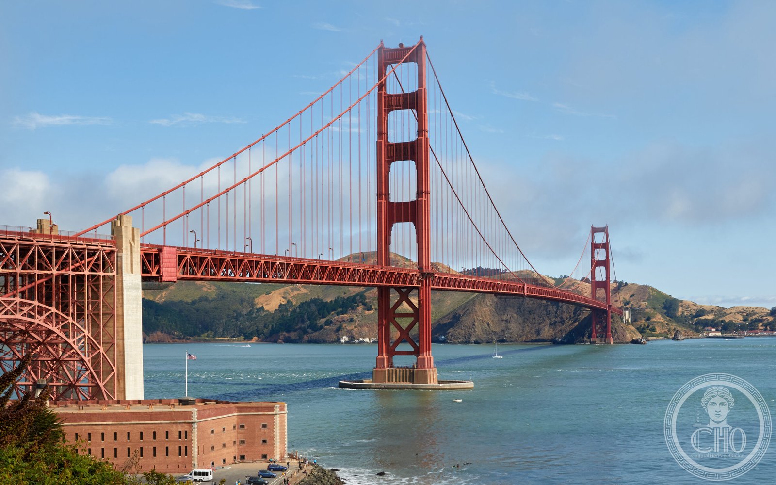
The world’s longest suspension bridge at its completion in 1937, its Art Deco towers were the work of architect Irving Morrow — as was the defining international orange paint that makes the bridge read through the bay’s perpetual fog.
At a glance
The Golden Gate Bridge spans 1.7 miles (2.7 km) across the strait connecting San Francisco Bay to the Pacific Ocean. Completed in 1937 after four years of construction, it held the title of the world’s longest suspension bridge for twenty-seven years. Chief engineer Joseph Baermann Strauss took public credit, but the structural mathematics were largely the work of Charles A. Ellis, while Irving F. Morrow gave the towers their distinctive Art Deco profile — replacing the expected lattice cross-bracing with fluted horizontal bands — and chose the bridge’s defining international orange color, reasoning that it would harmonise with the headlands and remain visible through the characteristic bay fog.
- Completed: 1937
- Main span: 4,200 feet (1,280 m)
- Tower height above water: 746 feet (227 m)
- Total length: 8,981 feet (2.7 km)
- Art Deco styling: Architect Irving F. Morrow
- Structural design: Charles A. Ellis
- National Historic Landmark: 1987
Key facts
- Construction start: January 5, 1933
- Opening day: May 27, 1937 (pedestrians); May 28, 1937 (vehicles)
- Construction cost: $35 million
- Clearance above water: 220 feet (67 m) at high tide
- Wire in each cable: 27,572 individual wires; 80,000 miles of total wire
- Paint: International Orange — continuously applied, never entirely complete
- Safety record: 11 deaths during construction; 19 lives saved by the pioneering safety net
History
The Golden Gate Strait — named by explorer John C. Frémont in 1846 from its resemblance to the Golden Horn at Constantinople — had long been considered uncrossable by practical engineering. The powerful tidal currents, the frequent earthquakes, the persistent fog, and the depth of the water below all argued against a bridge. Joseph Strauss, who had built hundreds of smaller bridges across America, championed the crossing from 1919 onwards, assembling a coalition of Bay Area counties behind the project and lobbying for years against the objections of the Southern Pacific Railroad and the United States War Department, both of which feared that a bridge would interfere with their interests.
Construction began on January 5, 1933, at the height of the Great Depression, employing an average of one thousand workers at any given time. Strauss introduced safety innovations that were radical for the era: hard hats were required on site, and a safety net was strung below the entire length of the construction zone — at a cost of $130,000, a considerable sum in 1933. The net saved nineteen men during construction; they organised themselves as the informal “Half Way to Hell Club.” Eleven workers were killed overall, principally in a single accident in February 1937 when a scaffold fell through the net.
The bridge opened on May 27, 1937, for pedestrians only. More than 200,000 people walked across on that first day; vehicle traffic began the following morning. On opening day the bridge was briefly the longest and tallest suspension bridge in the world. It held both records until 1964, when the Verrazzano-Narrows Bridge in New York City took the length title.
What you see
Irving Morrow transformed what could have been a purely functional structure. Rather than the lattice cross-bracing standard in industrial bridges, Morrow specified vertical fluting on the tower legs — interrupted by horizontal setbacks at regular intervals — giving the towers the Art Deco rhythm of a contemporaneous skyscraper. The proportions were carefully calibrated against the scale of the strait: each tower is 746 feet tall, and the two towers are spaced 4,200 feet apart, a ratio that keeps the main span reading as a single unified gesture rather than a mechanical interval between structural points. Morrow also designed the Art Deco light standards that line the roadway and the pedestrian railings that frame the views from the walkway.
The international orange paint — officially called “International Orange” — was Morrow’s choice from the beginning. When the structural steel arrived from the mill already coated in a red-orange primer, Morrow recognised that the color harmonised with the warm tones of the Marin Headlands and the rust of the Presidio’s brick fortifications, while standing in maximum contrast to the blue-grey water and fog. The Navy had wanted the bridge painted in alternating black and yellow stripes; the Army Air Corps had suggested red and white. Morrow prevailed. Maintenance crews repaint sections of the bridge on a continuous rotation; the bridge is never entirely unpainted at any given moment.
Practical information
- Vehicle toll: Southbound only; paid electronically via FasTrak or licence plate billing
- Pedestrians: East sidewalk open daily 5 am – 6 pm (extended hours seasonally); free of charge
- Cyclists: East sidewalk during pedestrian hours; west sidewalk at all other times
- Dress: A windbreaker is essential; the bridge is exposed and temperature drops significantly on the span
- Best viewing point: Battery Spencer in the Marin Headlands (north side) for the classic head-on view
- Time needed: Walking across and back takes approximately 90 minutes
Getting there
The bridge is at the northern edge of San Francisco, accessible via US-101 from both San Francisco and Marin County. The Golden Gate Bridge Welcome Center on the San Francisco side has parking (fee applies). Public transport: Muni bus 28 and GoldenGate Transit buses cross the bridge from the Salesforce Transit Center in downtown San Francisco. The nearest BART station is Civic Center / UN Plaza, approximately 4 miles from the south anchorage — connect by Muni bus 19, 47, or 49.
Nearby
- Fort Point National Historic Site — The only US military fort west of the Mississippi constructed in the Civil War era, built into the south anchorage of the bridge between 1853 and 1861. The bridge was redesigned by Morrow to arch over it rather than demolish it.
- Marin Headlands — Former military reservation north of the bridge with WWII-era gun emplacements and the panoramic Battery Spencer viewpoint.
- Muir Woods National Monument — Old-growth coastal redwood forest 12 miles north, accessible via Sir Francis Drake Boulevard from US-101.
- Alcatraz Island — Former federal penitentiary (1934–1963) in San Francisco Bay, visible from the bridge walkway; ferry from Pier 33.
Sources
- National Park Service, Golden Gate National Recreation Area — Bridge historical overview
- NRHP / National Historic Landmark nomination, Golden Gate Bridge, 1987
- Strauss, Joseph B. “The Golden Gate Bridge: Report of the Chief Engineer.” San Francisco: Golden Gate Bridge and Highway District, 1938
- Van der Zee, John. The Gate: The True Story of the Design and Construction of the Golden Gate Bridge. Simon & Schuster, 1986
- Golden Gate Bridge, Highway and Transportation District — official engineering specifications
Find it on the map
See this place and what’s around it →📷 Become a Cultural Heritage Online photographer
Share your photos of places: they stay published under your name as the author. The more they're seen, the more you get noticed — and soon a contest will reward the most appreciated photos.
Log in or sign up free to add a photoIs this page about you?
This page is read by travellers and heritage enthusiasts who find it on Google. Tell us how you are connected to this place and we will take it from there.