
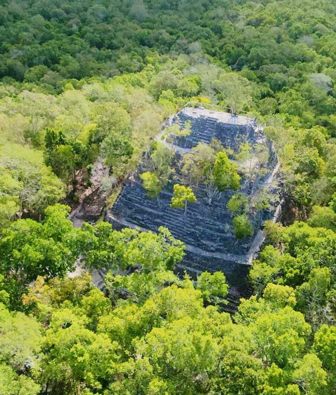
El Mirador
The Jungle City That Built the World's Largest Pyramid — and Was Forgotten for 1,500 Years
Overview
El Mirador is a ruined Preclassic Maya city buried deep in the jungle of northern Guatemala's Petén department, accessible only after a two-day trek through 43 kilometres of dense rainforest — or by helicopter. It is the most significant Maya city of the Preclassic period (roughly 600 BC to 150 AD), predating by a full thousand years the Classic Maya cities that most visitors associate with Maya civilization: Tikal, Palenque, Chichen Itza. At its heart stands La Danta, a massive triadic pyramid complex with an estimated volume of 2.8 million cubic metres — making it, by volume, the largest pyramid on Earth. The Great Pyramid of Giza contains approximately 2.6 million cubic metres of stone. El Mirador at its peak may have sustained a population of 100,000 people.
Location: Petén, Guatemala — 17.7568° N, 89.9252° W
La Danta: The Pyramid That Surpasses Giza
By volume, La Danta is the world's largest pyramid. The number bears repeating because it contradicts most popular understanding of ancient architecture: the pyramid complex at the heart of El Mirador contains an estimated 2.8 million cubic metres of material, compared to the Great Pyramid of Giza's 2.6 million cubic metres. (Cholula in Mexico is sometimes cited as even larger at 4.45 million cubic metres, but the bulk of that structure is a natural hill; the man-made component is considerably smaller.)
La Danta is a triadic pyramid: three pyramidal structures on a single elevated platform, a form characteristic of Preclassic Maya architecture. The base platform alone covers roughly 18 hectares. The total height from the base of the natural hill to the apex of the main temple is approximately 72 metres — taller than a 20-storey building — making it also one of the tallest pyramids ever built. All of it was constructed without metal tools, the wheel, or draft animals.
In 2009, archaeologists working at La Danta discovered a remarkable carved stucco frieze depicting the Maya Hero Twins, Hunahpu and Xbalanque, protagonists of the Popol Vuh creation narrative. Dating to roughly the 3rd century BC, this is among the oldest known narrative depictions in Maya art — predating the elaborately carved stelae of the Classic period by several centuries.
A City Before Its Time: The Preclassic Maya
El Mirador flourished during the Middle and Late Preclassic period, from approximately 600 BC to 150 AD. When El Mirador was building colossal pyramids and sustaining a population that may have numbered in the tens of thousands, the better-known Classic Maya cities had not yet been founded. Tikal did not reach its apogee until approximately 500–900 AD — six centuries after El Mirador had already been largely abandoned.
The El Mirador complex encompasses at least 35 triadic pyramid groups and a network of 26 raised causeways (sacbeob) connecting El Mirador to neighbouring cities including Nakbé, Tintal, and Xulnal. The sacbeob are up to 6 metres high, 20–50 metres wide, and extend for tens of kilometres through the jungle — infrastructure at a scale that would not be replicated in Mesoamerica for centuries.
Collapse: When Civilisation Cleared Its Own Forests
Around 150 AD, El Mirador was largely abandoned. The probable cause was ecological: centuries of intensive agriculture and large-scale construction had stripped the surrounding forests. Deforestation in a tropical karst environment leads rapidly to soil erosion, reduced water retention, and ultimately drought. A civilisation that had built the world's largest pyramid found itself unable to feed its population.
The jungle reclaimed the pyramids so completely that for more than 1,500 years they were indistinguishable from natural hills. When British cartographer Ian Graham first documented the site in 1962, he found structures so overgrown that their true scale was invisible from ground level. It was only through aerial survey and systematic excavation that the full extent of the complex became clear.
Discovery and the Battle for Protection
El Mirador was first formally documented by Ian Graham in 1962. Systematic excavation began in 1978 under Richard Hansen of the FARES Foundation (Foundation for Anthropological Research and Environmental Studies), who has directed work at the site for over four decades.
Hansen has simultaneously fought to protect El Mirador from logging, agricultural clearing, and looting. Despite its scale and significance, the site has no road access — a fact that frustrates researchers but inadvertently protects the ruins. Hansen has long advocated for a UNESCO-designated protected zone. The Maya Biosphere Reserve was established in 1990, but El Mirador itself has not yet received individual UNESCO World Heritage Site inscription. The pressure from Guatemala's agricultural frontier remains intense, and looters with helicopter access have targeted unguarded structures repeatedly.
The View from La Danta
There is no road to El Mirador. The standard approach is a 43-kilometre trek from the village of Carmelita, requiring roughly two days each way through rainforest. Guided tours depart Carmelita, include jungle camping, and allow one to two days at the site itself. The trail passes through terrain shared with jaguars, tapirs, and spider monkeys.
Visitors who reach El Mirador and climb La Danta are rewarded with a view that extends across unbroken jungle canopy for hundreds of kilometres. On a clear day, the top of Tikal's tallest pyramid is visible on the southern horizon, 65 kilometres away — two of the greatest cities of the ancient Maya world, separated by a millennium of history, simultaneously visible from a single vantage point.
Visitor Information
- Access
- 43km jungle trek from Carmelita village (2 days each way) or helicopter from Flores
- Nearest Town
- Flores, Petén (starting point for guided tours and helicopter services)
- Best Season
- October–May (dry season); June–September rains make trails extremely difficult
- Guided Tours
- Mandatory; book through licensed agencies in Flores or Santa Elena
- UNESCO Status
- Within Maya Biosphere Reserve; individual WHS inscription pending
- Excavation
- FARES Foundation / Richard Hansen (ongoing since 1978)
Sources and Further Reading
- El Mirador — Wikipedia
- FARES Foundation — El Mirador Basin Project
- Graham, Ian (1967). Archaeological Explorations in El Peten, Guatemala. Middle American Research Institute, Tulane University.
Find it on the map
See this place and what’s around it →📷 Become a Cultural Heritage Online photographer
Share your photos of places: they stay published under your name as the author. The more they're seen, the more you get noticed — and soon a contest will reward the most appreciated photos.
Log in or sign up free to add a photo