
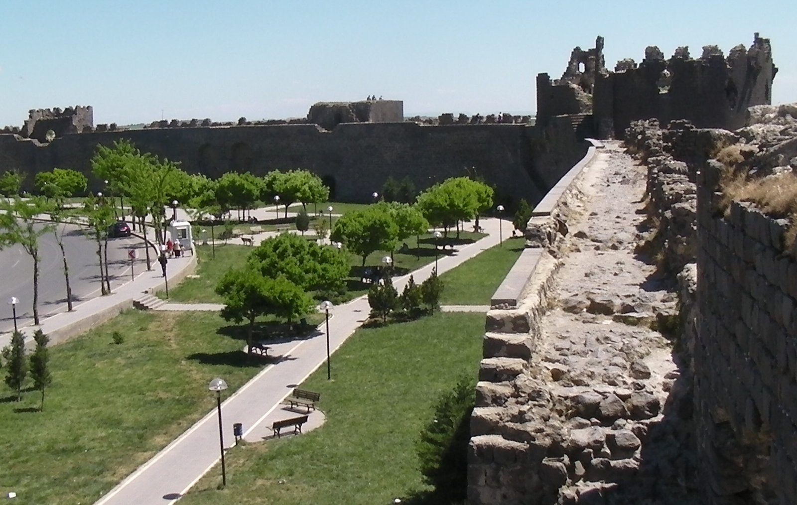
Two thousand years of living stone: the black basalt walls of Diyarbakir rank among the finest surviving Roman military fortifications on earth, enclosing a city that has been the cultural heart of the Kurdish people for centuries — and below them, the Hevsel Gardens have fed the city from the same Tigris floodplain for ten millennia.
At a glance
Diyarbakir Fortress and Hevsel Gardens Cultural Landscape was inscribed as a UNESCO World Heritage Site in 2015. The property combines two distinct but inseparable elements: the 5.8-kilometre rampart of black basalt that encircles the old city of Diyarbakir, and the 700-hectare agricultural landscape of the Hevsel Gardens in the bend of the Tigris River directly below the walls. Together they represent an unbroken thread of human settlement stretching from the Neolithic through the Roman, Byzantine, Arab, Artuqid, Safavid and Ottoman periods to the present day.
The city of Diyarbakir sits on a flat basalt plateau above the Upper Tigris Valley in southeastern Turkey. The walls are 10–12 metres high and 3–5 metres thick, constructed from the same dark volcanic basalt that defines the local landscape. The walls are considered the second longest basalt fortifications in the world after the Great Wall of China.
Key facts
- UNESCO inscription: 2015, Cultural Landscape
- Wall length: 5.8 km continuous circuit; 82 towers; 4 main gates
- Wall dimensions: 10–12 m high; 3–5 m thick; black basalt construction
- Original construction: 4th century CE (Roman), expanded by Byzantine, Umayyad and Artuqid rulers
- Inscriptions: Basalt blocks carved with texts in 18 languages including Greek, Armenian, Syriac and Arabic spanning 2,000 years
- Hevsel Gardens: 700 hectares, farmed continuously for approximately 10,000 years
- Great Mosque (Ulu Cami): 1091 CE, one of the oldest mosques in Anatolia, within the walled city
- Cultural significance: Symbolic and cultural capital of the Kurdish people
- Coordinates: 37.9131°N, 40.2281°E
History
The site of Diyarbakir has been inhabited since at least the Chalcolithic period. The Hevsel Gardens below the basalt cliffs have been farmed since Neolithic times, making the agricultural landscape one of the oldest continuously cultivated areas on earth. The Tigris River loops around the plateau on which the city sits, and the fertile gardens in the river bend provided a reliable food source that sustained permanent settlement long before the walls were built.
The Romans constructed the first stone circuit of fortifications in the 4th century CE, establishing the city — then known as Amida — as a major military outpost on the eastern frontier. Byzantine emperor Constantius II ordered a comprehensive rebuilding after the Persian siege of 359 CE. The walls were further reinforced and expanded by the Umayyad Arabs (7th–8th centuries), the Hamdanid dynasty, and most significantly the Artuqid dynasty, which made Diyarbakir their capital in the 12th and 13th centuries and enriched the walls with inscriptions and architectural elements from multiple traditions.
It was during the Artuqid and subsequent Seljuk and Ottoman periods that the extraordinary multilingual inscription tradition flourished. Rulers recorded their building campaigns, victories and acts of piety in Arabic, Persian, Syriac, Armenian, Greek and other languages — creating a palimpsest of political and cultural history carved directly into the basalt. The Ottoman empire took the city in 1515 CE.
In the modern era, Diyarbakir became the centre of Kurdish cultural and political life in Turkey. The UNESCO inscription in 2015 coincided with a period of heightened tension: the walled old city suffered significant damage during urban conflict in 2015–2016. Reconstruction and heritage conservation efforts have continued since.
What you see
The walls form a near-complete circuit around the old city, punctuated by 82 towers of varying form — round, square, polygonal — and four original Roman gates remodelled through the centuries: the Harput Gate (north), Mardin Gate (south), New Gate (east) and the Urfa Gate (west). Walking the full circuit takes approximately three hours at a comfortable pace; the views over the Tigris valley and Hevsel Gardens are particularly striking from the southern and eastern sections.
The tower surfaces and gate piers are covered in carved stone panels bearing hundreds of inscriptions in multiple scripts. Many are bilingual or trilingual, reflecting the successive rulers and the different communities — Kurdish, Arab, Armenian, Syriac Christian, Greek — who have lived within the walls. Look for animal reliefs, geometric patterns and names of rulers alongside Arabic Quranic verses and Armenian Christian dedications.
Within the walled city, the Great Mosque (Ulu Cami, 1091 CE) is built on the foundations of a Byzantine cathedral, which itself stood on an earlier Roman temple. The mosque preserves elements of all three buildings and is considered the earliest surviving example of Anatolian mosque architecture. The Hevsel Gardens are visible from the walls — a green ribbon of orchards, vegetable plots and mulberry trees along the river bend, still actively farmed.
Practical information
- Access: The old city (Suric district) is walkable; main entry to the wall walk is near the Harput Gate. Access to the walls is free.
- Best time: Spring (April–May) and autumn (September–October); summer reaches 35–40°C.
- Duration: Allow a full day: half for the walls and old city, half for the Hevsel Gardens and the Tigris riverside.
- Highlights inside the walls: Ulu Cami (Great Mosque), the Four-Legged Minaret, the Kasim Padisah Mosque, the Armenian Church of Surp Giragos (partially restored).
- Language: Turkish and Kurdish are both spoken; English is less common than in Istanbul.
Getting there
Diyarbakir has its own international airport (DIY), with direct flights from Istanbul (approximately 2 hours) and Ankara on Turkish Airlines and Pegasus. The airport is approximately 8 km from the old city; taxis and shared minibuses connect it to the centre.
By bus, Diyarbakir is connected to major Turkish cities via long-distance coaches; the journey from Ankara takes approximately 12 hours. Within the old city, all main sites are within walking distance of each other.
Nearby
- Cayonu Tepesi — 30 km northwest; one of the world’s earliest farming settlements (c. 7250–6750 BCE).
- Hasankeyf — approximately 100 km east on the Tigris; ancient cliff city with cave dwellings and a medieval bridge, now partially flooded by the Ilisu Dam.
- Lake Van and Akdamar Island — approximately 200 km east; the Armenian Church of the Holy Cross (915 CE).
- Gobek Tepe — approximately 175 km west near Sanliurfa; the world’s oldest known monumental architecture (c. 9500–8000 BCE).
Sources
- UNESCO World Heritage List: Diyarbakir Fortress and Hevsel Gardens Cultural Landscape (2015). whc.unesco.org
- Gabriel, Albert. Voyages archéologiques dans la Turquie orientale. Paris, 1940.
- Sinclair, T.A. Eastern Turkey: An Architectural and Archaeological Survey. Vol. 3. London: Pindar Press, 1989.
- Wikipedia: “Diyarbakir Fortress” — factual cross-check only.
Find it on the map
See this place and what’s around it →📷 Become a Cultural Heritage Online photographer
Share your photos of places: they stay published under your name as the author. The more they're seen, the more you get noticed — and soon a contest will reward the most appreciated photos.
Log in or sign up free to add a photo