Cuicuilco
The oldest pyramid in Mexico City — a circular platform mound of 500 BC buried under lava from the Xitle volcano, now surrounded by a shopping mall and the UNAM campus, yet still rising above the lava to reveal one of Mesoamerica’s least-known origin stories.
At a glance
In the southern borough of Tlalpan, Mexico City, the circular pyramid of Cuicuilco stands at the edge of the Pedregal de San Angel lava field — a Pre-Classic ceremonial centre that flourished from around 800 BC and was violently ended when the Xitle volcano erupted around 100 AD, burying much of the city under ten metres of lava. The pyramid’s upper stories still emerge above the hardened lava surface, making Cuicuilco one of the most visually striking — and most contextually surreal — archaeological sites in the Western Hemisphere: a 2,000-year-old monument whose summit offers views of a university campus and a shopping centre rather than open landscape.
Key facts
- Period: c. 800–100 BC (Pre-Classic Mesoamerican)
- Pyramid dimensions: approximately 100–120 m diameter, 18 m high; four construction phases in compacted earth faced with volcanic stone
- Form: circular — unique in Mesoamerican architecture, where virtually all other major pyramids are rectangular
- Population at peak: estimated 20,000 inhabitants, one of the largest settlements in the central Mexican highlands before the rise of Teotihuacan
- End date: Xitle volcano eruption, c. 100 AD — lava covered approximately 80 km2 of southern Valley of Mexico under an average 10 m of lava
- Buried portion: lower stories under lava; partially explored by tunnelling since the 1920s
- Administered by: INAH (Instituto Nacional de Antropologia e Historia); free admission
History
Cuicuilco emerged as a significant ceremonial and residential centre in the Valley of Mexico during the Early Pre-Classic period, perhaps as early as 1000 BC. By 400–200 BC it had grown into one of the most important cities in central Mexico, rivalling the early phases of Teotihuacan. Its principal monument was built in four successive construction phases over several centuries, each phase encasing the previous structure in a new shell of compacted earth and volcanic stone; the summit bore a fire altar documented by early excavations. The surrounding city covered several square kilometres, with dense residential zones, craft production, and agricultural terraces on the hillslopes above the valley floor.
The city’s catastrophic end came around 100 AD when the Xitle volcano erupted and produced a lava flow covering approximately 80 square kilometres of the southern Valley of Mexico under lava averaging 10 metres thick. The population fled northward; many are believed to have joined the growing city of Teotihuacan, whose dramatic rise to dominance of the Valley of Mexico coincides almost exactly with Cuicuilco’s destruction. The lava field that buried Cuicuilco — still visible today as the Pedregal de San Angel — preserved the archaeological deposits beneath in an undisturbed state for nearly two millennia.
Systematic excavations began in the 1920s under Manuel Gamio and continued intermittently through the 20th century. The lower stories of the pyramid have been explored by tunnelling through the lava. The full extent of the urban deposit remains largely unexcavated: estimates based on surface survey and sub-lava soundings suggest the buried area is enormous, but access is structurally limited by the hardened lava cap and the presence of UNAM and urban infrastructure directly above the buried city.
What you see
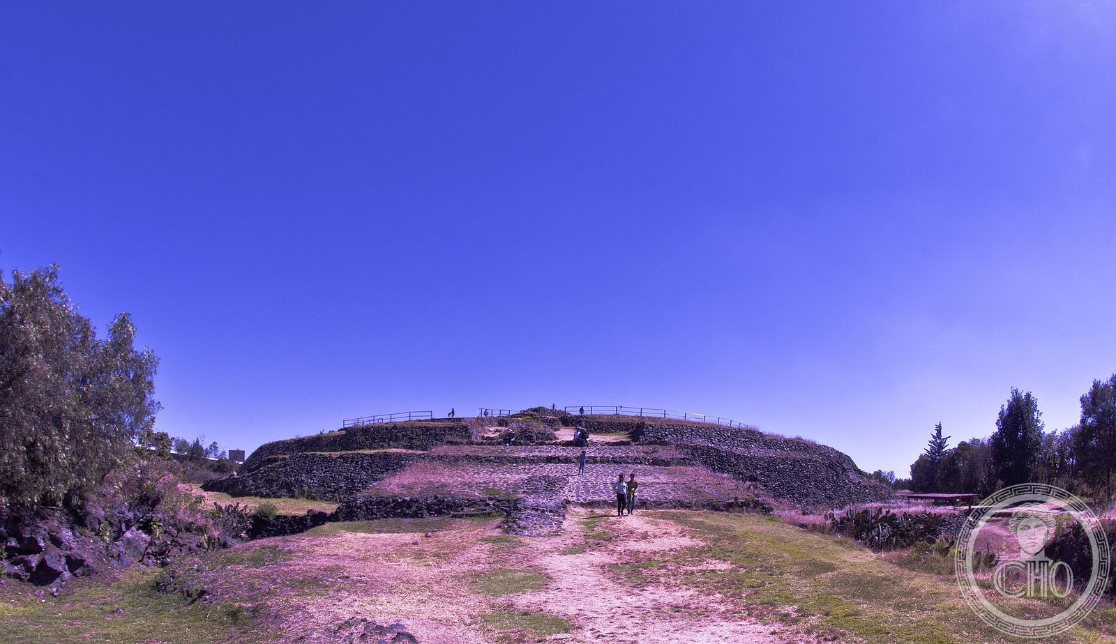
The surviving visible monument is the upper portion of the circular pyramid — four truncated terraces of rough volcanic stone rising from the lava surface to the summit platform. The form is immediately striking: unlike every other major pyramid in Mexico, Cuicuilco is circular in plan, approximately 100–120 metres across and approximately 18 metres above the current lava surface. Access to the summit is via a modern staircase on the south face. The summit platform is flat and open, with the remains of a circular fire altar at the centre. From the top the lava field extends southward and the UNAM campus northward, with the Perisur shopping centre visible to the east — a juxtaposition unique in world archaeology.
Around the base of the pyramid, the Pedregal de San Angel lava field is dramatically visible: a dark, jagged expanse of solidified basaltic lava from which the pyramid emerges like a geological island. A small site museum (Museo de Sitio de Cuicuilco) at the entrance contains ceramics, figurines, and scale models illustrating the city’s extent before the eruption, as well as material recovered from the tunnelled lower stories. The museum makes clear the extraordinary scale of what remains buried: the visible monument is only the tip of a much larger deposit sealed beneath one of the world’s largest cities.
Practical information
- Address: Insurgentes Sur s/n, Tlalpan, Mexico City (CDMX); adjacent to Periferico Sur and opposite Perisur shopping centre
- Opening hours: Tuesday–Sunday, 9:00–17:00; closed Mondays and national holidays
- Admission: free (INAH-administered national archaeological zone)
- On-site facilities: site museum, toilets, information panels; no cafe
- Accessibility: lower grounds wheelchair-accessible; pyramid summit involves steep stairs
- Time required: 1–2 hours including museum visit
Getting there
Cuicuilco is on Insurgentes Sur in Tlalpan, approximately 20 km south of the Mexico City centre. By Metro: take Line 3 to Universidad terminal, then Metrobus Line 1 south to Perisur or Cuicuilco stops (approximately 10 minutes). By car: exit Periferico Sur at Insurgentes; the site entrance is on Insurgentes Sur directly next to the Perisur shopping centre. Ride-sharing reaches the site easily. Metro plus Metrobus is recommended; Insurgentes Sur traffic can be severe during peak hours.
Nearby
- Pedregal de San Angel Ecological Reserve (UNAM): the lava field adjacent to Cuicuilco, now a protected ecological reserve within the UNAM campus with extraordinary endemic flora and guided visits available
- National Museum of Anthropology (Chapultepec): approximately 30 minutes north; holds major Cuicuilco ceramics and figurines, plus comprehensive Pre-Classic to Aztec collections
- Teotihuacan: approximately 50 km northeast; the city that rose to dominance of the Valley of Mexico following Cuicuilco’s destruction
- Tlalpan historic centre: 3 km south; colonial-era village centre with 17th-century church and local restaurants
Sources
- Niederberger, Christine. Paleopaysages et archeologie pre-urbaine du Bassin de Mexico. CEMCA, 1987 — foundational study of Pre-Classic Valley of Mexico including Cuicuilco stratigraphy
- Pastrana, Alejandro, and Irene Camara. “La Cuenca de Mexico durante el Preclasico.” Arqueologia Mexicana, vol. 14, 2006 — overview of Pre-Classic central Mexico including Cuicuilco
- INAH. Zona Arqueologica de Cuicuilco — Guia oficial de la zona. 2019 — chronology, architectural phases, site museum catalogue
- Siebe, Claus. “Age and archaeological implications of Xitle volcano, southwestern Basin of Mexico City.” Journal of Volcanology and Geothermal Research, vol. 104, 2000 — radiocarbon dating of the Xitle eruption
- Wikipedia contributors. “Cuicuilco.” Wikipedia, The Free Encyclopedia. Accessed 2026-06-11.
Find it on the map
See this place and what’s around it →📷 Diventa un fotografo di Cultural Heritage Online
Condividi le tue foto dei luoghi: restano pubblicate con la tua firma come autore. Più vengono viste, più ti fai conoscere — e presto un concorso premierà le foto più apprezzate.
Accedi o registrati gratis per aggiungere una fotoDo you manage this place?
This page is read by travellers and heritage enthusiasts who find it on Google. Keep it accurate — and make it work for you. Free for non-profit heritage institutions.