
Costiera Amalfitana — il Paesaggio Culturale delle Terrazze e dei Limoneti tra Positano e Vietri (X-XX sec.): la Costa più Famosa d’Italia (UNESCO 1997)
The Amalfi Coast — 50 km of limestone cliffs between Positano and Vietri sul Mare, terraced in dry-stone walls from the 10th century onward by the inhabitants of one of medieval Italy’s most powerful maritime republics — is inscribed by UNESCO not for any single monument but for the entire cultural landscape: the accumulated work of building lemons, vines, gardens, fishing villages, and medieval towers onto vertical rock faces in one of the most visually concentrated accumulations of human effort in the Mediterranean.
At a glance
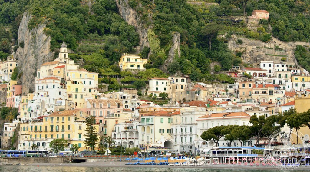
The Amalfi Coast (province of Salerno, Campania; UNESCO 1997, ref. 830) was one of the first Italian UNESCO inscriptions in the “cultural landscape” category — a designation that covers not a single building or site but a living landscape shaped by the continuous interaction of human communities and natural environment over centuries. The outstanding universal value recognized by the WHC is: (1) the dry-stone terracing system (muretti a secco), which converts near-vertical limestone cliffs into cultivable terraces for lemons (the Sfusato Amalfitano, the elongated local variety with thin edible rind, designated IGP), vines, and vegetables; (2) the medieval urban morphology of the coast’s villages (Positano, Praiano, Amalfi, Atrani, Ravello, Minori, Maiori, Cetara, Vietri), each of which follows a characteristic pattern of houses built vertically on the cliff face above a small harbour; and (3) the historical evidence of the Republic of Amalfi, the first of the four Italian maritime republics (Venice, Genoa, Pisa), which from the 9th to the 11th century controlled Mediterranean trade routes and introduced the nautical compass to Europe.
Key facts
- La Repubblica di Amalfi (IX-XI sec.): Amalfi was the first and (before Venice’s ascendancy) the most powerful of the four Italian maritime republics (Amalfi, Venice, Genoa, Pisa); at its peak (10th-11th century) it controlled trade between Byzantium, the Arab world, and the western Mediterranean; Amalfi merchants had their own trading colonies (fondachi) in Constantinople, Alexandria, Antioch, and North Africa; the Tavole Amalfitane (the maritime code compiled in Amalfi, c.1098-1130) was the standard maritime legal code for the entire Mediterranean for 500 years (until 1570); the Amalfi navigator Flavio Gioia is credited (though disputed) with introducing the magnetic compass to Europe in the early 14th century
- I muretti a secco (X sec. – oggi): The dry-stone terracing of the Amalfi Coast is one of the most extensive dry-stone terrace systems in Europe: approximately 3.5 million cubic metres of limestone blocks were assembled without mortar (dry-stone technique) from the 10th century to the 20th century to create the approximately 1,000 km of terracing that turns the coastal cliff face into cultivable land; the maintenance of the muretti a secco requires continuous skilled labour (the terrace walls require rebuilding after every major rainstorm event)
- Lo Sfusato Amalfitano IGP: The Sfusato Amalfitano is the indigenous lemon cultivar of the Amalfi Coast (recognized as IGP since 2001): elongated (sfusato = “tapered”), with a thin aromatic rind (the zest is the most valuable part), slightly sweet, high in vitamin C; used for limoncello (liqueur), pasta sauces, and fresh consumption; the lemon trees grow in the terrace gardens under the characteristic wooden pergola (pergolato) structures that shade the fruit from direct sun
- UNESCO: 1997, rif. 830
- GPS: 40.6339, 14.6024 — Google Maps (Amalfi, duomo e centro storico)
History
The Amalfi Coast was settled in antiquity (Roman villas along the coast are documented from the 1st century CE); the Republic of Amalfi rose to prominence in the 9th century, with its own doge (head of government) and a navy that dominated Mediterranean trade; the republic was conquered by the Normans in 1131 and incorporated into the Kingdom of Sicily; the Black Plague of 1343 and the destruction of the harbour (by a wave — possibly a tsunami) in the same year ended Amalfi’s commercial role definitively. The coast remained an agricultural backwater until the 19th century, when British and Northern European tourists (including John Ruskin, who wrote extensively about Amalfi, and the German Romantic painters of the Nazarene movement, who settled in nearby Positano) “discovered” the coast; by 1900 the coast had become one of Italy’s first tourist destinations. The Strada Statale Amalfitana (the coastal road, SS163, completed 1853) was a major engineering project carved into the cliff face and made the coast accessible for the first time by wheeled vehicles.
What you see
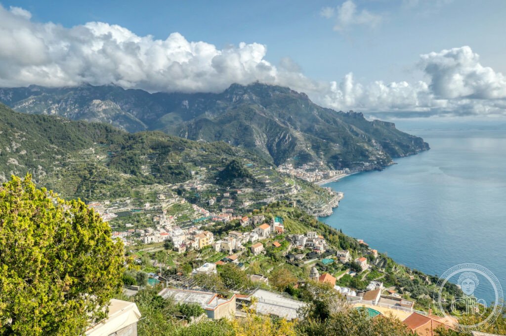
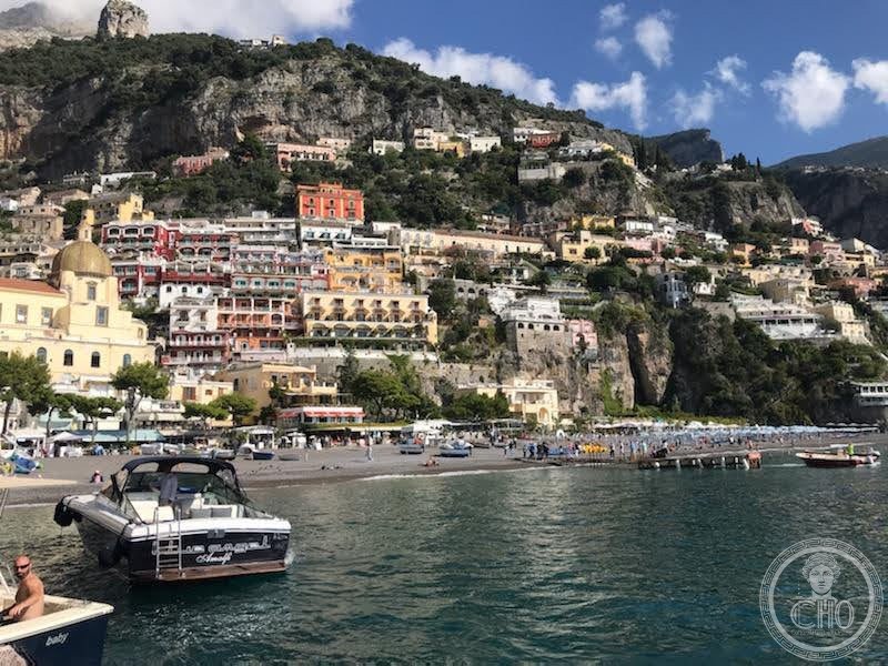
The Amalfi Coast is a 50 km linear landscape best experienced by two methods: the coastal road (SS163) and the path network (most significantly the “Sentiero degli Dei” — the Path of the Gods, a 7.8 km high-altitude traverse above Positano with views over the entire coast from Capri to Salerno; starting point at Bomerano/Agerola; rated “easy to medium,” allow 3-4 hours one-way, return by ferry). Primary urban stops: Positano (the most picturesque; the dome of Santa Maria Assunta with its majolica tiles; the ferry to Capri); Amalfi (the Duomo di Sant’Andrea, 9th-10th century, with the Arab-Norman cloister; the Museo della Carta, the 13th-century paper mill using the original hydraulic equipment); Ravello (25 min drive from Amalfi, 365 m altitude; the Villa Rufolo gardens with the view point used by Richard Wagner in 1880 as the setting for the “Klingsor’s Magic Garden” in Parsifal; the Villa Cimbrone, 11th century, with the “Terrace of Infinity” that Gore Vidal described as the most beautiful view in the world). Allow 2 full days minimum for the coast.
Gallery
Practical information
- Navigazione: SITA Sud buses run the SS163 from Salerno to Positano (1h30, frequent in summer; expect delays in peak season due to narrow road); ferry service connects Salerno, Vietri, Cetara, Minori, Maiori, Amalfi, Positano, and Capri (May-October, daily; check timetables at Navigazione Libera del Golfo or TravelMar). The ferry is generally faster and more pleasant than the bus in summer; the bus has winter service.
- Parcheggio: The SS163 has extremely limited parking; day visitors are best served by arriving by ferry (from Salerno or Naples) or by parking in Vietri sul Mare or Salerno and taking the bus. The ZTL (Limited Traffic Zone) applies in Positano for cars registered outside Campania from June-September.
- Sentiero degli Dei: Trail head at Bomerano (Agerola), accessible by SITA bus from Amalfi (direction Agerola-Bomerano, ~40 min); the trail ends at Nocelle (above Positano), with a steep descent to Positano (45 min) or a bus to Positano from Nocelle. Best done west to east (Bomerano to Nocelle) for the morning light on the sea.
Getting there
Amalfi (SA), Campania. GPS 40.6339, 14.6024. By ferry: from Naples (Molo Beverello) to Amalfi (~1h15, seasonal June-October); from Salerno to Amalfi (45 min, year-round). By bus: SITA Sud from Salerno (CSTP connection at Salerno FS station, ~1h15, year-round). By car: from Naples, A3 → Vietri sul Mare exit → SS163 coast road (2h in summer traffic); from Salerno, SS163 (30 min clear, 1h summer). Amalfi has almost no parking — approach by ferry or bus strongly recommended in season.
Nearby
- Pompei — 40 km north; the most-visited archaeological site in Italy (the Roman city buried by Vesuvius in 79 CE, with extraordinary preservation of streets, buildings, frescoes, and casts of the victims); UNESCO 1997
- Ravello — 7 km from Amalfi by mountain road; the hilltop town (365 m) with Villa Rufolo (11th century Norman-Arab garden, setting of Wagner’s Parsifal inspiration) and Villa Cimbrone (Terrace of Infinity); UNESCO nomination pending
- Isole di Capri — 45 min by ferry from Positano or Amalfi; the resort island with the Grotta Azzurra (Blue Grotto, underwater marine cave with iridescent blue light), the Villa Jovis (Emperor Tiberius’s retirement palace, 1st century CE), and the Via Krupp
Sources
- UNESCO: whc.unesco.org/en/list/830
- Wikipedia EN: Amalfi Coast
- Tavole Amalfitane: museodellarepubblicammarittimadicamaggioreasfalerna.it
Find it on the map
See this place and what’s around it →📷 Diventa un fotografo di Cultural Heritage Online
Condividi le tue foto dei luoghi: restano pubblicate con la tua firma come autore. Più vengono viste, più ti fai conoscere — e presto un concorso premierà le foto più apprezzate.
Accedi o registrati gratis per aggiungere una foto