Ciudad Perdida (Teyuna)
Older than Machu Picchu and hidden for centuries in a Colombian cloud forest, Teyuna — the Lost City of the Tairona — is one of the great pre-Columbian cities of the Americas, a terraced metropolis of 169 stone platforms reachable only by a four-to-six-day jungle trek.
At a glance
Ciudad Perdida (Spanish: “Lost City”), known in the Kogi language as Teyuna, sits at approximately 1,300 metres altitude in the Sierra Nevada de Santa Marta — the world highest coastal mountain range, rising from sea level to 5,775 metres within 45 km of the Caribbean. Built from around 650 AD by the Tairona civilisation — roughly 650 years older than Machu Picchu — the city at its height housed an estimated 2,000 to 8,000 people across a complex of 169 interconnected stone terraces, plazas, and circular platforms. Rediscovered by Western archaeology in 1972 and accessible only by multi-day jungle trek, it remains one of the most physically demanding and rewarding archaeological sites in the Americas.
Key facts
- Founded: c. 650 AD (Tairona civilisation)
- Peak population: 2,000-8,000 people
- Scale: 169 interconnected terraces and plazas
- Altitude: c. 1,300 m in the Sierra Nevada de Santa Marta
- Access: 4-6 day jungle trek, crossing the Buritaca River 30+ times
- Rediscovered: 1972 (guaqueros); formal excavation from 1975
- Indigenous custodians: Kogi, Wiwa, Arhuaco, and Kankuamo peoples
History
The Tairona were one of the most sophisticated pre-Columbian civilisations of South America: densely settled highland communities with advanced metallurgy, terrace agriculture, and stone architecture. They built Teyuna from around 650 AD as a major urban and ceremonial centre, connected to other Tairona settlements by a network of stone-paved paths. At its peak the city 169 terraces and plazas were home to thousands, all linked by a dramatic staircase of 1,200 steps climbing from the Buritaca Valley floor.
Spanish colonisers arrived from 1514 onward. The Tairona resisted fiercely and were never fully subjugated, but by 1600 epidemic disease and continuous warfare had reduced the population catastrophically. The settlements of the Sierra Nevada, including Teyuna, were abandoned to the forest and remained unknown to the outside world for more than three centuries.
In 1972, Colombian grave robbers following rumours of a lost city found the site and began looting its tombs. The sudden appearance of exceptional Tairona artefacts on the Bogota antiquities market alerted the Colombian Institute of Anthropology and History, which launched formal excavation in 1975. Today the Kogi, Wiwa, Arhuaco, and Kankuamo peoples — descendants of the Tairona — regard Teyuna as one of the heart places of the world and have negotiated partial ritual control over the site with the Colombian government.
What you see
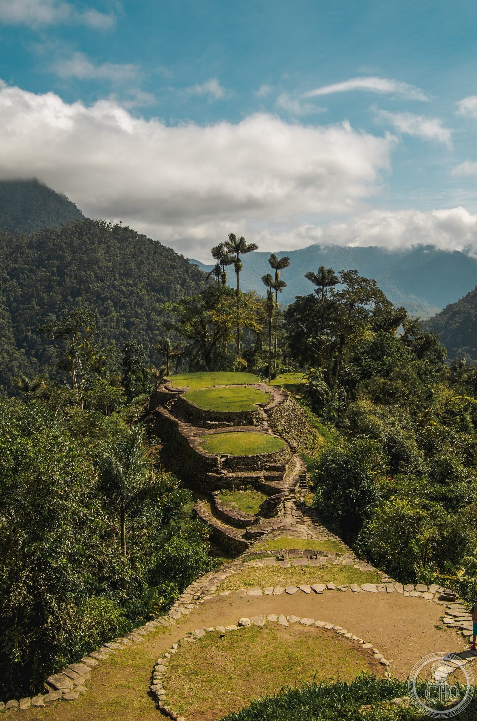
The city is built on 169 stone-cut terraces carved directly into the steep slopes of the Sierra Nevada, each connected by stone staircases. The main access from the valley is via the Great Staircase: 1,200 steps hewn from stone, ascending through dense cloud forest to the main plaza. The terraces supported circular stone foundations on which wooden and thatch structures once stood; their footprint rings are clearly visible throughout the complex. Drainage channels, retaining walls, and stone-lined paths run throughout the site.
The principal plazas at the heart of the complex hosted public ceremonies, trade, and political gatherings. Surrounding terraces include residential zones, agricultural platforms, and ceremonial areas marked by circular stone basins and carved stones. The entire site is embedded in subtropical cloud forest; the combination of stone architecture and jungle vegetation gives Ciudad Perdida a visual drama matched by very few archaeological sites in the Americas.
Practical information
- Access: Licensed guided multi-day trek only — no independent trekking permitted
- Duration: 4-6 days round trip (standard: 4 nights/5 days)
- Starting point: Machete Pelado village, c. 40 km from Santa Marta
- Operators: Several licensed agencies based in Santa Marta
- Best season: December-March and June-August (drier months)
- What to bring: Waterproof gear, river sandals for crossings, insect repellent
- Entry fee: Included in guided tour price; portion goes to indigenous communities
Getting there
Santa Marta on Colombia Caribbean coast is the gateway city, served by domestic flights from Bogota, Medellin, and Cartagena. Licensed tour operators in Santa Marta provide transport to the trailhead at Machete Pelado and guide the full 4-6 day circuit. The route crosses the Buritaca River more than thirty times and climbs through tropical forest to the site entrance.
Nearby
- Tayrona National Park — coastal jungle reserve 35 km west with Tairona archaeological sites and Caribbean beaches
- Santa Marta — Colombia oldest surviving European city (founded 1525); Museo del Oro Tairona
- Palomino — small beach town at Sierra Nevada foothills, gateway to Kogi community visits
- Cartagena — UNESCO-listed colonial port, 200 km west
Sources
- Langebaek, C.H. (2019). The Archaeology of Colombia. Cambridge University Press.
- Reichel-Dolmatoff, G. (1965). Colombia. Thames and Hudson.
- Instituto Colombiano de Antropologia e Historia (ICANH) — official site documentation.
- Wikipedia contributors, Ciudad Perdida, Wikipedia (retrieved 2026).
- UNESCO World Heritage tentative list — Sierra Nevada de Santa Marta.
Find it on the map
See this place and what’s around it →📷 Diventa un fotografo di Cultural Heritage Online
Condividi le tue foto dei luoghi: restano pubblicate con la tua firma come autore. Più vengono viste, più ti fai conoscere — e presto un concorso premierà le foto più apprezzate.
Accedi o registrati gratis per aggiungere una foto