City of Potosí
The mountain that built the modern world economy — Cerro Rico (“Rich Mountain”), the conical peak above Potosí, Bolivia, was discovered to contain the richest silver deposits on earth in 1545; by 1650 the city at its base (4,000 metres above sea level, one of the highest cities in the world) had a population of 200,000 — larger than Paris — and had produced more silver than the rest of the world combined; the expression “vale un Potosí” (worth a Potosí) entered the Spanish language as the measure of incomparable wealth, and the silver peso minted here became the world’s first global currency.
At a glance
Potosí (altitude 3,967 m, population approximately 225,000) is the capital of the Potosí Department of south-western Bolivia, situated at the foot of the Cerro Rico (“Rich Mountain”) in the Bolivian Altiplano, approximately 470 km south of La Paz. The city was founded in 1545, immediately after the discovery of silver in the Cerro Rico by Diego Gualpa (a Quechua miner who is said to have discovered the veins while seeking a lost llama on the mountain); within a decade it was the largest city in the Americas. UNESCO inscribed the City of Potosí in 1987; the site was placed on the UNESCO List of World Heritage in Danger in 2014 due to structural damage from unregulated small-scale mining within the Cerro Rico.
Key facts
- The Cerro Rico and the silver: the silver veins of the Cerro Rico (first mined in 1545) produced an estimated 45,000 tonnes of silver between 1545 and 1825 — more than the rest of the world’s silver production combined during the same period; the silver was minted at the Casa de la Moneda (the Royal Mint, now a museum) into pieces of eight (the peso de ocho reales) that circulated throughout the Spanish Empire and the Asian trading networks of the Manila Galleon trade; the silver peso of Potosí became the first world currency — the model for the American dollar (whose $ sign derives from the P/S abbreviation for “peso” minted at Potosí) and the basis of the European monetary system through the 17th–18th centuries
- The mita (forced labour): the silver was extracted using the mita — a system of forced labour imposed on the indigenous Andean populations of a vast region (the Viceroyalty of Peru, from present-day Peru, Bolivia, Chile, and Argentina); under the mita system, each indigenous male between 18 and 50 was required to spend one year in seven working in the Cerro Rico mines; the conditions were lethal (mercury poisoning from the amalgamation process, cave-ins, extreme cold at altitude, disease); estimates of deaths vary from 3 to 8 million indigenous Andeans over the colonial period of mining; the saying attributed to Bartolomé Arzáns de Orsúa y Vela (“the Cerro Rico swallowed so many Indians that the mountain of silver became a mountain of bones”) reflects the contemporary recognition of the human cost
- The Casa de la Moneda (Royal Mint): the finest colonial building in Bolivia — a massive stone building (1773, the second mint on the site after the first was demolished as too small; the current building took 24 years to construct) that housed the machinery for rolling and cutting the silver blanks, the engraving workshops, and the administrative offices of the Spanish colonial mint authority; the mint operated from 1773 to 1953; it is now the Museo de la Casa de la Moneda, the most important museum in Bolivia, with collections of colonial silver, colonial painting, and original minting machinery
- Baroque churches: Potosí built 86 churches during its colonial period (one of the highest densities of religious buildings per capita in any city in the world); approximately 25 are still standing in varying states of conservation; the most significant are the Cathedral (1564–1572, rebuilt 19th century), the Iglesia de San Francisco (1547, rebuilt 1726), the Iglesia de Santo Domingo (with its Mestizo-Baroque stone façade), and the Iglesia de San Martín; the churches were built in a distinctive Andean Baroque style (Mestizo Baroque or “Andean Baroque”) that combines Spanish Baroque architecture with indigenous Andean decorative motifs (sun symbols, vegetation, human figures in indigenous dress)
- The Cerro Rico mines (today): the Cerro Rico is still actively mined by approximately 10,000–12,000 cooperative miners (primarily indigenous Quechua and Aymara men) who work in the same tunnels and with approximately the same 16th-century technology (hand drilling, donkeys, and basic ventilation); tourists can enter the active mine with a guide (a controversial but widely offered activity); the miners offer gifts of coca leaves and 95% alcohol to the “El Tío” (the mining devil, a syncretic figure combining pre-colonial Andean earth deities with Christian imagery); the structural integrity of the Cerro Rico has been compromised by centuries of uncontrolled mining and it is now classified as an endangered UNESCO site
- Heritage: UNESCO World Heritage Site, City of Potosí, inscribed 1987 (on the Danger List since 2014)
- GPS: 19.5836° S, 65.7531° W
History
The founding of Potosí follows the most dramatic origin story in colonial history: in 1544, the Quechua miner Diego Gualpa was searching for a llama on the slopes of the Cerro Rico when he fell and grabbed a shrub to stop himself; the shrub came out of the ground and silver ore was exposed in the hole. Within months the Spanish colonial authorities in Lima had been informed; within years the mining camp was a city; within a decade Potosí was the largest city in the Americas, receiving approximately 30,000 new inhabitants annually from the mita labour drafts; by 1650 the population reached approximately 200,000, making it larger than London or Paris at the time and the most populous city in the Western Hemisphere.
The wealth of Potosí transformed the global economy: the silver financed the Spanish Empire’s wars in Europe (the Armadas, the Italian campaigns, the Dutch Wars of Independence), subsidised the Habsburg court in Vienna, and introduced enough silver into the European money supply to trigger the Price Revolution of the 16th century (the sustained inflation that undermined the medieval economic order); the pieces of eight minted in Potosí circulated in China, Japan, India, West Africa, and the Ottoman Empire — the first global currency. The city’s political importance ended with Bolivian independence (1825), after which the mines gradually declined, though they were never completely abandoned; the rise of tin mining in the late 19th century partially revived the Potosí economy but never restored its 17th-century prominence.
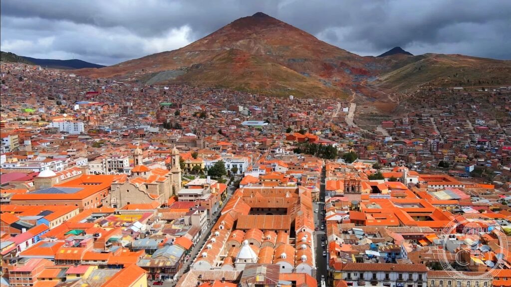
What you see
The historic centre of Potosí is a UNESCO zone of approximately 160 ha surrounding the Cerro Rico; the central plaza (Plaza 10 de Noviembre, the former Plaza Mayor) is flanked by the Cathedral and the Prefectural Palace; the main streets (Calle Bolívar, Calle Ayacucho) link the plaza to the surviving colonial churches and the Casa de la Moneda. The Casa de la Moneda (open Tuesday–Sunday, approximately 10 USD admission) takes 2–3 hours for a thorough visit; the ground floor machinery hall (with the original wooden rolling and cutting machinery, driven by water power through the mountain) and the collection of colonial silver coins and religious art are the highlights.
The altitude (3,967 m) affects all visitors — allow at least 24 hours of acclimatisation in Sucre (2,750 m, 3 hours from Potosí) or La Paz before vigorous activity; walking slowly, drinking coca tea (maté de coca, available everywhere), and avoiding alcohol for the first 24 hours reduces altitude sickness. The view of the Cerro Rico from the Casa de la Moneda forecourt — the perfectly conical red-brown mountain that dominates the entire city — is the defining image of Potosí, visible from every street that looks east.
Practical information
- Admission: historic centre streets are free; Casa de la Moneda approximately $10–15 USD with a compulsory guide; mine tours (Cerro Rico cooperative mines) approximately $15–20 USD for 3–4 hours; local guide services run from the main tourist agencies on Calle Matos and Calle Ayacucho; mine tours include safety helmets, boots, and a respirator; the mines are physically demanding and not recommended for those with claustrophobia, respiratory issues, or severe altitude sickness
- Getting there: the nearest major airport is Juana Azurduy de Padilla International Airport (SRE) in Sucre, approximately 165 km north of Potosí; BoA and Amaszonas fly from La Paz (1h) and Santa Cruz de la Sierra (1.5h) to Sucre; from Sucre to Potosí by bus (3 hours) or taxi (2.5 hours); Potosí Capitán Rogelio Rosales Airport (POI) has limited direct connections from Cochabamba and Santa Cruz; buses also connect Potosí to La Paz (10 hours overnight) and Uyuni (the salt flats, 3 hours south)
- Uyuni Circuit: Potosí is almost always combined with the Salar de Uyuni (the world’s largest salt flat, 10,582 km², 3 hours south of Potosí), one of the most visually spectacular landscapes in the world; 3-day/2-night Uyuni tours from Potosí visit the salt flat, the red-and-green lagunas of the Bolivian altiplano, the Eduardo Avaroa Andean Fauna National Reserve, and (optionally) cross the border to San Pedro de Atacama in Chile
Getting there
Nearest airport: Sucre (SRE, 165 km, 3h by bus or 2.5h by taxi). Limited direct flights to Potosí (POI). Bus connections to La Paz (10h) and Uyuni (3h). GPS: -19.5836, -65.7531.
Nearby
Sources
- Wikipedia, Potosí; Cerro Rico; Mita (Inca), accessed June 2026
- UNESCO, City of Potosí, WHS reference 420, inscribed 1987; on Danger List since 2014
- Peter Bakewell, Miners of the Red Mountain: Indian Labor in Potosí, 1545–1650, University of New Mexico Press, 1984
- Eduardo Galeano, Open Veins of Latin America, Monthly Review Press, 1973, Chapter 1
Find it on the map
See this place and what’s around it →📷 Diventa un fotografo di Cultural Heritage Online
Condividi le tue foto dei luoghi: restano pubblicate con la tua firma come autore. Più vengono viste, più ti fai conoscere — e presto un concorso premierà le foto più apprezzate.
Accedi o registrati gratis per aggiungere una foto