Cinque Terre e Portovenere — i Cinque Borghi sulla Costa Ligure (1997): Terrazze di Vite e Dimore Medievali su una Delle Coste più Ripide d’Europa (UNESCO 1997)
The Cinque Terre are five medieval villages — Riomaggiore, Manarola, Corniglia, Vernazza, Monterosso al Mare — built on a 15-kilometre stretch of the Ligurian coast between La Spezia and Levanto, on cliffs so steep (slopes up to 80 percent) that for 700 years the only way to cultivate them was to build stone-walled terraces by hand: 1,200 km of stone walls, more than the Great Wall of China, constructed over seven centuries to grow the Sciacchetrà wine grapes that define the terraced landscape of the Cinque Terre UNESCO World Heritage Site.
At a glance
The Cinque Terre (Five Lands) is a UNESCO World Heritage Site inscribed in 1997 (ref. 826) as “Portovenere, Cinque Terre, and the Islands (Palmaria, Tino and Tinetto).” The inscription covers the five villages (Riomaggiore, Manarola, Corniglia, Vernazza, Monterosso al Mare), the coastal territory between them (including the Parco Nazionale delle Cinque Terre, established 1999), and the town of Portovenere at the southern end of the Gulf of La Spezia. The outstanding universal value of the site lies in the unique cultural landscape created by the millennial interaction of human settlement and the coastal terrain: the terraced vineyards, the networks of caruggi (narrow medieval alleys), the painted house facades, and the five villages themselves, each built against the cliff and accessible traditionally only by boat or footpath.
Key facts
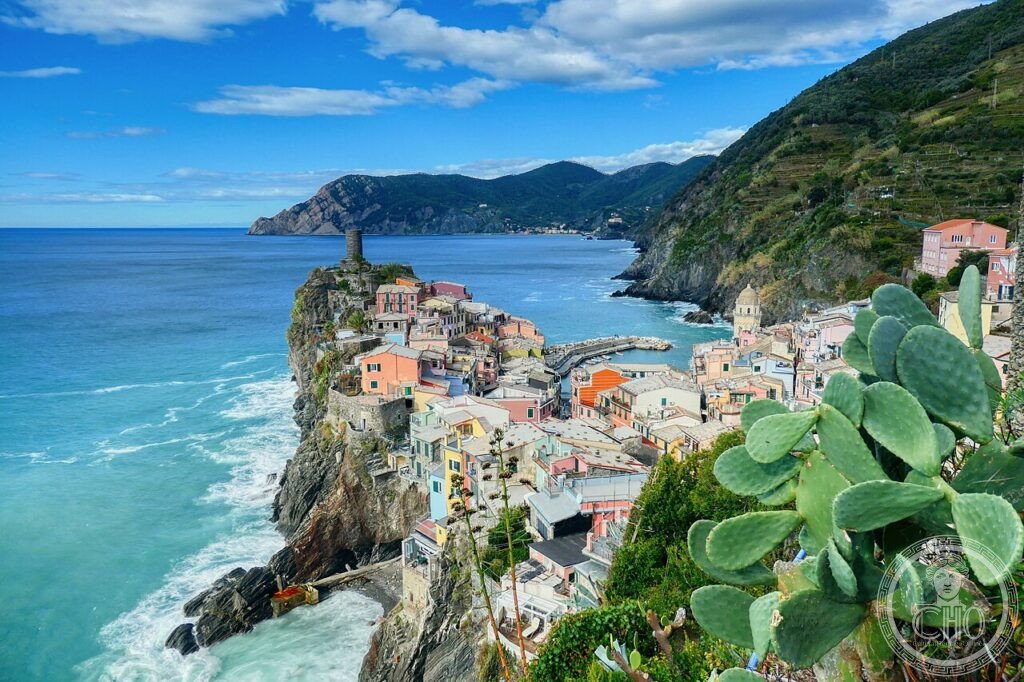
- The five villages: Riomaggiore (southernmost; the largest, approximately 1,700 inhabitants; the Via dell’Amore footpath begins here); Manarola (the most photographed, with the cluster of coloured houses reflected in the harbor in winter); Corniglia (the only village not on the sea — perched at 100m above the sea on a promontory, accessible by 382 steps from the train station); Vernazza (voted “the most beautiful village” in Italy multiple times; the harbor piazza with the Doria castle above); Monterosso al Mare (the largest beach; divided into the old town and the modern Fegina quarter)
- Stone terraces: Approximately 1,200 km of dry-stone retaining walls, constructed between the 12th and 19th centuries; the total wall surface area is approximately 6,700 hectares; the terraces have been in decline since the mid-20th century (the population of the five villages fell from approximately 10,000 in 1900 to approximately 4,000 today) and approximately 40% of the terraced area is now abandoned; the Parco Nazionale coordinates restoration work with local volunteers
- Sciacchetrà: The traditional sweet dessert wine of the Cinque Terre, produced from partially dried Bosco, Albarola, and Vermentino grapes; approximately 10-15 tonnes produced annually (one of the smallest-production DOC wines in Italy); only produced from terraced vineyards within the Cinque Terre boundaries; the name derives from the Ligurian dialect words for “press” (schiacciare) and “extract” (trarre)
- Portovenere: 8 km south of Riomaggiore (accessible by boat from all five villages); a medieval town on a narrow peninsula at the mouth of the Gulf of La Spezia; the Church of San Pietro (black-and-white marble, 1277) on the cliff above the sea is the most photographed building in the area; the Grotta Arpaia (Byron’s Cave) below the church is the site where Byron was said to have swum across the Gulf of La Spezia to visit Shelley at San Terenzo in 1822 (the story is likely apocryphal)
- UNESCO: 1997, ref. 826
- GPS: 44.1010, 9.7297 — Google Maps
History
The five villages of the Cinque Terre were settled between the 10th and 12th centuries, primarily as defensive settlements on natural promontories that could be accessed by sea but were difficult to attack by land. The Marquis of Massa-Carrara and later the Republic of Genoa controlled the coast; the villages were primarily fishing settlements with the terraced vineyards providing the secondary income. The construction of the terraced system — which defines the Cinque Terre landscape more than any single building — was a collective effort over 700 years: each generation of farmers added and repaired the stone walls, creating a landscape that is entirely artificial (no natural terracing exists on these cliffs) but appears as natural as the limestone cliffs below it.
The railway (the Genoa-La Spezia line, completed 1874) transformed the isolation of the five villages into accessibility — the villages, which had previously been connected to the outside world only by footpath and boat, were now 2 hours from Genoa — but at the cost of requiring a series of tunnels and embankments that altered the coastline at Monterosso and Riomaggiore. The railway connection enabled the slow decline of the terraced agriculture (young villagers migrated to Genoa and La Spezia for factory work after 1874) and the simultaneous beginning of tourism (Byron and Shelley had visited the Gulf of La Spezia in the 1820s, before the railway; the railway made the area accessible to middle-class travelers by 1880).
What you see
The Cinque Terre is experienced primarily on foot — the network of sentieri (footpaths) connecting the five villages along the coast and through the terraced vineyards is the primary experience of the UNESCO site. The most famous route is the Sentiero Azzurro (Blue Path, Sentiero n. 2), which follows the coast at low altitude between all five villages; the Via dell’Amore (the most photogenic section, between Riomaggiore and Manarola, carved into the cliff face above the sea) was closed for rockfall repairs since 2012 and partially reopened in 2023. The higher-altitude paths (Sentiero n. 1, the Alta Via delle Cinque Terre, at 400-600m altitude through the vineyards) offer the panoramic views of the coast that the low path cannot provide, but require 5-6 hours of walking.
The harbour piazza in Vernazza is the most beautiful single space in the Cinque Terre — a small rectangular piazza opening directly to the sea, with the coloured houses of the village on three sides and the Doria castle on the cliff above. In the early morning (before 8:00), before the day-tourist trains arrive from La Spezia (which disgorge approximately 5,000 visitors per day in summer), the piazza has the character of a genuine working village; by 10:00 it is very crowded.
Gallery
Practical information
- Getting around: The train (Trenitalia regional service on the Genova-La Spezia line) stops at all five villages and is the primary mode of transport; the Cinque Terre Card (from the Parco Nazionale; €7.50-18.50/day depending on mode and season) covers train travel between the five villages and access to the payable footpaths. Private cars cannot enter the village centres; limited parking above Manarola and Riomaggiore fills by 9:00 in summer.
- Crowds: The Cinque Terre are among the most overcrowded UNESCO sites in Italy (estimated 2.5 million visitors/year in a territory of approximately 4,000 permanent residents); July-August is extreme (all footpaths crowded by 9:00; trains packed; villages closed to additional visitors after 11:00 some days). The best months are October, November, March, and April.
- Accommodation: Very limited; most visitors come as day-trips from La Spezia, Genoa, or Florence. Staying overnight in Riomaggiore or Manarola gives access to the villages at sunrise and after the day-visitors leave (after 18:00).
Getting there
La Spezia, Liguria. By train: Trenitalia from Genova (80 km; 1h20); from Pisa (90 km; 1h10); from Florence (3h via Pisa or via La Spezia). All five villages are on the Genova-La Spezia regional line (Trenitalia R or RV service); travel times between villages: 3-5 min by train. The most common approach is to take the train to La Spezia Centrale (the terminus) and travel north. By ferry (in season): Consorzio Marittimo boats connect all 5 villages and Portovenere from La Spezia (April-October); the boat connection is the best way to see the villages from the sea.
Nearby
- Portovenere — 8 km south of Riomaggiore by boat; Church of San Pietro (1277, cliff-edge, black-and-white marble, one of the most photographed buildings on the Ligurian coast); the Aragonese castle (14th century); the cave of Byron; ferry access to Palmaria island (the largest island on the Ligurian coast; footpaths, the Black Marble quarry in use since Roman times)
- La Spezia — 15 km south; the Museo Nazionale della Marina Militare (Italian naval history, including the MAS torpedo boats of WWI) and the Museo d’Arte Moderna “Amedeo Lia” (one of the best collections of early Italian painting in the Ligurian region: Cimabue, Titian, Tintoretto); the Arsenale Militare (the main naval base of the Italian Navy since 1869; the harbour is one of the most protected in the Mediterranean)
- Lerici — 12 km south-east; the castle (13th century Pisan, later Genoese; the Museo del Castello di Lerici with archaeological finds from the Gulf of La Spezia); the Villa Marigola where Shelley drowned (1822, sailing from Lerici to Livorno in a storm); the Golfo dei Poeti (the Gulf of Poets) name derives from Byron and Shelley’s residence in 1821-22
Sources
- UNESCO: whc.unesco.org/en/list/826
- Wikipedia EN: Cinque Terre
- Croce, Franco: Le Cinque Terre, Sagep, Genova, 2003
- Parco Nazionale delle Cinque Terre: parconazionale5terre.it
Find it on the map
See this place and what’s around it →📷 Diventa un fotografo di Cultural Heritage Online
Condividi le tue foto dei luoghi: restano pubblicate con la tua firma come autore. Più vengono viste, più ti fai conoscere — e presto un concorso premierà le foto più apprezzate.
Accedi o registrati gratis per aggiungere una foto