Parco Nazionale delle Caverne del Peruaçu (sito misto): arte rupestre preistorica e grotte calcaree nel cerrado brasiliano
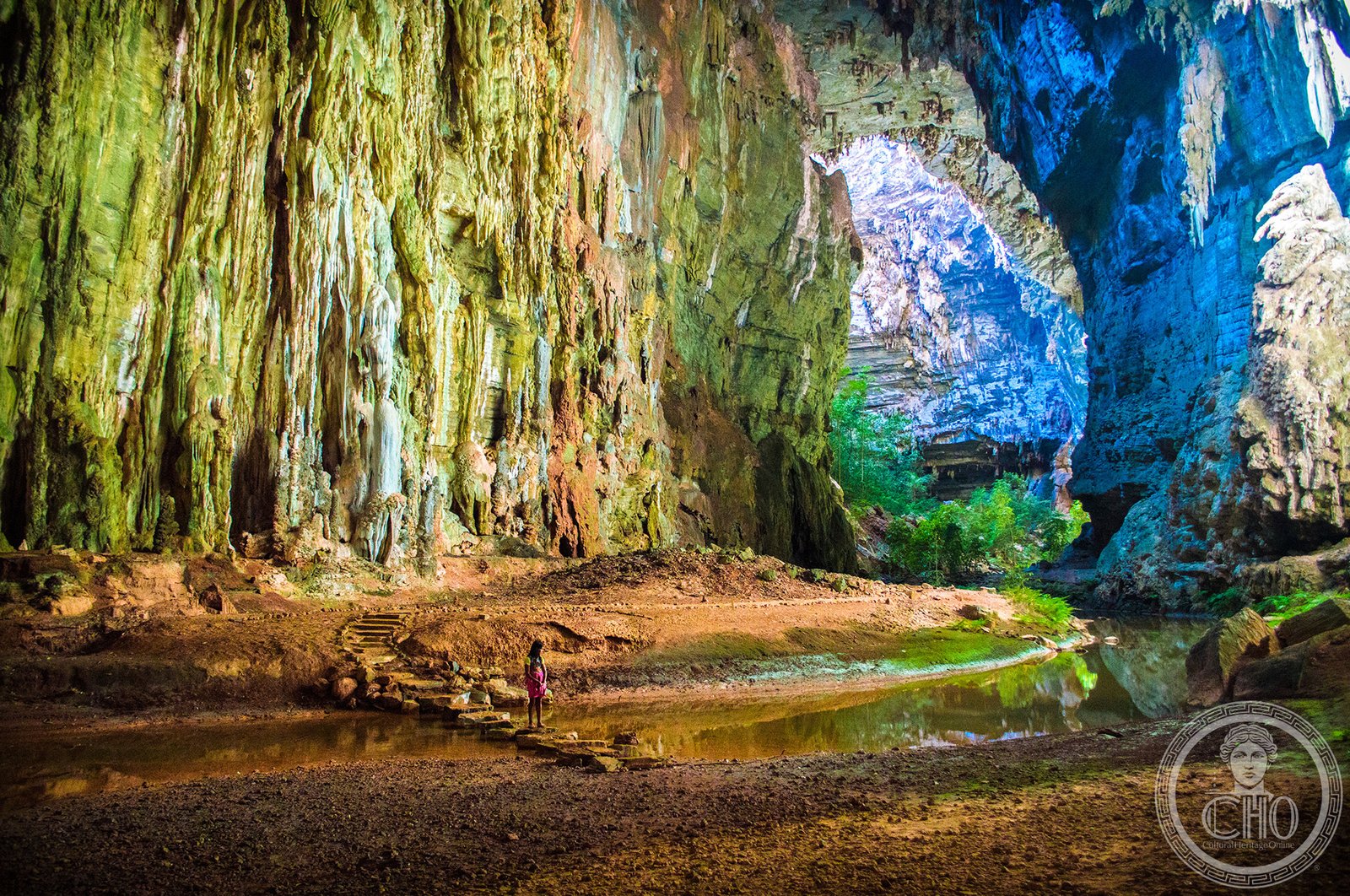
Nel nord del Minas Gerais, dove il Rio São Francisco traccia il confine tra il cerrado e il sertão semiarido, il canyon calcareo del Rio Peruaçu ospita una delle più importanti concentrazioni di arte rupestre preistorica del Sud America. Oltre 180 siti con pitture e incisioni rupestri databili da 12.000 anni fa, custoditi in grotte di proporzioni grandiose — la Grotta Janelão, la grotta più alta del Brasile, è abbastanza grande da contenere il Cristo Redentore di Rio. Un sito UNESCO dal 2001 dove la natura (cerrado intatto, fauna endemica) si unisce a millenni di storia umana.
At a glance
Cavernas do Peruaçu National Park (14,894 hectares) is a mixed World Heritage Site inscribed in 2001 (ref. 1035) in north Minas Gerais, Brazil. The park protects a limestone canyon carved by the Rio Peruaçu, a tributary of the São Francisco, containing over 180 known prehistoric rock-art sites, outstanding speleological features (giant stalactite-decorated caves, subterranean rivers) and significant cerrado/caatinga biodiversity. The cave Janelão is the largest natural rock-arch chamber in Brazil at 130 m high and 250 m long. The neighbouring Xakriabá indigenous people maintain a living connection to the landscape.
Key facts
- UNESCO: World Heritage since 2001 (Cavernas do Peruaçu National Park, ref. 1035)
- Rock art: over 180 prehistoric sites with paintings and engravings; oldest dated to c. 12,000 BP
- Janelão cave: the largest natural cave chamber in Brazil (130 m high, 250 m long)
- Biodiversity: cerrado ecosystem with jaguars, maned wolves, giant anteaters, giant armadillos, pumas
- Indigenous people: the Xakriabá people live in the buffer zone; maintain traditional knowledge of the landscape
- Speleology: 140 km of surveyed cave passages; 11 km accessible to visitors
History
The caves of the Peruaçu valley were used by Palaeolithic hunter-gatherers from at least 12,000 years ago. The rock paintings — in red, yellow, black and white ochre — depict anthropomorphic figures, hunting scenes, animals (deer, armadillos, fish), geometric patterns and handprints. The most dramatic panels are in the Gruta do Janelão and Gruta do Palheiro, where multiple layers of paintings accumulated over thousands of years.
The Xakriabá people, who now live in an indigenous territory adjacent to the park, are descended from groups that inhabited the region after the prehistoric painters. In the 17th century, Jesuit missionaries documented the existence of indigenous peoples in the Peruaçu valley; conflicts with colonial settlers pushed the Xakriabá toward the São Francisco River. Today they number approximately 10,000 and maintain traditional ceremonies linked to the cave landscape. The national park was created in 1999, and UNESCO inscription followed in 2001.
What you see
The park is best explored on guided trails: the Canyon Trail takes visitors into the limestone gorge, with painted shelters visible on the walls. The Janelão circuit enters the immense cave chamber — the scale is staggering, with stalactites and stalagmites in the dim light flooding through the natural arch at the far end. The Lapa do Boquete shelter has the most complex painted panels, with hundreds of superimposed figures.
The surrounding cerrado is rich in wildlife: guided dawn walks from the park research station often yield giant anteaters and armadillos; maned wolves are heard at dusk. Bats numbering in the thousands emerge from the cave entrances at sunset.
Practical information
- Access: the park is 7 km from Januária (the nearest town, with accommodation); guides obligatory for all routes
- Best time: May–September (dry season; water levels low in caves, easier access)
- Booking: tours must be booked in advance through ICMBIO (the Brazilian national parks authority) or local guides
- Nearest city: Montes Claros (200 km south, with airport) or Belo Horizonte (600 km south)
Getting there
By road from Belo Horizonte: take the BR-135 north to Januária (580 km, 7 hrs); the park entrance is 7 km north of Januária. Bus service from Belo Horizonte to Januária runs daily (10 hrs). GPS: 15.12° S, 44.32° W.
Nearby
- Januária — the riverside town on the São Francisco River; São Francisco boat trips available
- Parque Nacional Grande Sertão Veredas — the cerrado wetlands national park, 200 km south-east
- Belo Horizonte — the capital of Minas Gerais, with world-class museums and cuisine, 580 km south
Sources
- UNESCO World Heritage Centre — “Cavernas do Peruaçu National Park” (ref. 1035)
- ICMBIO — Parque Nacional Cavernas do Peruaçu
- Encyclopaedia Britannica — Peruaçu River
Find it on the map
See this place and what’s around it →📷 Diventa un fotografo di Cultural Heritage Online
Condividi le tue foto dei luoghi: restano pubblicate con la tua firma come autore. Più vengono viste, più ti fai conoscere — e presto un concorso premierà le foto più apprezzate.
Accedi o registrati gratis per aggiungere una foto