
The Underground City
Beneath the dry hills of the Judean Lowlands, a world exists that most people pass above without suspecting. At Beit Guvrin, approximately 800 man-made chambers lie hidden under the surface — bell caves, columbaria, cisterns, oil presses, bathhouses, and burial chambers carved from soft chalk bedrock over two millennia. You descend through a narrow opening and find yourself in a perfect hemisphere of white stone, 25 metres across, light pouring through a circular hole at the top like a shaft of theatrical illumination. The acoustic effect — voices folding on themselves, a single handclap blooming into a chord — is unlike anything above ground.
Beit Guvrin-Maresha National Park was designated a UNESCO World Heritage Site in 2014, recognised as an exceptional example of a subterranean landscape created by human quarrying activity over hundreds of years. The site sits approximately 50 kilometres southwest of Jerusalem, in a region contested, settled, and resettled by Phoenicians, Greeks, Idumeans, Romans, Byzantines, Crusaders, and Arabs over twenty-five centuries.
The Bell Caves — Form, Function, and Wonder
The approximately 800 bell caves at Beit Guvrin were created through a distinctive quarrying process: a vertical shaft was sunk through a thin layer of hard limestone, then the soft chalk beneath was carved outward and downward, widening the cavity until the ceiling could not support further expansion. The result is a chamber shaped like an inverted bell — a narrow circular opening at the top, a dramatically expanding dome below, tapering again toward the floor. Individual caves measure up to 25 metres in diameter and 12 metres in height.
The caves were quarried primarily during the late Roman and early Byzantine periods (approximately 3rd to 7th centuries AD) and continued into the early Arab period (7th to 10th centuries). The chalk extracted was used as a building material throughout the region. Some chambers were connected to form networks; others contain carved crosses, Arabic inscriptions, and niches suggesting secondary uses as storage or temporary shelter.
Ancient Maresha — The Hellenistic City Below
Beneath the tel adjacent to the bell caves lie the remains of Maresha, a Hellenistic city occupied from roughly the 4th century BC until its destruction by the Hasmonean king John Hyrcanus in 112 BC. Maresha was as much underground as above it. The soft chalk that made the bell caves possible also encouraged its inhabitants to carve an entire domestic infrastructure beneath the surface: cisterns, oil presses, dyeing installations, stables, storage chambers, and columbaria — multi-room chambers with hundreds of niches cut into the walls for nesting pigeons and doves.
The columbaria at Maresha are extraordinary structures. A single room might contain 2,000 individual niches, each carved to exact dimensions. The birds provided guano for fertilizer, meat, and possibly sacrificial animals; the sheer scale of the installations suggests Maresha was a significant centre of this industry. Archaeologists have counted more than 85 columbaria in the Maresha complex.
The Sidonian Burial Caves
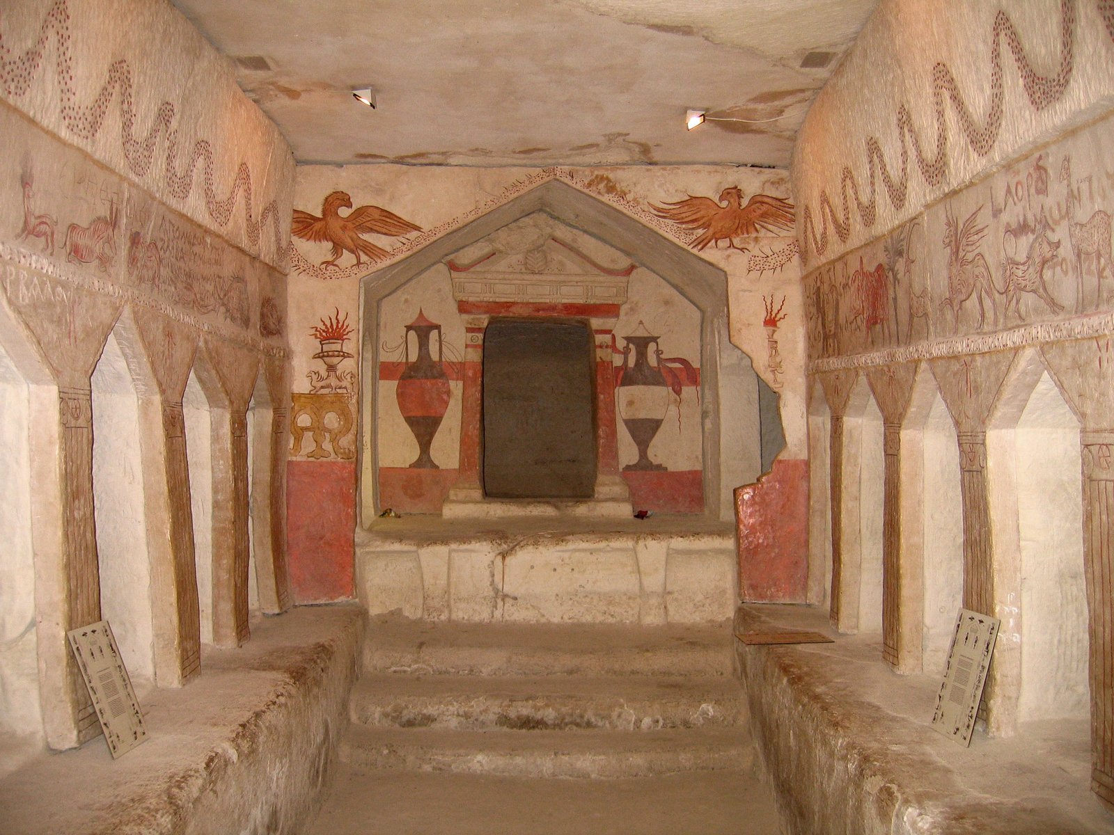
Among the most significant discoveries at Maresha are the Sidonian burial caves: a series of rock-cut tombs containing some of the finest Hellenistic funerary art outside Egypt. The caves date to approximately the 3rd to 2nd century BC and belonged to the community of Sidonians — Phoenician merchants from what is now Lebanon — who had settled in Maresha during the Hellenistic period. The painted walls of the main burial cave depict life-size animals: an elephant, a rhinoceros, a crocodile, a hippopotamus, hunting dogs, and wild animals in combat, rendered with considerable naturalistic skill.
A Greek inscription identifies the tomb as belonging to Apollophanes, head of the Sidonian community at Maresha, and dates the paintings to approximately 196 BC. The inscriptions in the cave — in Greek, Aramaic, and Phoenician — speak to the multilingual reality of Hellenistic Judea. The caves are accessible on guided tours within the national park.
The Roman City of Eleutheropolis
After Maresha was destroyed in 112 BC, the area was resettled during the Hasmonean and Herodian periods. Following the First Jewish-Roman War (66-73 AD), the Romans established the city of Eleutheropolis (“city of free people”) — a major administrative centre that flourished for several centuries. The bell caves were created by its inhabitants as they quarried building material for the expanding city above. Excavations have revealed a theatre, public baths, colonnaded streets, and a large administrative complex from the Roman and Byzantine phases.
The Arabic name “Beit Guvrin,” meaning “house of the warriors” in Aramaic, preserves the memory of this civic identity through medieval Islamic geography. A Crusader castle — Gibelin — was built on the same site in 1136 AD.
Public Archaeology and the Visitor Experience
Beit Guvrin is notable for an unusual feature: visitors can participate in supervised archaeological digs in designated excavation areas. This programme has made it one of the most popular archaeological sites in Israel for school groups and family visits. The experience of entering the bell caves is genuinely immersive — descending into darkness and re-emerging into vast underground chambers with extraordinary acoustics.
Among the significant finds over decades of excavation: a mosaic floor from a Byzantine-era church, thousands of coins spanning five centuries, well-preserved organic materials from sealed chalk chambers, and graffiti scratched into cave walls by quarry workers and pilgrims that document daily life in ways formal archaeology rarely captures.
How to Get There
Beit Guvrin-Maresha National Park is managed by the Israel Nature and Parks Authority and is open year-round. It is approximately 50 kilometres southwest of Jerusalem and 20 kilometres from Kiryat Gat, accessible by car via Highway 35. Public transport connections are limited; most visitors arrive by private vehicle or organised tour from Jerusalem, Tel Aviv, or the Dead Sea region. Allow 2 to 3 hours for a thorough visit; guided tours for the Sidonian burial caves are included in the park entrance fee.
Essential Facts
- UNESCO WHS
- Inscribed 2014 — Caves of Maresha and Bet-Guvrin in the Judean Lowlands
- Period
- 4th century BC to 10th century AD (Hellenistic through early Arab)
- Bell caves
- Approximately 800 man-made chambers, up to 25m diameter and 12m height
- Location
- Judean Lowlands, Israel, approximately 50km southwest of Jerusalem
- GPS
- 31.6017 N, 34.8946 E
- Managed by
- Israel Nature and Parks Authority
- Access
- Year-round; guided tours required for Sidonian burial caves
Find it on the map
See this place and what’s around it →📷 Become a Cultural Heritage Online photographer
Share your photos of places: they stay published under your name as the author. The more they're seen, the more you get noticed — and soon a contest will reward the most appreciated photos.
Log in or sign up free to add a photo