

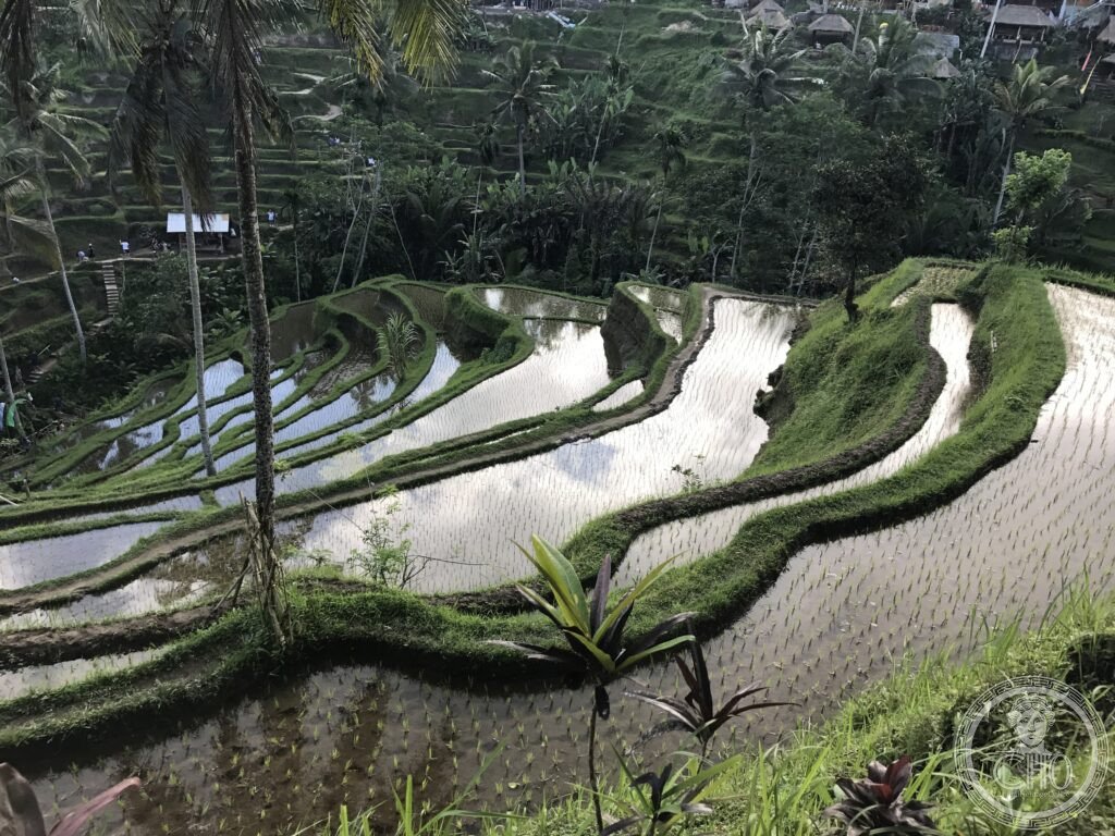
Around Ubud, rice terraces cascade down volcanic slopes fed by a water-sharing system that Balinese farmers have run as a cooperative for over a thousand years. Regulated from mountain water temples and guided by the philosophy of Tri Hita Karana, the subak landscape links irrigation, Hindu ritual and village life into a single working whole.
At a glance
Balinese culture rests on the philosophy of Tri Hita Karana, the three causes of wellbeing: harmony with God, harmony with fellow humans, and harmony with nature. The subak irrigation system is considered a direct expression of this idea in practical form. Balinese Hinduism itself is distinct from the Hinduism practised in India, blending it with animism, ancestor worship and elements drawn from Buddhism. Every village on the island keeps three temples: Pura Puseh for village origins, Pura Desa for communal life, and Pura Dalem connected with the dead.
Key facts
- UNESCO listing: the Cultural Landscape of Bali Province was inscribed in 2012 around five components: Pura Ulun Danu Batur and the Lake Batur crater lake, the Jatiluwih rice terraces, Pura Taman Ayun at Mengwi, Pura Luhur Batukaru, and the associated subak landscape of Catur Angga Batukaru.
- Pura Besakih: known as the Mother Temple, this complex on the slopes of Gunung Agung has stood for over a thousand years and contains 86 individual temples.
- Gunung Agung: an active volcano rising to 3,031 metres, last erupting between 2017 and 2019; its 1963 eruption was catastrophic, killing an estimated 1,500 people and destroying several villages.
- Kecak dance: performed by a chorus of fifty to two hundred men chanting rhythmically with no instruments, dramatising the Ramayana battle between Hanuman’s monkey army and Ravana; the best-known setting is the clifftop temple of Uluwatu at sunset.
History
The subak system appears in Balinese inscriptions dating to the 9th century and evolved gradually over the following centuries. In 1343 the Majapahit Hindu-Buddhist empire of Java conquered Bali and established the Balinese Hindu tradition that survives today; when Majapahit collapsed in the 15th century under Islamic pressure, Bali retained this heritage largely intact.
The Dutch did not bring Bali under colonial control until 1906–1908, far later than the rest of the Dutch East Indies. Balinese royal families of Denpasar and Klungkung met the Dutch advance with mass ritual suicide, the puputan, an act that reportedly shook the Dutch troops who witnessed it. The subak landscape’s cooperative water management and its ties to temple worship were recognised by UNESCO in 2012.
What you see
At Jatiluwih, one of the five listed components, rice terraces sweep in broad curves up the slopes of Gunung Batukaru. Traditional red rice varieties are grown here, and the unhusked grain gives the fields a terracotta colour at harvest time. Near Kintamani, the crater lake of Batur sits below the still-active Gunung Batur volcano, a spot known for its sunrise views and for dawn hikes to the summit.
Practical information
- Route: a well-worn circuit links Tirta Empul spring temple, the Tegallalang rice terraces, Pura Ulun Danu Batur at the crater lake, the Kintamani viewpoint, the Jatiluwih terraces, Tanah Lot sea temple and the Uluwatu Kecak performance.
- Tirta Empul: a 9th-century spring temple where pilgrims bathe in the sacred pools; visitors are generally welcome to join wearing a sarong.
- Booking: the Uluwatu Kecak performance and entry arrangements for sites such as Jatiluwih are best checked through official local or temple channels before visiting.
Getting there
Bali is reached through Ngurah Rai International Airport (DPS) at Denpasar, which has direct connections from major Asian cities and Australia and further links from Europe. Ubud lies to the north of Denpasar; the heritage circuit from there runs through Tirta Empul, Tegallalang, Kintamani, Jatiluwih, Tanah Lot and Uluwatu.
Nearby
- Lombok and the Gili Islands — reached by fast boat; Gili Trawangan, Air and Meno allow no motorised vehicles, relying instead on horse carts and bicycles, with clear water where sea turtles can be seen while snorkelling.
- Gunung Rinjani — an active volcano on Lombok and Indonesia’s second-highest, with a crater lake and a multi-day trek to its summit.
- Ubud Palace and Sacred Monkey Forest — in the centre of Ubud; the Puri Saren Agung royal palace stages traditional Legong, Barong and Wayang performances in its courtyard, while the Sacred Monkey Forest Sanctuary at Padangtegal shelters long-tailed macaques among three ancient temples.
- Borobudur and Prambanan, Java — reached by a short flight to Yogyakarta; Borobudur, the world’s largest Buddhist monument, dates from the 9th century and carries thousands of bas-relief panels and Buddha statues, while nearby Prambanan is a 9th-century Hindu temple complex of some 240 structures.
Sources
- Wikipedia, Cultural Landscape of Bali Province
- Wikipedia, Subak (Bali)
- Wikipedia, Kecak
- Wikipedia, Pura Besakih
- UNESCO, Cultural Landscape of Bali Province: the Subak System as a Manifestation of the Tri Hita Karana Philosophy (WHS reference 1194rev)
Find it on the map
See this place and what’s around it →📷 Become a Cultural Heritage Online photographer
Share your photos of places: they stay published under your name as the author. The more they're seen, the more you get noticed — and soon a contest will reward the most appreciated photos.
Log in or sign up free to add a photo