Ayutthaya
For 417 years (1351–1767) the capital of the Kingdom of Ayutthaya — the dominant political power of mainland Southeast Asia, which at its peak governed a trading empire that Portuguese, Dutch, French, and Chinese merchants called one of the richest cities on earth — before the Burmese army of King Hsinbyushin sacked it, burned it, and led 30,000 captives north to Ava, leaving the brick prang and collapsed Buddha statues that are the most evocative ruins in Southeast Asia.
At a glance
Ayutthaya (Thai: อยุธยา) was the capital of the Kingdom of Ayutthaya from 1351 to 1767, located on an island formed by the confluence of the Chao Phraya, Pa Sak, and Lopburi rivers, 80 km north of modern Bangkok. At the peak of its power in the 16th–17th centuries, the city had a population of approximately 1 million people — larger than Paris, Amsterdam, or London at the same time — and was visited by the embassies of dozens of foreign nations. The kingdom’s control of the sea trade routes between China and India, and its production of rice, forest products, and Chinese goods for re-export, made it immensely wealthy. The city was systematically sacked and burned by the Burmese in 1767 in the third and final Burmese-Siamese War; it was never rebuilt. The Ayutthaya Historical Park covers the ruins of the city centre and is a UNESCO World Heritage Site inscribed in 1991.
Key facts
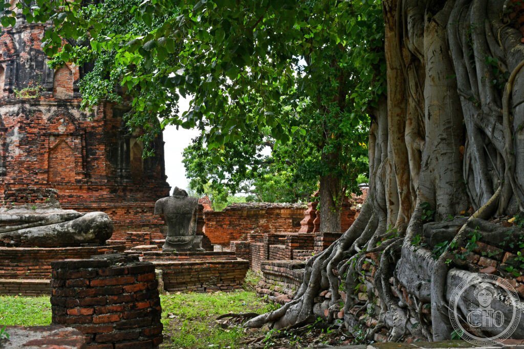
- Wat Mahathat: the royal temple at the centre of the old city; the ruined prang (Khmer-style tower) and its surrounding galleries have been partially excavated; famous for a stone Buddha head grown into the roots of a bodhi tree (the image dates from when the head fell from a statue and the tree grew around it over centuries); the most visited site in the park
- Wat Phra Si Sanphet: the most important royal temple; the three chedis (stupas) in a row contain the ashes of three Ayutthaya kings; modelled on Wat Phra Kaeo in Bangkok (which was itself modelled on this temple); the site of a giant gilded standing Buddha (Phra Si Sanphet) melted down for its gold by the Burmese
- Elephant kraal (Phan Chang): Ayutthaya maintained one of the largest war elephant forces in Asia; the royal elephant kraal (pen) — the largest surviving structure of its kind — was used to capture wild elephants; the kingdom’s battles were often decided by elephant charges
- Foreign quarter: Ayutthaya had permanent settlements of Portuguese, Dutch, French, Japanese, Chinese, Malay, and Indian merchants; the Portuguese were the first Europeans (1511); the Japanese quarter under Yamada Nagamasa (early 17th century) had over 1,000 residents; the French ambassadors of Louis XIV visited in 1685–1686, and the Thai king Narai sent his own embassy to the court of Versailles
- The sack of 1767: the city burned for months; the heat melted the lead in the roof coverings of the temples and fused it with the gold of the Buddha images; many of the headless Buddha statues in the park lost their heads to Burmese soldiers who cut them off to recover the gold that had been inserted inside during casting
- Heritage: UNESCO World Heritage Site, Historic City of Ayutthaya, inscribed 1991
- GPS: 14.3569° N, 100.5675° E
History
The Kingdom of Ayutthaya was founded by Ramathibodi I in 1351, unifying the former Khmer-influenced polity of Lopburi with the Tai kingdoms of the central plain. For the first century, the kingdom expanded through a combination of diplomacy and military force; the conquest of the Khmer capital Angkor in 1431 brought the Khmer administrative and court traditions into the Ayutthayan system, including the devaraja (divine king) ideology that would characterise Ayutthayan kingship. The kingdom’s geographic position — on the central plain of mainland Southeast Asia, with river access to both the Gulf of Thailand and the interior — made it the natural entrepôt for the trade between China (the primary destination for tropical products), India (cloth and horses), and the island world of insular Southeast Asia.
The 16th and 17th centuries were the kingdom’s golden age: Portuguese merchant communities arrived after 1511; the kingdom maintained a professional standing army with Portuguese advisors and firearms; Dutch and English East India companies established factories in the city from the 1600s; the court maintained diplomatic correspondence with Japan, China, Persia, and France simultaneously. Contemporary European accounts describe a city of magnificent temples gilded with gold, a royal palace complex of extraordinary size, and river traffic so dense that the Chao Phraya was “covered with boats like a roof.”
The third Burmese-Siamese War (1765–1767) ended the kingdom definitively. The Burmese forces besieged the city for 14 months; when it fell in April 1767, they enslaved the population (an estimated 30,000 captives were marched to Burma), melted the temple gold, and burned the structures. The site was never rebuilt; the Thai court moved to Thonburi, then Bangkok, and Ayutthaya became an uninhabited ruin until the 20th century.
What you see
The historical park covers approximately 3 km² of the old city island; a bicycle (rented at the park entrance for THB 50–100 per day) is the ideal way to visit. The brick prang and chedi of the major temples rise from the flat plain without any modern structures obscuring the horizon; the scale of the ruined foundations gives a sense of the original city’s density. The iconic image of Ayutthaya — the Buddha head growing from the bodhi tree roots at Wat Mahathat — requires a short walk into the temple complex; photography is permitted but visitors are asked to kneel at the level of the image as a mark of respect.
Wat Phra Si Sanphet, with its three restored chedis, is the most formally impressive ruin; Wat Chaiwatthanaram (on the south-west corner of the island, reached by boat or bicycle) has the most complete surviving architecture, a cross-shaped central prang surrounded by four corner prangs in the Angkor-influenced style. The Chang Puak Elephant Kraal north of the city island can be combined with a visit to the Summer Palace at Bang Pa-In (20 km south), which has Victorian-era Thai royal buildings on a lake island.
Practical information
- Admission: THB 50 per temple; a combined ticket (THB 220) covers the five main Aruphacha Fine Arts Department sites; some temples are free
- Getting there: from Bangkok Hua Lamphong station, train to Ayutthaya (1.5 hours, THB 15–50); from Mo Chit bus terminal, bus (1.5 hours, THB 80); from Don Mueang Airport, shuttle to Rangsit then train; the city island is 2 km² and navigable by bicycle
- When to visit: the Loi Krathong festival in November illuminates the ruins with candles and lanterns; the light show at Wat Chaiwatthanaram on Friday and Saturday evenings
- Dress code: knees and shoulders must be covered at all temple sites; sarongs available for loan at major temples
Getting there
Ayutthaya is 80 km north of Bangkok; direct trains from Hua Lamphong station (1.5 hours, THB 15–50) run every 30–60 minutes. Don Mueang Airport (DMK) is the nearer Bangkok airport (40 km south). GPS: 14.3569, 100.5675.
Nearby
- Sukhothai Historical Park — the earlier Thai capital (c. 1238–1438); the first Thai kingdom before Ayutthaya; the ruined temples are set in a formal park of lakes and lotus ponds; considered by Thai nationalism to be the birthplace of the nation; UNESCO WHS; 5 hours north of Ayutthaya
- Bang Pa-In Royal Palace — the former summer palace of the Chakri kings, 20 km south of Ayutthaya on the Chao Phraya; eclectic architecture mixing Thai, Chinese, and European neo-Gothic pavilions on islands in an artificial lake; accessible by boat or train from Ayutthaya
- Wat Pho and the Grand Palace (Bangkok) — the Chakri dynasty built Bangkok’s temples directly in the tradition of Ayutthaya; Wat Pho (the Temple of the Reclining Buddha) and the Emerald Buddha at Wat Phra Kaeo are consciously derived from Ayutthayan prototypes; 80 km south
Sources
- Wikipedia, Ayutthaya (city), accessed June 2026
- UNESCO, Historic City of Ayutthaya, WHS reference 576, inscribed 1991
- David K. Wyatt, Thailand: A Short History, 2nd ed., Yale University Press, 2003
- Dhiravat na Pombejra, Siamese Court Life in the Seventeenth Century as Depicted in European Sources, Chulalongkorn University Press, 2001
Find it on the map
See this place and what’s around it →📷 Diventa un fotografo di Cultural Heritage Online
Condividi le tue foto dei luoghi: restano pubblicate con la tua firma come autore. Più vengono viste, più ti fai conoscere — e presto un concorso premierà le foto più apprezzate.
Accedi o registrati gratis per aggiungere una foto