Archaeological Sites of Bat, Al-Khutm and Al-Ayn
The most complete Bronze Age landscape in Arabia — stone towers, beehive tombs and a copper-trading civilisation at the crossroads of Mesopotamia and the Indus Valley, UNESCO-listed since 1988.
At a glance
On a gravel plain in the Dhahirah region of interior Oman, within sight of the Hajar Mountains, the ensemble of Bat, Al-Khutm and Al-Ayn preserves the most complete surviving landscape of the Umm al-Nar culture (c. 2600–2000 BC) — the earliest urbanised society known from the Arabian Peninsula. The site was inscribed on UNESCO’s World Heritage List in 1988. It combines domestic architecture (round mudbrick and stone towers at Bat, among the oldest standing structures on the peninsula) with one of the most visually dramatic mortuary landscapes of the Bronze Age: at Al-Ayn, 21 beehive tombs in a line against a mountain backdrop, each assembled from fitted limestone blocks without mortar, standing up to 5 metres high.
Key facts
- Location: Dhahirah region, interior Oman, near town of Ibri (40 km away)
- UNESCO: World Heritage Site since 1988 (same year as the Taj Mahal)
- Culture: Umm al-Nar (c. 2600–2000 BC), first urbanised society of the Arabian Peninsula
- Towers of Bat: round stone towers c. 3000 BC — among the oldest standing structures on the Arabian Peninsula
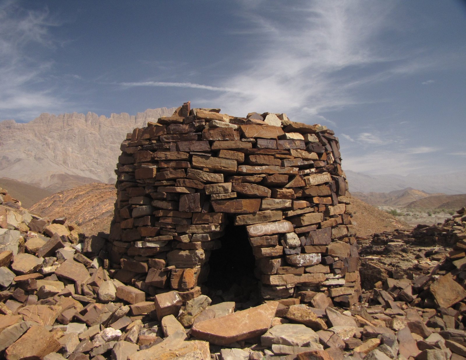
- Tombs at Al-Ayn: 21 beehive tombs in a row, up to 5 m high and 9 m diameter, corbelled construction, no mortar
- Trade connections: Mesopotamia (Ur, Nippur) and the Indus Valley (Mohenjo-daro); Omani copper and dates exported in exchange for lapis lazuli and carnelian
- Visitor centre: government-operated facility at Al-Ayn
History
Around 3000 BC, communities on the Omani plateau began constructing permanent stone towers on the gravel plains of the Dhahirah region. These towers at Bat were residential, defensive and functional simultaneously — mudbrick and stone cylinders of two or three storeys, serving as dwellings, grain stores, and community fortifications in a landscape where water was scarce and copper ore was abundant in the nearby Hajar Mountains. The Umm al-Nar culture that built them was not isolated: their copper smelting technology made them essential participants in the long-distance trade networks connecting Mesopotamia, the Gulf and the Indus Valley in the 3rd millennium BC. Archaeologists have found Omani copper at Ur and Nippur; at Bat and Al-Ayn they have found lapis lazuli from Afghanistan, carnelian from Gujarat, and pottery from Mesopotamia and the Indus.
The mortuary landscape is as impressive as the settlement. The beehive tombs scattered across the plain around Bat were built and used by communities over centuries, with multiple burials added to each chamber as generations passed. They were constructed using a corbelling technique — each successive ring of limestone blocks slightly overhanging the one below, converging toward a capstone at the apex — without any binding mortar. The largest tombs at Al-Khutm reach 9 metres in diameter at the base. At Al-Ayn, twenty-one tombs arranged in a loose line against the mountain form the most visually coherent Bronze Age funerary monument in Arabia: they function almost as a skyline marker, visible from the plain for kilometres.
By approximately 2000 BC, the Umm al-Nar culture had been absorbed into or replaced by later cultures. The towers of Bat gradually fell into disuse and decay; the tombs were not reused by later populations and remained essentially untouched until systematic archaeological surveys began in the 1970s. The absence of later occupation is precisely what makes the ensemble so archaeologically valuable: the Bronze Age landscape is readable with minimal interference.
What you see
At Bat village itself, the ruins of circular and sub-circular towers rise from the gravel plain, their mudbrick and rough stone walls eroded to stumps in places but complete to first-floor height in others. The layout of the settlement is legible: towers clustered within a roughly defined communal territory, with evidence of associated outdoor processing and storage areas. This is urban organisation, not nomadic camping — a significant statement for the early Bronze Age Arabian Peninsula.
At Al-Ayn, the beehive tombs are the dominant visual experience. Approaching from the visitor centre, the row of twenty-one domed structures stretches across the foreground with the dramatic ridge of the Hajar Mountains rising immediately behind. Each tomb is a self-contained corbelled dome of fitted limestone, its entrance sealed with a stone slab. Interior chambers, when excavated, contained disarticulated human bones from multiple individuals — community burial rather than individual interment — along with ceramic vessels, copper objects and personal ornaments. The craftsmanship of the fitted stone is remarkable: dry-stone construction achieved a structural stability that has allowed the tombs to stand for five millennia.
Practical information
The visitor centre at Al-Ayn is the recommended starting point. It provides orientation to all three sub-sites and is the only facility with shade and water on site. The tombs at Al-Ayn are accessible on foot from the centre; the Bat settlement is 2–3 km away by road. The site is open during daylight hours with a modest entry fee. Given the exposed desert location and summer temperatures exceeding 45 degrees C, visiting between October and March is strongly advised. Bring substantial water supplies regardless of season.
Getting there
From Muscat (280 km west): take the Adam–Nizwa highway to Ibri, then follow signs northwest to Bat and Al-Ayn (approximately 40 km from Ibri). A hired car or self-drive rental from Muscat is the most practical option; no public transport serves the site. The drive from Muscat via the interior takes approximately 3–3.5 hours. From Buraimi (UAE border crossing, 120 km north), the site is about 1.5 hours south. GPS: 23.2741 N, 56.7358 E.
Nearby
- Ibri (40 km east) — nearest town with accommodation, fuel and supplies; small local museum
- Falaj Daris Park, Nizwa (120 km southeast) — UNESCO-listed ancient aflaj irrigation system
- Bahla Fort (110 km southeast) — UNESCO World Heritage mudbrick fort, largest in Oman
- Hajar Mountains — dramatic geological landscape visible from the site; source of the copper ore that funded Umm al-Nar trade
Sources
- UNESCO World Heritage Centre, Archaeological Sites of Bat, Al-Khutm and Al-Ayn, whc.unesco.org/en/list/224
- Frifelt, K., The Island of Umm an-Nar, vol. 1: Third Millennium Graves, Jutland Archaeological Society, 1991
- Cleuziou, S. and Tosi, M., In the Shadow of the Ancestors, Ministry of Heritage and Culture, Sultanate of Oman, 2007
- Potts, D.T., The Arabian Gulf in Antiquity, 2 vols., Oxford University Press, 1990
- Orchard, J. and Stanger, G., Al-Magal: The Early Bronze Age site at Bat, Arabian Archaeology and Epigraphy 5 (1994)
Find it on the map
See this place and what’s around it →📷 Diventa un fotografo di Cultural Heritage Online
Condividi le tue foto dei luoghi: restano pubblicate con la tua firma come autore. Più vengono viste, più ti fai conoscere — e presto un concorso premierà le foto più apprezzate.
Accedi o registrati gratis per aggiungere una foto