Anticosti (sito naturale): la più grande isola-museo dei fossili del Siluriano e dell’Ordoviciano
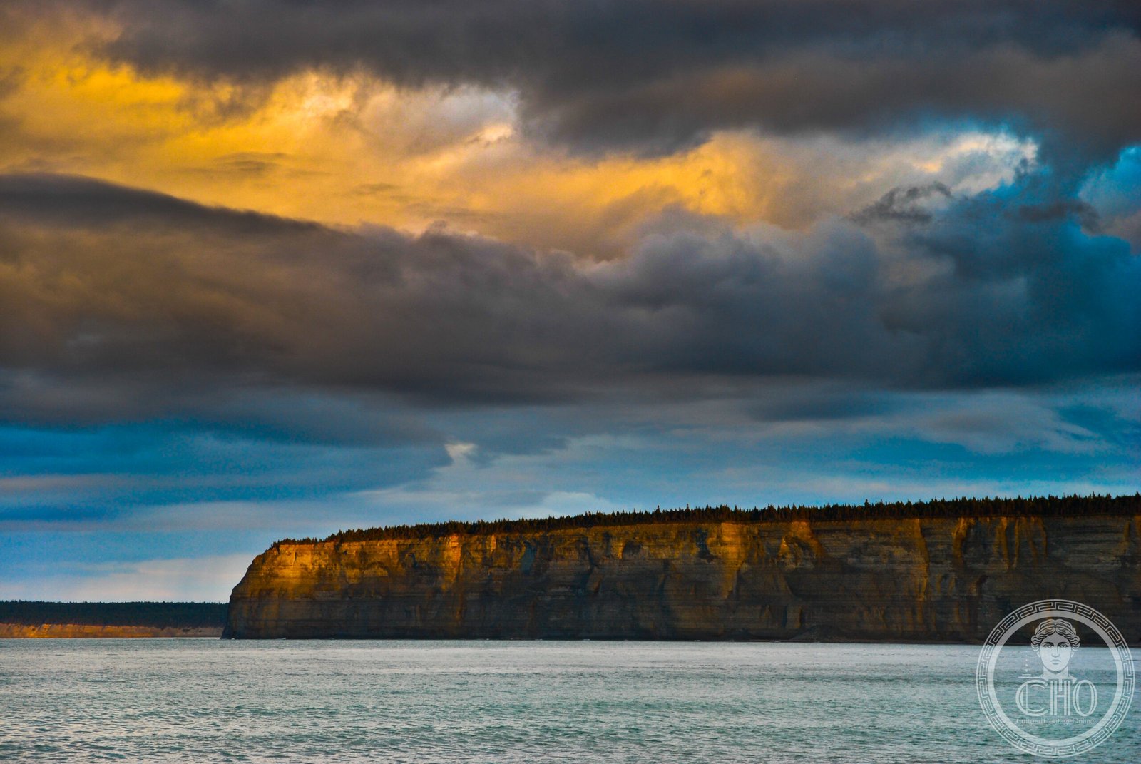
Nell’estuario del Fiume San Lorenzo, a metà strada tra il Québec e la Terranova, l’isola d’Anticosti è grande come la Corsica ma ha solo 200 abitanti. La sua roccia calcarea, depositatasi in un mare tropicale poco profondo tra 450 e 420 milioni di anni fa, espone in falesie costiere e canyon fluviali la sequenza di fossili marini più completa e più accessibile del pianeta per il periodo Ordoviciano-Siluriano. Trilobiti, coralli, crinoidei, braciopodi e i primi vertebrati corazzati (ostracodermi) emergono da strati rocciosi rivelati dall’erosione del fiume e del mare. Patrimonio UNESCO dal 2023.
At a glance
Île d’Anticosti (Anticosti Island) is a large island (7,923 km²) at the mouth of the St Lawrence estuary in Québec, Canada. UNESCO inscribed it in 2023 (ref. 1686) as the world’s most outstanding natural record of marine invertebrate life during the Ordovician and Silurian periods (450–420 million years ago). The island’s horizontal limestone beds are exceptionally well preserved and exposed in coastal cliffs and river canyons, yielding a near-complete stratigraphic record of the major end-Ordovician mass extinction event — the second-largest extinction in Earth history. The fossils are abundant, varied and accessible to non-specialists.
Key facts
- UNESCO: World Heritage since 2023 (Anticosti Island, ref. 1686)
- Age of rocks: 445–420 million years old (Late Ordovician to Late Silurian)
- Mass extinction: the island records the end-Ordovician mass extinction event, which eliminated ~85% of species globally
- Fossils: trilobites, rugose and tabulate corals, crinoids, brachiopods, bryozoans, early fish (ostracoderms)
- Size: 7,923 km² — one of the largest islands in the Gulf of St Lawrence
- Ecology today: dense white-tailed deer population (over 160,000 deer — one of the highest densities in North America)
History
Anticosti Island was known to the Innu people, who called it “Notiskuan” (“where bears are hunted”). French explorer Jacques Cartier passed by in 1534. The island remained sparsely populated through the colonial period; its position at the mouth of the St Lawrence made it a navigational hazard, and hundreds of ships sank on its reefs, earning it the nickname “graveyard of the Gulf.”
In 1873, Henri Menier — a French chocolate magnate — purchased the island for personal use and introduced white-tailed deer, which multiplied explosively. The island was sold to paper companies in the 20th century and most of it was managed for forestry. The exceptional palaeontological value of Anticosti’s limestone beds attracted geologists from the 19th century; the definitive scientific studies from the 1970s onward established its global significance as a Lagerstätte (exceptionally fossiliferous site). Quebec Province and the Canadian federal government prepared and submitted the UNESCO nomination, inscribed in 2023.
What you see
The geological highlights are the river canyons — particularly the Canyon de la Vauréal (75 m deep), one of the most dramatic in eastern Canada — where limestone walls expose the fossil-bearing strata. Fossil hunting on the coastal beaches is permitted (surface collection only); trilobite carapaces, coral heads and brachiopod shells weather out of the cliff face and litter the beaches.
The island also has exceptional wildlife: white-tailed deer in extraordinary numbers, wolves (reintroduced in 1983), river otters and bald eagles. The forests are largely old-growth boreal, with wild rivers for canoeing and salmon fishing.
Practical information
- Access: ferry from Sept-Îles or Rimouski (6–8 hrs) or small aircraft from Sept-Îles or Mont-Joli to Port-Menier airport
- Main village: Port-Menier — the island’s only village; hotels and outfitters based here
- Fossil collecting: permitted for personal/non-commercial surface collection on beaches
- Best time: June–September (ferry and full tourism services); winter access by ski-plane only
Getting there
Fly from Sept-Îles or Mont-Joli, Québec, to Port-Menier Airport on Anticosti (1 hr; scheduled service in summer). Ferry from Sept-Îles (6 hrs) or Rimouski (10 hrs) in summer. GPS (island centre): 49.54° N, 63.25° W.
Nearby
- Gaspé Peninsula — the Parc National de la Gaspésie and Forillon National Park on the Quebec mainland, 80 km south
- Sept-Îles — the gateway city on the North Shore of the St Lawrence, with an Innu cultural centre
- Mingan Archipelago National Park Reserve — the spectacular limestone monolith island chain west of Anticosti on the St Lawrence
Sources
- UNESCO World Heritage Centre — “Anticosti Island” (ref. 1686)
- Geological Survey of Canada — Anticosti Island geological documentation
- Encyclopaedia Britannica — Anticosti Island
Find it on the map
See this place and what’s around it →📷 Diventa un fotografo di Cultural Heritage Online
Condividi le tue foto dei luoghi: restano pubblicate con la tua firma come autore. Più vengono viste, più ti fai conoscere — e presto un concorso premierà le foto più apprezzate.
Accedi o registrati gratis per aggiungere una foto