Atollo di Aldabra (sito naturale): il secondo atollo corallino più grande del mondo
A oltre 1.000 km dalle Seychelles principali, nell’Oceano Indiano occidentale, l’atollo di Aldabra è uno dei luoghi più isolati e incontaminati della Terra. Il secondo atollo corallino più grande al mondo ospita la più grande popolazione di tartarughe giganti in libertà — oltre 100.000 esemplari di Aldabrachelys gigantea — insieme a colonie di uccelli marini unici e a ecosistemi di reef corallino tra i meglio conservati dell’Oceano Indiano. Patrimonio UNESCO dal 1982.
At a glance
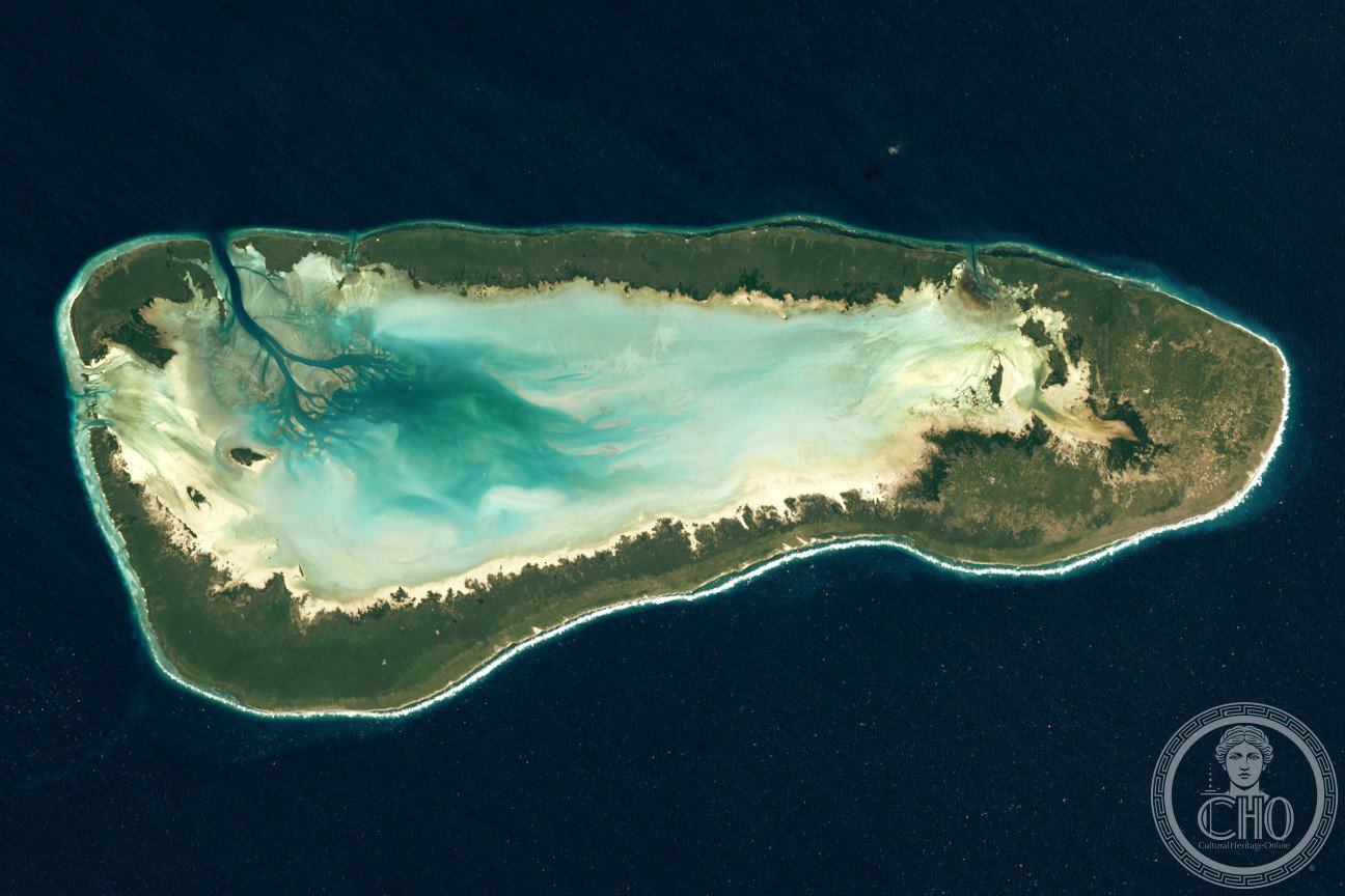
Aldabra is an isolated coral atoll 1,100 km south-west of the main Seychelles island group in the western Indian Ocean. With a total land area of about 155 km² and a lagoon of 224 km², it is the world’s second-largest coral atoll. Aldabra has been almost entirely spared from human disturbance — a proposed RAF airbase in the 1960s was blocked by a scientific campaign — and is now managed by the Seychelles Islands Foundation as a strict nature reserve. Its most celebrated inhabitants are more than 100,000 Aldabra giant tortoises, the last giant tortoise population in the Indian Ocean and one of only two in the world.
Key facts
- UNESCO: World Heritage since 1982 (Aldabra Atoll, ref. 185)
- Size: second-largest coral atoll in the world; lagoon 224 km²
- Giant tortoises: over 100,000 Aldabra giant tortoises — the largest free population on Earth
- Isolation: 1,100 km south-west of Mahé; almost no human habitation
- Biodiversity: endemic species of birds, reptiles and insects; pristine coral reefs
- Managed by: Seychelles Islands Foundation (strict research reserve)
History
Aldabra’s remoteness has been its greatest protector. Arab sailors knew of the atoll by the 10th century, and it appeared on Portuguese charts in the 16th century under the name “Al Hadra.” Its giant tortoises were hunted by passing ships for food from the 17th century onwards, and by the 19th century the Aldabra tortoise was nearly wiped out. After the atoll came under British control via Mauritius, limited exploitation continued (guano mining, copra, sea cucumbers) but never at the industrial scale that destroyed tortoises on other Indian Ocean islands.
In 1966, a plan to build a British and US military airbase on Aldabra was blocked through a coordinated campaign by scientists including David Attenborough and Julian Huxley, who argued the atoll was irreplaceable as a natural laboratory. The islands were placed under strict conservation in 1971 and the Seychelles Islands Foundation took over management after independence in 1976. UNESCO inscribed Aldabra in 1982 as one of the world’s most important natural sites.
What you see
Aldabra is a ring of four main islands of raised fossil coral (champignon, or “mushroom” rock) enclosing a large shallow lagoon. The tortoise population is immediately visible on land: the giant animals graze on low-growing vegetation and congregate at water sources. Frigatebirds, red-footed boobies and the endemic Aldabra rail (the last surviving flightless bird in the Indian Ocean) nest on the atoll.
The coral reefs and lagoon are among the most pristine in the Indian Ocean: rich in fish, manta rays, green turtles (which nest on the beaches) and sharks. Research stations operate by permit; tourism is extremely limited and managed.