Aflaj Irrigation Systems of Oman
Five living examples of an irrigation tradition two-and-a-half millennia old — where water, carved from the earth by hand and governed by customary law, still sustains date palms, communities, and a way of life that predates Islam.
At a glance
The aflaj (singular: falaj) are gravity-fed underground aqueducts that tap aquifers in the Omani highlands and carry water to the surface through shafts and open channels, distributed without pumps or machinery. Oman has approximately 3,000 functioning aflaj — one of the world’s densest concentrations of this ancient water technology. UNESCO inscribed five representative examples in 2006: Falaj Al-Khatmeen, Falaj Al-Malki, Falaj Daris (the largest, near Nizwa), Falaj Al-Jeela, and Falaj Al-Muyassar.
Key facts
- UNESCO inscription: 2006, World Heritage List
- Origin: Introduced from Iran c. 500 BCE; technology derived from the Persian qanat
- Scale in Oman: ~3,000 functioning aflaj nationally
- Falaj Daris: Largest inscribed system, serving Nizwa Oasis
- Water allocation: Customary time-share law measured by sundials
- Primary crop: Date palms; also citrus, vegetables, cereals
- Social role: Mosques and washhouses built alongside channels
History
The falaj tradition entered Oman from Persia roughly 2,500–3,000 years ago. The underlying technology — the qanat — was developed in Iran in the first millennium BCE and spread from Morocco to China. Oman adapted it to exploit aquifers beneath its limestone and granite mountains. By the Islamic period the aflaj were the backbone of Omani civilisation, supporting the great date-palm oases and the city of Nizwa, Oman’s political and religious capital for centuries.
Portuguese occupation of coastal towns in the 16th–17th centuries left the interior oases untouched. The threat came from modernity: after Oman’s 1970 renaissance under Sultan Qaboos, electric pumps allowed faster groundwater extraction than aquifer recharge, lowering water tables and reducing flow in many traditional aflaj. UNESCO inscription in 2006 brought international attention and resources to conservation.
What you see
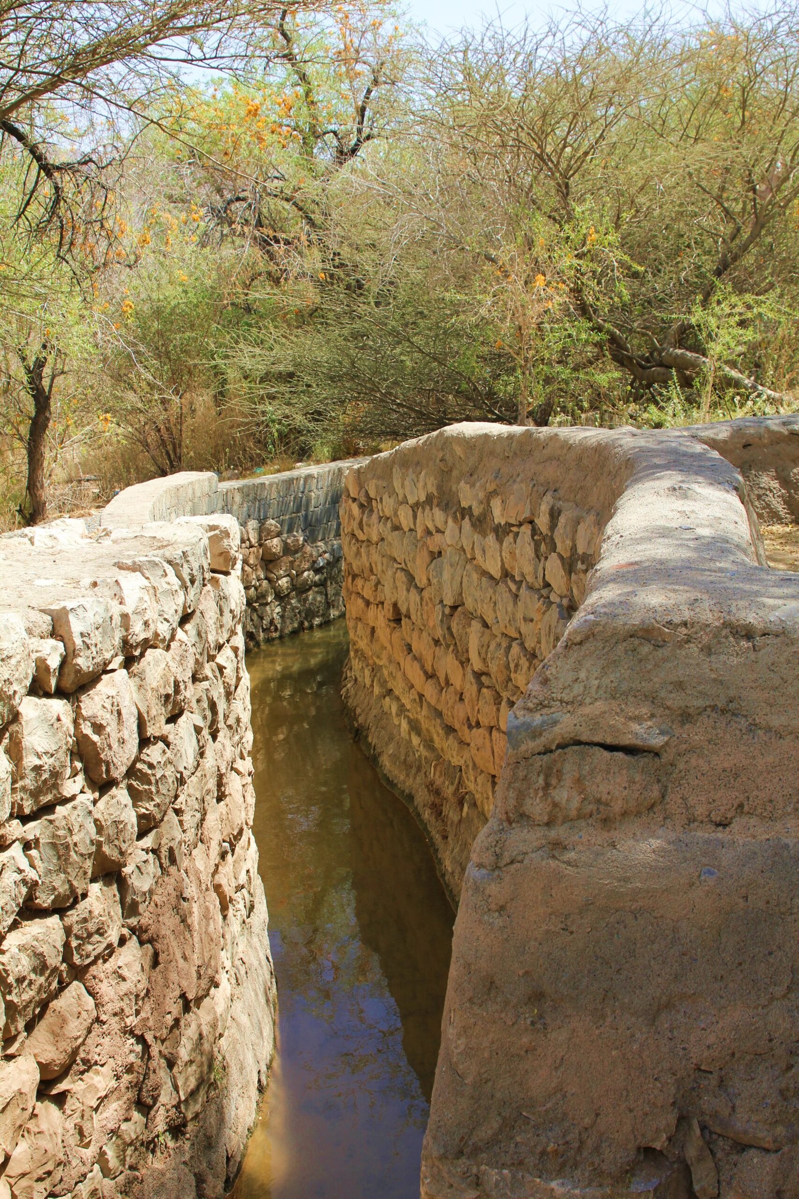
A falaj begins with vertical shafts — some 30–40 metres deep — sunk along an aquifer’s line. At the bottom they connect to a horizontal tunnel (the “mother channel”) sloping gradually downhill. As it approaches the surface it becomes an open stone-lined channel, sometimes no wider than a forearm, carrying a quiet stream through gardens and past mosque walls.
Falaj Daris near Nizwa is the most impressive of the five sites: its main channel runs several kilometres and irrigates one of the largest date-palm gardens in Oman, with the 17th-century Nizwa Fort rising above the palms. Alongside every falaj you will find a sundial — dividing the day into water-shares that each plot holds as a customary entitlement, adjudicated by community elders and recorded in legal documents for centuries.
Living heritage
The Omani aflaj are not ruins — they are working infrastructure, maintained by the communities that depend on them. Wakilat al-falaj (falaj guardians) are still appointed in villages to oversee maintenance and enforce the water-share schedule. Each falaj is legally owned by its community under principles of collective stewardship rooted in Islamic property law and pre-Islamic Omani custom. Cleaning the underground tunnels requires workers to descend through maintenance shafts and remove sediment by hand — a dangerous craft passed across generations. UNESCO’s inscription recognised this intangible dimension — governance, legal traditions, seasonal labour rhythms — as integral to the heritage.
Practical information
- Best visited: October–March (cooler months; date harvest September–October)
- Base: Nizwa is the most accessible hub; Falaj Daris is within walking distance of Nizwa Fort and Souq
- Transport: Hire car recommended; Nizwa is 164 km from Muscat (c. 1.5 hours on Highway 15)
- Combine with: Nizwa Fort, Nizwa Souq, Bahla Fort, Jabrin Castle
- Respect: Channels pass through private gardens and mosques — dress modestly and do not enter private property
Getting there
Nizwa lies 164 km south-west of Muscat on Highway 15 — approximately 1.5 hours by car. Public buses connect from Muscat’s Ruwi Bus Station, but a hire car offers greater flexibility. Falaj Al-Muyassar lies near Rustaq in the Al Batinah region (c. 170 km from Muscat). Muscat International Airport (MCT) has direct connections to most major European, Asian, and Gulf hubs.
Nearby
- Bahla Fort — UNESCO WHS; massive mudbrick fortress 45 km west of Nizwa
- Jabrin Castle — 17th-century palace-fortress with painted ceilings, 35 km west
- Archaeological Sites of Bat, Al-Khutm and Al-Ayn — Bronze Age necropolis (UNESCO WHS), 100 km west
- Wadi Ghul and Jebel Shams — Oman’s Grand Canyon and highest peak, c. 90 km west
- Al Hamra and Misfah al Abriyeen — preserved mudbrick villages at the Hajar Mountains foothills
Sources
- UNESCO World Heritage Centre — Aflaj Irrigation Systems of Oman (List No. 1207)
- Wikipedia — Aflaj irrigation systems of Oman
- Wilkinson, J.C. — Water and Tribal Settlement in South-East Arabia (Oxford, 1977)
Find it on the map
See this place and what’s around it →📷 Diventa un fotografo di Cultural Heritage Online
Condividi le tue foto dei luoghi: restano pubblicate con la tua firma come autore. Più vengono viste, più ti fai conoscere — e presto un concorso premierà le foto più apprezzate.
Accedi o registrati gratis per aggiungere una foto