Punic Port of Carthage
The Punic ports of Carthage are the remnants of the twin harbour complex that made ancient Carthage one of the most powerful maritime states in the Mediterranean world from roughly the 4th century BC until the city’s destruction by Rome in 146 BC. Comprising a rectangular commercial harbour and a circular military harbour — the latter known as the Cothon — the ports were among the most sophisticated naval installations of antiquity, capable of sheltering over 200 warships in covered ship-sheds. The site, in modern-day Tunis, Tunisia, forms part of the UNESCO World Heritage archaeological zone of Carthage.
At a glance
- Type
- Archaeological site — ancient military and commercial harbour
- Period
- Active c. 4th–2nd century BC; destroyed 146 BC; excavated from the 1970s onward
- Style
- Punic military and hydraulic engineering
- Location
- Carthage, Tunis Governorate, Tunisia — 36.8450° N, 10.3255° E
Overview
Ancient Carthage was founded by Phoenician colonists from Tyre (traditionally in 814 BC) on a peninsula on the eastern shore of the Lake of Tunis, and its commercial and military power rested entirely on its mastery of the sea. The two-harbour system — a large rectangular commercial basin to the north and a circular military basin (the Cothon) to the south — was described in detail by Appian and partially confirmed by 20th-century excavation. The circular military harbour contained a central island (the admiral’s island) ringed by ship-sheds; ancient sources report capacity for 220 warships. Both basins were connected to each other and to the sea through navigable channels, forming an integrated naval infrastructure unparalleled in the ancient western Mediterranean.
History
Carthage emerged as the leading Phoenician colony in the western Mediterranean by the 6th century BC, and its harbour facilities grew in sophistication alongside its naval ambitions. The First Punic War (264–241 BC) against Rome demonstrated Carthaginian naval power at scale; the fleet launched from these ports during the Second Punic War (218–201 BC) supported Hannibal’s campaigns from Spain to Italy. After the catastrophic defeat in the Third Punic War, Roman forces razed Carthage to the ground in 146 BC, filling in the harbours and salting the surrounding land — though the Roman colony of Carthago later rose on the same site and reused elements of the Punic harbour system. British and French archaeological teams from the 1970s (the UNESCO Save Carthage campaign) excavated substantial remains of the military harbour island and ship-sheds.
What you see
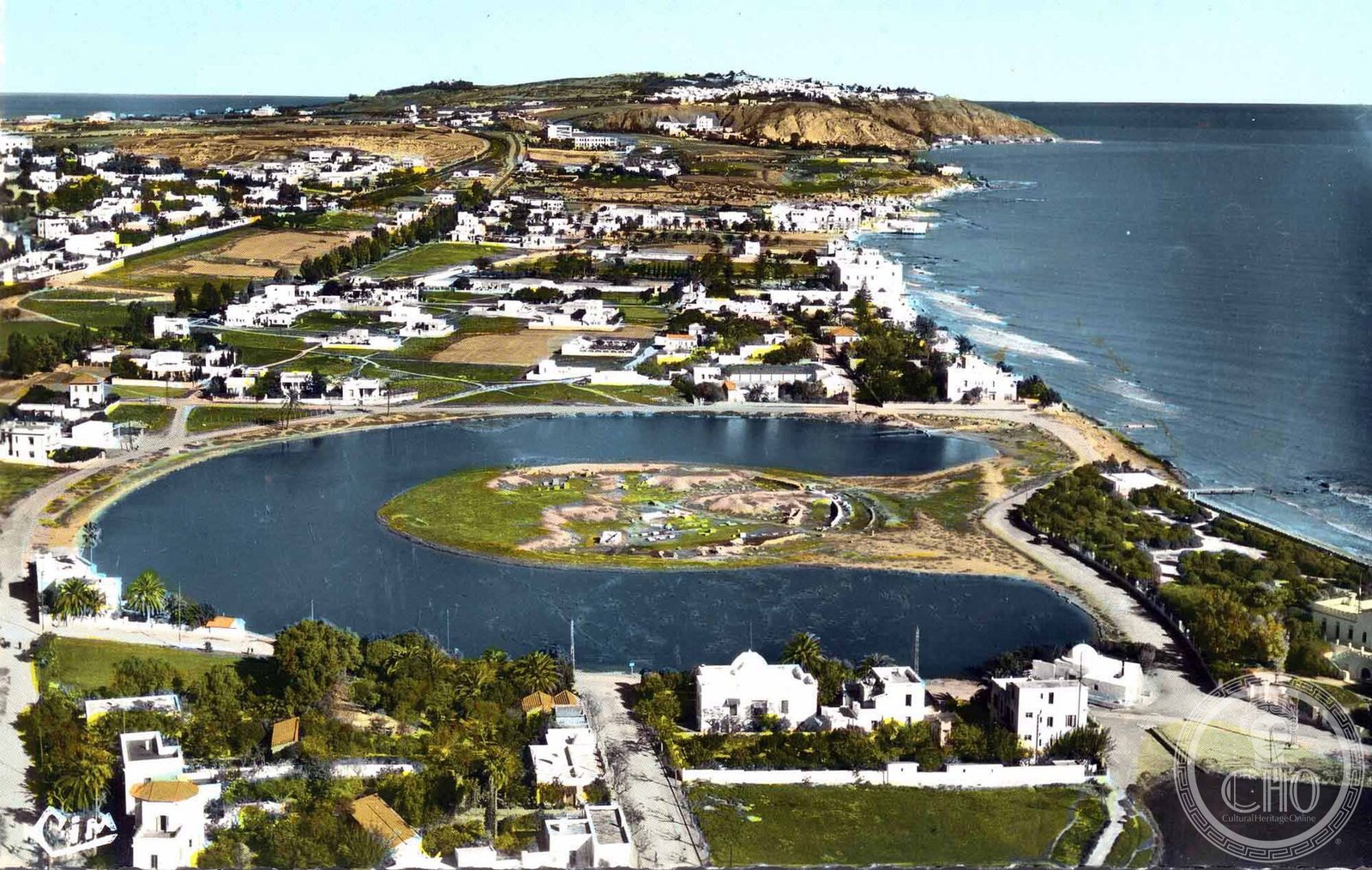
The circular military harbour (Cothon) survives as a lagoon approximately 325 metres in diameter, with the central admiral’s island still visible and partially excavated. On the island, foundations of ship-sheds — rows of parallel stone channels for hauling warships ashore — were uncovered by excavation and are preserved in situ. The rectangular commercial harbour to the north is today largely silted but retains its outline; along its former quays, Roman and Punic quayside structures have been identified. The Oceanographic Museum of Carthage (Musée de Carthage) near the harbours displays artefacts from the excavations. The wider site also encompasses Roman baths, villas, and the Tophet sanctuary.
Cultural significance
The Punic harbours are a rare surviving example of ancient naval engineering at the scale of a great Mediterranean power and provide irreplaceable evidence of Phoenician-Punic seafaring technology, shipbuilding, and strategic port planning. The UNESCO inscription of Carthage (1979) recognises the outstanding universal value of the site as the capital of a civilisation that shaped the political history of the Mediterranean for over five centuries and whose legacy survives in North African, Spanish, and Sardinian material culture. The harbours are considered by scholars one of the most important military archaeological sites in the ancient world.
Practical information
- Address
- Carthage, Gouvernorat de Tunis, Tunisia
- Museum
- Musée de Carthage, Byrsa Hill — check official website for current hours and admission fees
- UNESCO zone
- Archaeological Site of Carthage — UNESCO World Heritage (1979)
- Coordinates
- 36.8450° N, 10.3255° E
Getting there
Carthage is located approximately 15 km northeast of Tunis city centre and is accessible via the TGM light railway (Tunis–Goulette–Marsa line), which stops at Carthage-Hannibal, Carthage-Présidence, and Carthage-Dermech stations within easy walking distance of the main archaeological zones. By car from Tunis, take the coastal road (Route de la Corniche) north from La Goulette. Tunis-Carthage International Airport is approximately 5 km from the Carthage archaeological site.
Sources & resources
Find it on the map
See this place and what’s around it →📷 Diventa un fotografo di Cultural Heritage Online
Condividi le tue foto dei luoghi: restano pubblicate con la tua firma come autore. Più vengono viste, più ti fai conoscere — e presto un concorso premierà le foto più apprezzate.
Accedi o registrati gratis per aggiungere una foto