Parco Nazionale Desembarco del Granma (sito naturale): le terrazze marine preistoriche e le foreste tropicali del Cuba sud-occidentale
Nel promontorio sud-occidentale di Cuba, dove la Sierra Maestra scende a picco sul Mar dei Caraibi, il Parco Nazionale Desembarco del Granma custodisce la serie più completa al mondo di terrazze marine sollevate — antiche barriere coralline tropicali portate in quota fino a 450 metri dal lento sollevamento tettonico. Sette terrazze sovrapposte come le pagine di un libro geologico raccontano 8 milioni di anni di storia del livello del mare. Lo stesso promontorio fu teatro della storia: il 2 dicembre 1956 la motonave Granma, con 82 guerriglieri a bordo tra cui Fidel Castro e Ernesto Che Guevara, approdò qui dando inizio alla Rivoluzione Cubana. Patrimonio UNESCO dal 1999.
At a glance
Desembarco del Granma National Park covers 32,651 hectares in south-western Cuba (Granma and Santiago de Cuba provinces). UNESCO inscribed it in 1999 (ref. 889) for its outstanding geological and natural values: it possesses the most complete and best-preserved series of raised marine terraces in the world, with seven terraces rising to 450 m above sea level and a series of submarine terraces extending 180 m below the surface. The terraces contain some of the western hemisphere’s best-preserved fossil coral reefs, abundant cave systems, and important pre-Columbian archaeological sites with petroglyphs and Taíno cultural artefacts. The park also has significant tropical dry forest and semi-deciduous forest biodiversity.
Key facts
- UNESCO: World Heritage since 1999 (Desembarco del Granma National Park, ref. 889)
- Marine terraces: 7 raised terraces from sea level to 450 m; the most complete series in the world
- Geological age: terraces formed over 8 million years; show sea-level changes through multiple glacial cycles
- Pre-Columbian: Taíno cave petroglyphs and archaeological sites throughout the park
- Historical: the landing site of the revolutionary yacht Granma (2 December 1956), carrying Castro’s guerrillas to begin the Cuban Revolution
- Flora: tropical dry forest and matorral; significant number of endemic Cuban plant species
History
The area was inhabited by the Taíno people before the Spanish conquest of Cuba in the 1500s. Taíno communities used the caves as ceremonial spaces and for habitation; their petroglyphs — incised into the limestone walls — depict anthropomorphic figures and animals. Spanish colonisation and the subsequent disappearance of the Taíno through disease, enslavement and assimilation erased most of their living culture, but the cave sites survived.
The modern history of the park is inseparable from the Cuban Revolution. On December 2, 1956, the motor yacht Granma arrived off Las Coloradas beach with 82 combatants aboard, including Fidel Castro, Che Guevara and Camilo Cienfuegos. The landing was poorly concealed; within three days, Batista’s army had killed or captured most of the party. The surviving 12–20 guerrillas fled into the Sierra Maestra and began the revolution. The park was established in 1980 and inscribed as UNESCO World Heritage in 1999.
What you see
The geological centrepiece is the terrace landscape: walking the trails from sea level to the upper terraces reveals the successive fossil coral formations, with brain corals, staghorn corals and bivalves preserved in the limestone walls. The lowest terrace is still partly submerged and forms the reef coast. The highest terrace commands panoramic views over the Caribbean.
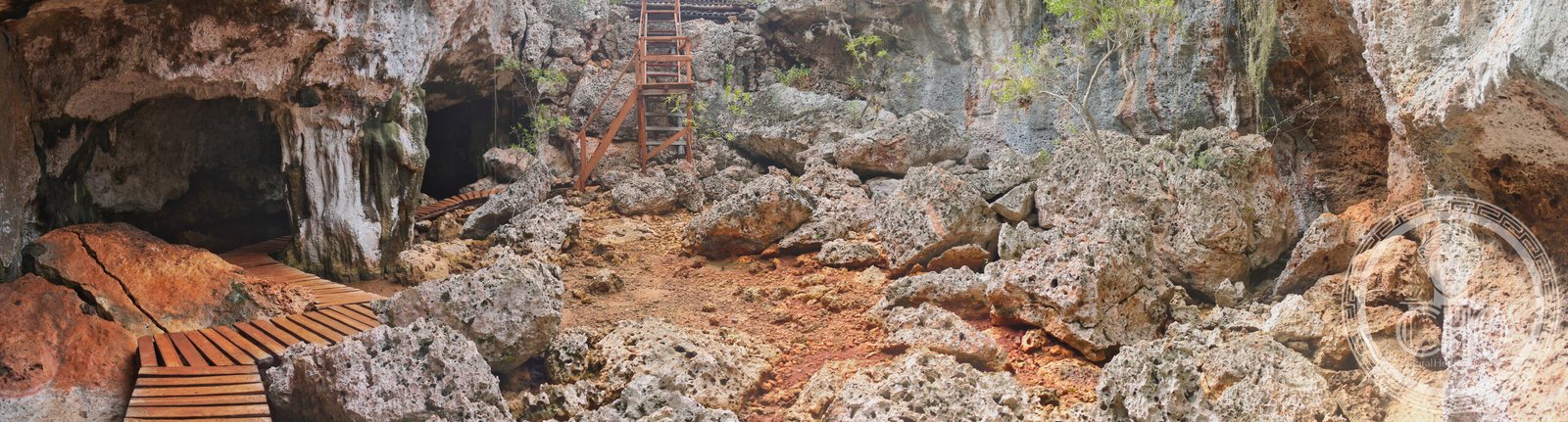
The Taíno cave sites — particularly the Cueva del Guafe and Cueva de los Petroglifos — are accessible by guided tour and preserve some of the best-documented Taíno rock art in the Caribbean. The landing site at Las Coloradas beach has a replica of the Granma yacht and a memorial.
Practical information
- Base: Niquero or Media Luna (small towns near the park); accommodation at Campismo Las Coloradas within the park
- Access from Havana: 850 km east; fly to Manzanillo or Bayamo (Granma Province), then drive south (2 hrs)
- Guided tours: required for cave sites; available from the park visitor centre at Las Coloradas
- Best time: November–April (dry season; cooler; trails accessible)
Getting there
Fly to Manzanillo or Bayamo airports from Havana (1 hr; Cubana de Aviación). Drive south from Manzanillo via Niquero to Las Coloradas (2 hrs). GPS: 19.88° N, 77.63° W.
Nearby
- Sierra Maestra — the mountain range where Castro’s guerrillas established their base after the Granma landing; La Plata command headquarters open to visitors
- Santiago de Cuba — Cuba’s second city, 150 km east; historic centre with the oldest cathedral in Cuba and the Moncada Barracks
- Old Havana (UNESCO) — the colonial capital, 850 km west
Sources
- UNESCO World Heritage Centre — “Desembarco del Granma National Park” (ref. 889)
- Encyclopaedia Britannica — Cuba; Cuban Revolution
- Parques Nacionales de Cuba — Desembarco del Granma
Find it on the map
See this place and what’s around it →📷 Diventa un fotografo di Cultural Heritage Online
Condividi le tue foto dei luoghi: restano pubblicate con la tua firma come autore. Più vengono viste, più ti fai conoscere — e presto un concorso premierà le foto più apprezzate.
Accedi o registrati gratis per aggiungere una foto