Angkor
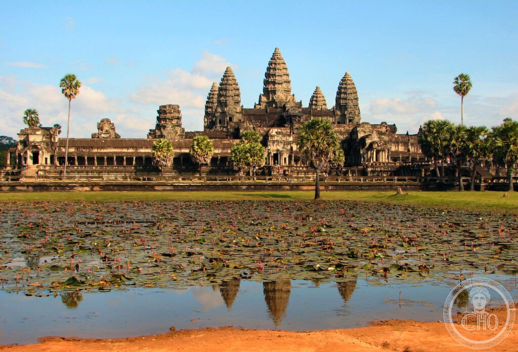
The largest religious monument ever built and the defining achievement of Southeast Asian civilisation — Angkor, the capital of the Khmer Empire from the 9th to the 15th centuries, spans 400 km² and encompasses Angkor Wat (the single largest religious building in the world), Angkor Thom with the Bayon temple (the city of 216 giant stone faces), Ta Prohm (the temple where the jungle has been deliberately left to grow through the stones), and hundreds of further temples, reservoirs, and palaces.
At a glance
The Angkor Archaeological Park (UNESCO WHS 1992; approximately 400 km² in the Siem Reap Province of northern Cambodia; the most extensive archaeological landscape in the world (larger than any other pre-industrial settlement in history; at its peak, approximately 12th–13th century CE, the Angkor urban complex had a population estimated at 0.1–0.9 million (the most recent archaeological estimate, based on lidar surveys and urban density models, suggests the densely inhabited area could have supported 700,000–900,000 people — if the higher estimate is correct, Angkor was the largest pre-industrial settlement in world history, larger than medieval London, Paris, or Beijing)); the Khmer Empire (802–1431 CE; the most powerful empire in the history of Southeast Asia; founded by Jayavarman II (r. 802–850 CE; the first Khmer king to claim “devaraja” (divine king) status — the most important political innovation in Southeast Asian history; the claim that the king was an incarnation of Shiva or Vishnu placed the Khmer state in direct ritual competition with the major Indian empires and gave the monarchy a religious legitimacy that persisted for 600 years); the capital (the Khmer capital was at Angkor or nearby for approximately 600 years; the most remarkable urban continuity in Southeast Asian history; the city was served by the world’s most sophisticated pre-industrial water management system (the baray (the great rectangular reservoirs; the West Baray (8 km × 2.1 km; 50 million m³; the largest ancient reservoir in the world; still holding water after 1,000 years)); the fall (the Khmer capital was abandoned c.1431 after the Thai Ayutthaya kingdom sacked Angkor; the causes are debated but include drought (the disruption of the water management system) and political fragmentation; the discovery (the French naturalist Henri Mouhot (1826–1861) popularised the ruins of Angkor to the Western world in 1861 — his diaries describe his astonishment at the ruins; the temples had never been lost to local Cambodians (they remained active Buddhist pilgrimage sites throughout the “abandonment” period).
Key facts
- Angkor Wat’s bas-reliefs: the longest continuous bas-relief narrative in the world — the bas-reliefs (the gallery of bas-reliefs on the third enclosure of Angkor Wat; 8 panels; total length approximately 800 m; approximately 2 m high; the finest and most extensive bas-relief cycle in Southeast Asian art; the subjects (the eight panels are arranged around the four cardinal and diagonal points; the most important: the south gallery (the Battle of Kurukshetra (the climactic battle of the Hindu epic Mahabharata; the longest single narrative scene in the Angkor Wat reliefs); the Churning of the Sea of Milk (the creation myth of Hinduism in which gods and demons churn the cosmic ocean to extract the elixir of immortality; 91 demons and 88 gods pulling the naga serpent Vasuki around Mount Mandara (the churning stick); the 1,500-year-old story carved with the narrative economy and visual intelligence of the finest Khmer workshop); the army of Suryavarman II (the south-west gallery; the king reviewing his troops; the first historical scene in the reliefs and the primary source for the appearance of the Khmer army)); the condition (the bas-reliefs are the best-preserved surface in Angkor Wat; the deeply carved sandstone has survived 900 years of humidity, monsoon, and (at one end) bat guano better than the freestanding towers; the most important ongoing conservation challenge is the dissolution of the sandstone by biological organisms (fungi, algae, lichen))
- The Bayon and the Face Towers: the most surreal architectural experience in Southeast Asia — the Bayon (the state temple of Angkor Thom; built by Jayavarman VII (r. 1181–1218 CE; the most prolific builder in the history of the Khmer Empire; the converter of the empire from Hinduism to Mahayana Buddhism; the builder of Angkor Thom, the Bayon, Ta Prohm, Preah Khan, and the hospital chapels); the towers (the Bayon has 54 towers; each tower has four faces (one facing each cardinal direction); the total (54 × 4 = 216 faces; the largest single assembly of identical faces in the history of world architecture); the identity (the faces have been variously identified as representations of the bodhisattva Avalokitesvara (the most important bodhisattva in Mahayana Buddhism; the deity of compassion), of Jayavarman VII himself, or of the combination of both (a devaraja portrait in Buddhist guise)); the bas-reliefs (the Bayon bas-reliefs are carved on a lower gallery than the Angkor Wat reliefs and depict historical rather than mythological scenes; the most important panel: the battle on the Tonlé Sap lake (the naval battle between the Khmer and the Cham (Vietnamese kingdom) forces; the most vivid military scene in Khmer art; the depiction of crocodiles eating the bodies of the drowned and of the daily life on the lake shore (fishing, cooking, gambling, playing chess) is the finest genre scene in Khmer relief carving))
- Ta Prohm: the temple that the jungle reclaimed — Ta Prohm (built by Jayavarman VII c.1186 CE; originally known as Rajavihara (the royal monastery); used for the Buddhist education of monks; the decision to leave Ta Prohm partially uncleared (unlike the other major temples) was made by the École française d’Extrême-Orient in the early 20th century as a deliberate aesthetic choice (to demonstrate what the Angkor temples looked like when the French discovered them overgrown with jungle); the result is the most photographed single image in Angkor (the vast silk-cotton and strangler fig trees (Ficus sp.) whose roots have grown over and through the stone galleries over the course of 700 years; the most photographed individual tree at Angkor: the “Tomb Raider tree” (the strangler fig growing over the gallery doorway used as the set for the 2001 film Lara Croft: Tomb Raider (the most influential single factor in the surge of adventure-tourist visitors to Angkor in the early 21st century)); the conservation dilemma (the trees are both damaging the stone (the roots break the masonry as they grow) and protecting it (the root systems hold the walls together; removing the trees would cause immediate structural collapse in the most affected areas; the JASA Japanese conservation team and the ASI Indian team have taken different approaches to this dilemma in their respective areas of the temple))
- Heritage: UNESCO World Heritage Site, Angkor, inscribed 1992
- GPS: 13.4125° N, 103.8670° E
History
The founding of the Khmer Empire (802 CE; Jayavarman II; the devaraja cult; the capital moved to the Angkor region (the word “Angkor” is the Khmer pronunciation of the Sanskrit “nagara” (city; capital))); the water management system (the most important infrastructure in the Khmer Empire; the baray (the great rectangular reservoirs); the canal system; the ability to irrigate multiple rice harvests per year — the agricultural surplus that funded the temple-building programme); the golden age (12th–13th centuries; the reigns of Suryavarman II (Angkor Wat) and Jayavarman VII (Angkor Thom; the Bayon; Ta Prohm; the hospital system — Jayavarman VII built 102 hospitals across the empire (described in inscriptions as providing free care to all Khmer people; the most ambitious public health programme of the pre-modern world in Southeast Asia)); the decline (13th–15th centuries; the Mongol invasions (1283; repelled); the Tai (Thai) invasions; the drought (lidar surveys reveal that the water management system was disrupted by climate change-related drought in the 14th–15th centuries; the most important structural cause of the Angkor collapse); the abandonment (c.1431; UNESCO WHS 1992.
What you see
The classic two-day Angkor itinerary: Day 1 (the “Small Circuit”; Angkor Wat (the sunrise visit from the west reflecting pool is the essential experience; arrive 1h before dawn; the silhouette of the five towers reflected in the pool is the most photographed image in Southeast Asia; allow 3h inside the monument); the Bayon (allow 1h 30min; early morning after Angkor Wat before the heat builds); Ta Prohm (allow 1h; in the afternoon light (the trees filter the late afternoon sun dramatically))); Day 2 (the “Big Circuit”; Preah Khan (the forest temple with long galleries; the least visited of the major temples); the Neak Pean (the island temple in the middle of the Jayatataka baray); Banteay Kdei (smaller and less restored; the most atmospheric of the medium-size temples)). The must-see additions: Banteay Srei (25 km north; the temple of pink sandstone with the finest figurative carving in Cambodia; the temple was not visited by early Western travellers because of its remote location; the single most important individual building at Angkor for sculptural quality; allow 1h 30min each way by tuk-tuk from Siem Reap).
Practical information
- Getting there: Siem Reap International Airport (SAI; the new airport 47 km south-east of Siem Reap, opened 2023; international flights from Bangkok, Singapore, Kuala Lumpur, Hong Kong, Seoul, Tokyo; the old airport (REP; closer to the city; now largely non-operational); the tuk-tuk (the standard transport in Siem Reap for both city travel and the Angkor temples; negotiate the full-day rate (approximately USD 15–20 for the Small Circuit; USD 20–25 for the Big Circuit + Banteay Srei) at the guesthouse the night before; the standard and most comfortable transport at Angkor); the Angkor pass (available from the Angkor Enterprise ticket office (NOT at the temples; at the entrance road 4 km from the town); 1-day USD 37; 3-day USD 62; 7-day USD 72; the 3-day pass is the most economical for the main circuit; the pass includes a biometric photo; no shared or family tickets)
- The Khmer kitchen: the most nuanced cuisine in Southeast Asia — Cambodian (Khmer) cuisine in Siem Reap (the essential dishes: amok trey (the most famous Cambodian dish; freshwater fish (from the Tonlé Sap lake; the most productive freshwater fishery in Southeast Asia; the lake shrinks dramatically in the dry season and floods to 4× its dry-season area in the wet season — the most dramatic seasonal lake in Asia) steamed in a banana leaf with kroeung (the lemongrass paste: lemongrass, galangal, kaffir lime leaf, turmeric, shallots, garlic) and coconut cream; the texture is a mousse; the flavour is subtle and complex); fish tasting (the Tonlé Sap lake is the source of approximately 70% of Cambodia’s freshwater fish protein; the most important ecological resource in Cambodia; the fish-fermentation tradition (prahok (the fermented fish paste; the most important single condiment in Khmer cooking; described as “Cambodian cheese” by the foreign food press; the smell is extremely powerful; the flavour is umami-rich and irreplaceable in traditional Khmer cooking; the most important traditional food in Cambodia)); the Siem Reap restaurant scene (the most internationally sophisticated Cambodian city after Phnom Penh; the best restaurants for traditional Khmer food are in the alley behind Pub Street (the most tourist-saturated street) — one block away from the main tourist strip))
- The Tonlé Sap Lake: the ecological heartland of Cambodia — the Tonlé Sap (the “Great Lake”; the largest freshwater lake in Southeast Asia; 2,700 km² in the dry season; approximately 16,000 km² at the peak of the wet season (a 6× increase; the most dramatic seasonal change of any lake in the world); the Tonlé Sap River (the only river in the world that reverses direction seasonally; during the dry season (November–June), the lake drains south into the Mekong via the Tonlé Sap River; during the wet season (June–November), the Mekong’s flood forces the flow to reverse and the lake fills; the reversal ceremony (Bon Om Touk — the Water Festival; the most important festival in Cambodia; held in November at the moment of the flow reversal; boat races on the Tonlé Sap River in Phnom Penh and Siem Reap); the floating villages (the Chong Khneas and Kampong Phluk villages; the most visited from Siem Reap; the entire village moves with the lake level over the course of the year — the most unusual living arrangement in Asia; some villagers have never set foot on dry land for months at a time))
Getting there
Siem Reap Airport SAI (47km from city; flights from Bangkok/Singapore/KL/HK). Angkor pass at ticket office on entrance road (not at temples); 1-day USD 37; 3-day USD 62. Tuk-tuk full day USD 15–25. GPS: 13.4125, 103.8670.
Nearby
- Phnom Penh and the Tuol Sleng Genocide Museum — 320 km south of Siem Reap (5h by bus; 1h by flight); the capital of Cambodia and the most important memorial to the Khmer Rouge genocide — Phnom Penh (the capital; population approximately 2.3 million; the National Museum of Cambodia (the finest collection of Khmer art in the world; surpasses even the Guimet in Paris and the British Museum in the depth of the Khmer sculpture collection; the most important single visit in Phnom Penh); the Royal Palace (1866; the official residence of the King of Cambodia; the Silver Pagoda (Wat Preah Keo Morakot; the floor of the pagoda is covered with approximately 5,000 silver tiles (each weighing approximately 1 kg; total weight 5 tonnes of silver; the most remarkable floor in Asia)); the Tuol Sleng Genocide Museum (the former S-21 prison and interrogation centre; the most important memorial to the Khmer Rouge genocide (1975–1979; the most intense episode of mass killing relative to total population in the 20th century; approximately 1.7 million people died (approximately 21% of Cambodia’s population in 4 years); S-21 was a former high school converted to a torture and interrogation centre; approximately 17,000 prisoners entered S-21; approximately 12 survived (the most survivors ever documented from a systematic extermination facility); the photographs (the systematic mugshots of every prisoner on arrival at S-21; the most important visual archive of genocide in the world (every face is documented; the archive is a unique resource for identification of victims by surviving relatives)))
- Preah Vihear Temple (UNESCO WHS 2008) — 230 km north of Siem Reap (4h by car to the Thai border); the most spectacularly sited Khmer temple in the world — Preah Vihear (the Khmer temple on the edge of the Dangrek Escarpment; built between the 9th and 12th centuries CE; the site (the temple sits at the edge of a 500-m cliff on the Thai-Cambodian border; the most spectacular natural setting of any Khmer monument; the approach (the series of causeways and gopuras (gateway towers) descending the cliff face over 800 m; the finest approach sequence to any temple in Southeast Asia; the view from the main sanctuary (the most important single view in Cambodian archaeology — the temple faces north (contrary to the typical south-facing Khmer orientation) and the view from the sanctuary is directly into Thailand with the Cambodian plain 500 m below))
- Luang Prabang (UNESCO WHS 1995) — 400 km north of Siem Reap (1h flight from Siem Reap to Luang Prabang International Airport); the most perfectly preserved royal Buddhist city in Southeast Asia — Luang Prabang (the former royal capital of Laos; population approximately 56,000; the historic town (the most intact Indochinese colonial and traditional urban fabric remaining in Southeast Asia; the UNESCO WHC inscription (1995) specifically called out the “remarkable degree of integrity” of the town’s physical fabric); the morning alms-giving ceremony (the tak bat; 5:30–6:30 AM; the procession of saffron-robed monks through the streets collecting rice from the townspeople; the most important Buddhist ritual experience for visitors in Southeast Asia; the commercial exploitation of the ceremony (the most photographed act of Buddhist practice in Laos; the presence of large numbers of tourists has created ethical debate about the voyeurism involved; the best approach (observe from a distance, do not photograph at close range, do not participate unless you have rice ready and know the correct protocol))
Sources
- Wikipedia, Angkor Wat; Angkor Thom; Khmer Empire; Ta Prohm, accessed June 2026
- UNESCO, Angkor, WHS reference 668, inscribed 1992
- Michael D. Coe, Angkor and the Khmer Civilization, Thames & Hudson, 2003
Find it on the map
See this place and what’s around it →📷 Diventa un fotografo di Cultural Heritage Online
Condividi le tue foto dei luoghi: restano pubblicate con la tua firma come autore. Più vengono viste, più ti fai conoscere — e presto un concorso premierà le foto più apprezzate.
Accedi o registrati gratis per aggiungere una foto