Necropolis of the Banditaccia
One of the ancient world’s largest burial grounds, this Etruscan necropolis reveals centuries of funerary practice through monumental tombs carved into tuff and lined along a 2-kilometre sepulchral road.
At a glance
The Banditaccia necropolis spans from the 9th century BC through the Hellenistic-Roman period, documenting the evolution of Etruscan burial customs and architecture. A continuous street of tombs stretches over two kilometres, revealing the social hierarchy and artistic sophistication of ancient Caere through chamber burials, tumuli, and dice-shaped monuments aligned with cadastral roads.
History
The necropolis developed in distinct phases. Early burials from the 9th century BC employed well tombs with incineration in biconical vessels and pit graves for inhumation. From the 7th century BC, the inhumation rite gained prevalence, prompting construction of large tumuli with burial chambers carved into the local tuff and decorated with domestic architectural motifs.
By the 6th century BC, medium and small tumuli were flanked by increasingly regular dice-like tombs aligned along the sepulchral road. The 4th century BC saw the widespread adoption of hypogea—single-chamber underground tombs with wall-mounted burial slots—though monumental tombs for noble families remained occasional focal points within the necropolis.
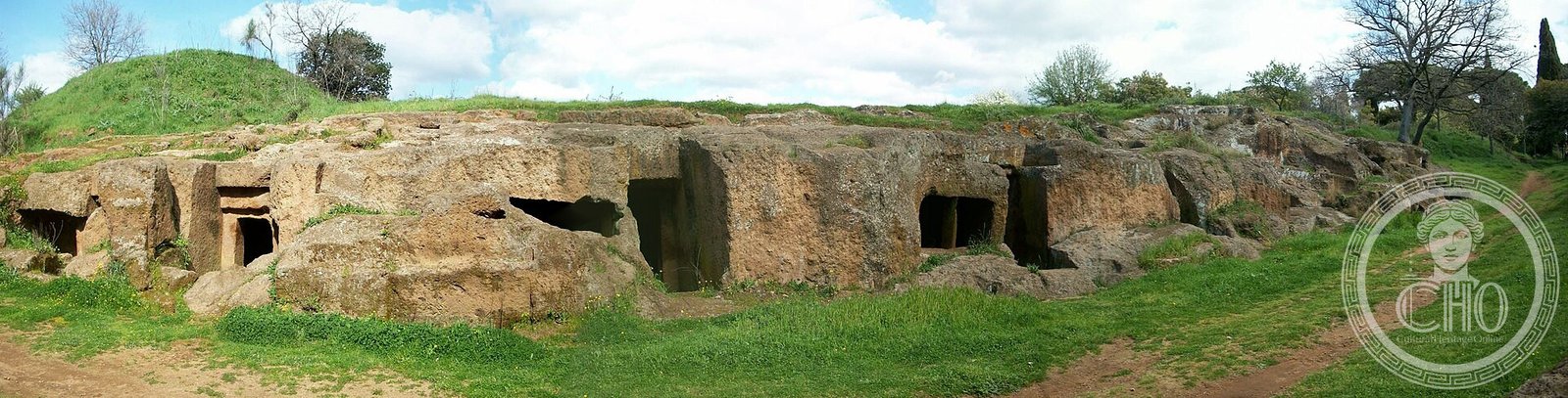
What you see
The Tomb of the Reliefs, situated within the Recinto della Banditaccia, stands as a masterwork of Etruscan funerary decoration. Its walls display stucco reliefs and paintings depicting everyday domestic objects with remarkable naturalism and detail.
Among other notable monuments are the Tomb of the Alcova, the Tomb of the Sarcophagi, the Tomb of the Triclinium, and the Tomb of Tamsnie—each offering evidence of the sophisticated funerary practices of ancient Caere. The arrangement of tombs along their cadastral street preserves the spatial organization of an ancient community laid out for eternity.
Cultural significance
The Banditaccia necropolis documents the social, religious, and artistic values of Etruscan civilization through four centuries of continuous use. Rich grave goods—including imported materials from the Near East and Greece—attest to trade networks and the wealth of Caere’s elite. The varied tomb types reflect evolving religious beliefs and changing social structures across successive periods.
In 2004, the necropolises of Cerveteri and Tarquinia were jointly inscribed on the UNESCO World Heritage List as the first sites specifically recognizing Etruscan civilization’s archaeological and cultural importance.
Key facts
- Address: via della Necropoli, 43/45, 00052 Cerveteri
- Coordinates: 42.0068923, 12.1003695
- Phone: +39 06 9940001
- Official website: https://www.beniculturali.it
- UNESCO World Heritage List: Inscribed 2004
Practical information
Admission: €8.00 (€2.00 for minors; €5.00 for students). Hours: Tuesday–Sunday, 8:30 a.m.–7:30 p.m. (summer); 8:30 a.m.–4:30 p.m. (winter). Closed Mondays. Ticket office hours: 8:30 a.m.–6:30 p.m. (summer); 8:30 a.m.–3:30 p.m. (winter). Booking is optional; reservations can be made by phone or email.
Getting there
Cerveteri is located in Lazio, approximately 40 kilometres north of Rome. The site is accessible by car via the Aurelia road or by regional train and local bus. Detailed directions and parking information should be confirmed via the official website or by contacting the site directly.
Sources & resources
- Official site—Ministero della Cultura
- Cultural Heritage Online
- UNESCO World Heritage Centre listing
Find it on the map
See this place and what’s around it →Historical events at this place (3)
📷 Diventa un fotografo di Cultural Heritage Online
Condividi le tue foto dei luoghi: restano pubblicate con la tua firma come autore. Più vengono viste, più ti fai conoscere — e presto un concorso premierà le foto più apprezzate.
Accedi o registrati gratis per aggiungere una foto