Landscape of Grand Pré
A working agricultural landscape shaped by Acadian ingenuity and scarred by one of history’s great forced displacements — still farmed today, still mourned by a global diaspora.
At a glance
The Landscape of Grand Pré in Nova Scotia’s Annapolis Valley is both a feat of pre-industrial engineering and a site of profound cultural memory. French-speaking Acadian settlers, arriving from France in the early 17th century, developed the aboiteau system — an ingenious network of tidal dykes fitted with one-way wooden sluice gates that drained the Bay of Fundy’s salt marshes at low tide while blocking incoming salt water, creating some of the most fertile farmland in North America. The same landscape was the epicentre of the 1755 Deportation of the Acadians, when British colonial authorities expelled approximately 14,000 people from their homes, scattering them across the Atlantic world. UNESCO inscribed Grand Pré in 2012 as a cultural landscape of outstanding universal value — for its engineering tradition, its living agricultural use, and its status as the spiritual homeland of the global Acadian people.
Key facts
- UNESCO inscription: 2012
- Location: Annapolis Valley, Nova Scotia, Canada; on the shores of the Minas Basin (Bay of Fundy)
- Period: Acadian dyke-land from c. 1680 CE; Deportation of Acadians 1755; continuously farmed to present day
- Engineering system: Aboiteau — tidal dykes with one-way wooden clapper sluice gates (abiteaux), draining salt marsh for agricultural use
- Deportation (Grand Dérangement): 1755–1763; approximately 14,000 Acadians expelled by British colonial authorities
- Acadian diaspora: Deportees scattered to Louisiana (origin of Cajun culture), France, the Caribbean, and New England; c. 500,000 Acadians worldwide today
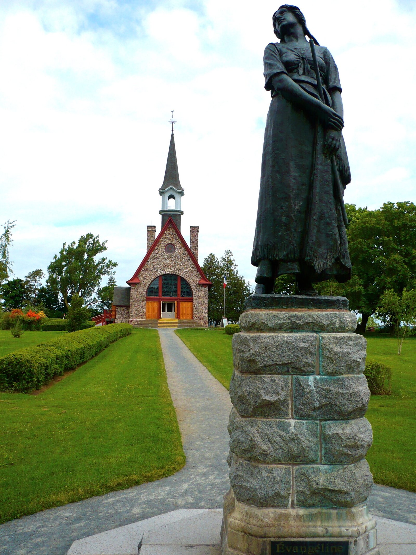
- Focal monument: Grand Pré Memorial Church (1922) and Evangeline statue, inspired by Longfellow’s 1847 poem
History
Acadian settlement of Grand Pré (meaning “great meadow”) began around 1680 CE, when French colonists from the earlier settlements at Port-Royal began extending their dyke-building techniques into the rich tidal marshes of the Minas Basin. The Bay of Fundy has the highest tides in the world — up to 16 metres — creating vast intertidal mudflats that are nutrient-rich but flooded twice daily with salt water. The Acadians, drawing on techniques brought from the dyked polders of western France (the Poitou-Charentes region), developed the aboiteau: a dyke system with a wooden box culvert fitted with a hinged clapper valve that swings outward to allow drainage at low tide and swings closed under pressure from the incoming tide. Over several generations, the Acadians reclaimed thousands of hectares of marsh, creating the fertile “grand pré” that gave the settlement its name.
By 1755, Grand Pré was the largest Acadian community in Nova Scotia, with several hundred families, a church, mills, and extensive orchards and farmland. The village stood at the intersection of French and British imperial rivalry for control of Acadia (present-day Nova Scotia and New Brunswick). In September 1755, British Lieutenant Colonel John Winslow assembled the Acadian men of Grand Pré in the church and read the order of deportation: all Acadian lands and property were forfeit to the Crown, and the population would be transported to other British colonies. The ensuing deportation — the Grand Dérangement — was one of the largest forced displacements in North American colonial history. Families were separated, ships were overcrowded, and many died at sea or in epidemics in their destinations. Those transported to Louisiana became the ancestors of the Cajun people; others eventually returned to Maritime Canada or settled in France.
The Grand Pré site became a pilgrimage destination for the Acadian diaspora following Henry Wadsworth Longfellow’s 1847 poem “Evangeline, A Tale of Acadie,” which transformed the deportation into a romantic epic and made Evangeline a national symbol for Acadian identity. The Dominion Atlantic Railway built a commemorative park at the site in 1907, and the memorial church was constructed in 1922. The dykes themselves continued in agricultural use — as they do today.
What you see
The landscape itself is the monument. Grand Pré presents an unusually legible cultural landscape: the geometric grid of dyked fields stretching to the tidal shore, the low ridgeline of dyke earthworks visible at the field margins, and the agricultural plain backed by the low ridge of the Gaspereau Valley. The tidal bore of the Bay of Fundy — rising and falling dramatically with the world’s highest tides — shapes the visual and ecological character of the entire landscape.
Within the commemorative park at the centre of the site, the 1922 Memorial Church is a small stone structure housing a museum with exhibits on Acadian history, culture, and the deportation. Beside it stands the bronze statue of Evangeline — the fictional heroine of Longfellow’s poem, now the most potent symbol of Acadian identity globally — set in formal gardens. The park is managed by Parks Canada as a National Historic Site and forms the core of the UNESCO World Heritage property. The surrounding farmland, still actively cultivated using dykes that descend from the Acadian originals (rebuilt and maintained over centuries), makes the landscape a living continuation of its founding community’s achievement.
Practical information
- Opening hours: Grand Pré National Historic Site — mid-May to mid-October, daily 09:00–17:30; grounds accessible year-round
- Admission: Adults CAD 4.00; Parks Canada Discovery Pass accepted
- On-site facilities: Visitor centre with Acadian history exhibits, gift shop, bilingual (English/French) interpretation
- Best season: Summer and early autumn for full apple orchards, dyke walks, and interpretive programs; the dyke landscape is striking in any season
- Acadian World Congress: Held every five years, drawing tens of thousands of Acadian diaspora members; Grand Pré is a central gathering point
Getting there
Grand Pré village is located approximately 90 km northwest of Halifax and 6 km east of Wolfville, off Highway 101 (Exit 10 for Grand Pré). By car from Halifax: approximately 1 hour on Highway 101. From Wolfville (6 km): by bicycle along the Harvest Moon Trail (former railway corridor) or by car. The nearest commercial airport is Halifax Stanfield International Airport. There is no regular public bus service directly to the site; a car is the practical requirement for visiting.
Nearby
- Wolfville — 6 km west; university town with restaurants, accommodation, and Acadian heritage sites
- Port-Royal National Historic Site — 80 km southwest; the first permanent European settlement north of Florida (1605), reconstructed trading post
- Cape Split Provincial Park — 30 km northwest; dramatic headland above the Bay of Fundy with views of the world’s highest tides
- Annapolis Royal — 90 km southwest; historic fortified town with the Fort Anne National Historic Site
Sources
Find it on the map
See this place and what’s around it →📷 Diventa un fotografo di Cultural Heritage Online
Condividi le tue foto dei luoghi: restano pubblicate con la tua firma come autore. Più vengono viste, più ti fai conoscere — e presto un concorso premierà le foto più apprezzate.
Accedi o registrati gratis per aggiungere una foto