Al Qal’a of Beni Hammad
A ruined Berber mountain capital that stood for barely eighty years — yet whose minaret shaped the skylines of Marrakech and Seville before the city was swallowed by the desert.
At a glance
Al Qal’a of Beni Hammad is the best-preserved and most representative medieval Hammadid palace complex in the Maghreb. Built on a 1,418-metre mountain ridge in central Algeria, it served as the first capital of the Hammadid dynasty from its foundation in 1007 CE until its abandonment in 1090 CE following the catastrophic Banu Hilal invasion. Within those eighty years, the city developed palace complexes, a Grand Mosque whose minaret directly influenced the Koutoubia in Marrakech and the Giralda in Seville, and an extraordinary artificial lake pavilion. The site was so thoroughly destroyed that its location was forgotten for centuries, only rediscovered during excavations in 1951. UNESCO inscribed it in 1980 as an outstanding example of early Islamic fortified architecture in North Africa.
Key facts
- UNESCO inscription: 1980 (among Algeria’s first WHS inscriptions)
- Location: Hodna Mountains, M’Sila Province, central Algeria; 1,418 m elevation
- Period: 1007–1090 CE (Hammadid dynasty, a Berber Sanhaja confederation)
- Site area: Enclosed by a 7-km circuit of defensive walls
- Key structures: Palace of the Lake, Grand Mosque (minaret standing 20 m of original c. 25 m), Dar al-Bahr (lake-pavilion complex)
- Architectural legacy: The minaret design directly influenced the Koutoubia Mosque (Marrakech) and the Giralda (Seville)
- Rediscovery: Site location unknown until French-led excavations began 1951
History
The Hammadids were a branch of the Zirid Berber dynasty who in 1007 CE broke away from their Zirid overlords and established an independent principality in central Algeria. Founder Hammad ibn Buluggin chose a dramatic mountain ridge in the Hodna range as the site for his new capital — a defensible position with commanding views over the high plateau. He named it Qal’at Bani Hammad, “the fortified city of the sons of Hammad.” Construction was rapid and ambitious: within decades the city had a Grand Mosque, several palace complexes, baths, water cisterns, and the remarkable Dar al-Bahr (House of the Sea), a palace built around an artificial lake measuring 67 by 47 metres, stocked with fish and equipped with boats for royal pleasure.
The Hammadid dynasty reached its cultural apex under Yahya ibn al-‘Aziz (r. 1055–1062) and al-Nasir ibn Alnas (r. 1062–1088), hosting poets, philosophers, and artisans from across the Islamic world. Then in 1052–1054 CE, the Fatimid caliph in Cairo — angered by Zirid abandonment of Shia Islam — unleashed the Banu Hilal tribal confederation westward from Egypt. The subsequent migrations and invasions devastated settled life across the Maghreb over several decades. Al Qal’a was abandoned around 1090 CE and never reoccupied. The stones were quarried for centuries by local populations, leaving only the lower courses of walls and the base of the minaret standing above ground. The 1951 excavations by French archaeologist Marguerite van Berchem revealed the city’s plan for the first time.
What you see
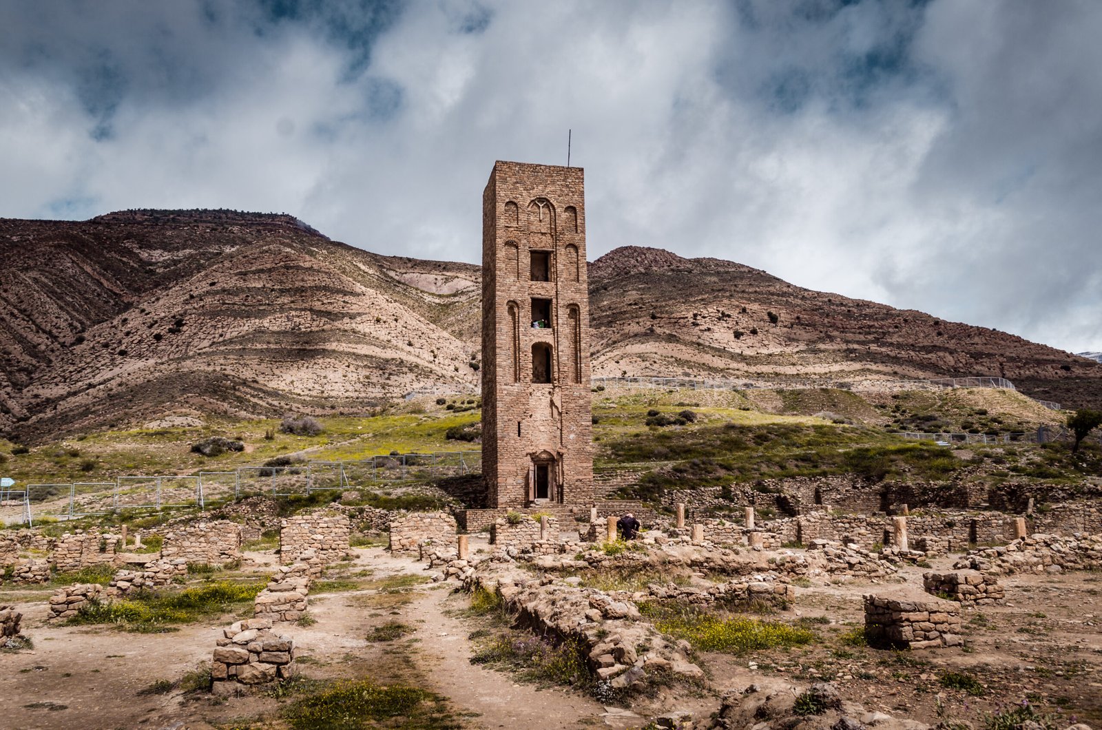
The ruined site is spread across a mountain ridge with expansive views over the Hodna plain. The most prominent surviving element is the minaret of the Grand Mosque — the oldest surviving monument of its kind in Algeria. Standing approximately 20 metres (of an original estimated 25 metres), it is a square tower of dressed stone with interlocking geometric patterns that became the template for the great minarets of the western Islamic world. Scholars have traced direct architectural descent from this minaret to the Koutoubia Mosque in Marrakech (1158 CE) and, via the Almohad dynasty, to the Giralda bell tower in Seville (originally the minaret of the Great Mosque of Seville, built 1184 CE).
The Palace of the Lake occupies the eastern portion of the site. The excavated foundations reveal a complex organised around the artificial lake, with pavilions projecting over the water on stone platforms and a monumental gateway decorated with carved stucco panels — fragments of which survive in Algeria’s national museum. The 7-km circuit of defensive walls, built of dressed limestone and reinforced with towers, encloses an area of approximately 100 hectares, indicating a city designed for a substantial population that never fully materialised before the site’s abandonment.
Practical information
- Opening hours: Daily, generally 08:00–17:00; confirm locally as hours vary seasonally
- Admission: Small site entry fee (approximately 200 DZD); guided tours available through the site office
- On-site museum: Small museum displays excavated ceramics, architectural fragments, and carved stucco panels
- Terrain: Uneven mountain terrain; sturdy footwear recommended; exposed site with strong winds at elevation
- Best season: Spring (April–May) and autumn (September–October) for mild temperatures; site is cold and windy in winter
Getting there
The site is located approximately 36 km north of M’Sila city, the provincial capital. From M’Sila, take the N45 road north toward Maadid, then follow signs to the site. M’Sila is connected to Algiers (260 km west) by the N60 national road; journey time from Algiers by car is approximately 3.5 hours. The nearest airport is Batna (Mostefa Ben Boulaid Airport), approximately 120 km east. Public transport to the site is limited; private car or organised tour from M’Sila or Algiers is the practical option.
Nearby
- M’Sila city — 36 km south; provincial capital with accommodation and services
- Timgad (ancient Thamugadi) — 120 km east; UNESCO-listed Roman colonial city (1982), the “Pompeii of North Africa”
- Djémila (ancient Cuicul) — 170 km northeast; UNESCO-listed Roman city of exceptional preservation (1982)
- Tiddis — 180 km northeast; Roman Berber hilltop city with remarkable views over Constantine
Sources
Find it on the map
See this place and what’s around it →📷 Diventa un fotografo di Cultural Heritage Online
Condividi le tue foto dei luoghi: restano pubblicate con la tua firma come autore. Più vengono viste, più ti fai conoscere — e presto un concorso premierà le foto più apprezzate.
Accedi o registrati gratis per aggiungere una foto