Historic Area of Willemstad, Inner City and Harbour
The pastel-painted Dutch colonial streetscapes of Willemstad — their vivid yellows, pinks, and blues reflected in the waters of St. Anna Bay — are among the most photographed facades in the Caribbean, a visual paradox born of 17th-century Dutch pragmatism transplanted onto a tropical island and never quite letting go of its origins.
At a glance
The historic inner city and harbour of Willemstad, capital of Curaçao, was inscribed as a UNESCO World Heritage Site in 1997. The city centre is divided into two historic districts — Punda (east) and Otrobanda (west) — separated by the Sint Annabaai channel and connected by the Queen Emma Pontoon Bridge, a floating pedestrian walkway that swings open on a pivot to allow ship traffic to pass. Together the two districts form one of the most complete and intact examples of Dutch colonial urban architecture in the world, built and continuously adapted between the 17th and 19th centuries.
Willemstad is also the oldest continuously inhabited European colonial settlement in the Caribbean, and its harbour — one of the finest natural deep-water ports in the Western Hemisphere — made it a critical hub of the Atlantic trade, including the slave trade, during the 17th and 18th centuries.
Key facts
- UNESCO inscription: 1997
- Location: Curaçao, Kingdom of the Netherlands (ABC Islands)
- Historic districts: Punda (east) and Otrobanda (west)
- Key crossing: Queen Emma Pontoon Bridge (floating pedestrian bridge, opens for ships)
- Architectural style: Dutch colonial, 17th–19th centuries, with tropical colour palette
- Oldest synagogue in the Americas: Mikve Israel-Emanuel Synagogue, 1732
- Founding: c. 1634 CE by the Dutch West India Company
- Coordinates: 12°06′N, 68°56′W
History
The Dutch West India Company (WIC) seized Curaçao from Spain in 1634 and quickly recognised the value of the island’s Schottegat — a large natural lagoon with a narrow entrance that provided a perfectly sheltered deepwater harbour. The settlement that grew at the mouth of the Sint Annabaai became Willemstad, named after William II of Orange. Within decades it had developed into one of the most important trading hubs in the Atlantic world.
Curaçao became the largest slave-trading post in the Dutch colonial empire. Enslaved Africans transited through Willemstad in enormous numbers en route to plantations across the Caribbean and South America. The city’s prosperity — visible in its substantial merchants’ houses and public buildings — was built on this trade. The WIC also made Willemstad a free-trade port, attracting Sephardic Jewish merchants expelled from Brazil after the Portuguese reconquest of Recife in 1654; their community built the Mikve Israel-Emanuel Synagogue in 1732, the oldest continuously active synagogue in the Americas.
The characteristic bright-colour facades of Punda became the defining image of the city. A popular local legend attributes the tradition to a Governor-General who claimed that white buildings gave him headaches and ordered buildings painted in colour, though historical evidence for this story is thin. In reality the colours likely developed gradually through the 18th and 19th centuries as local taste and tropical practicality diverged from the restrained palette of the Dutch homeland.
What you see
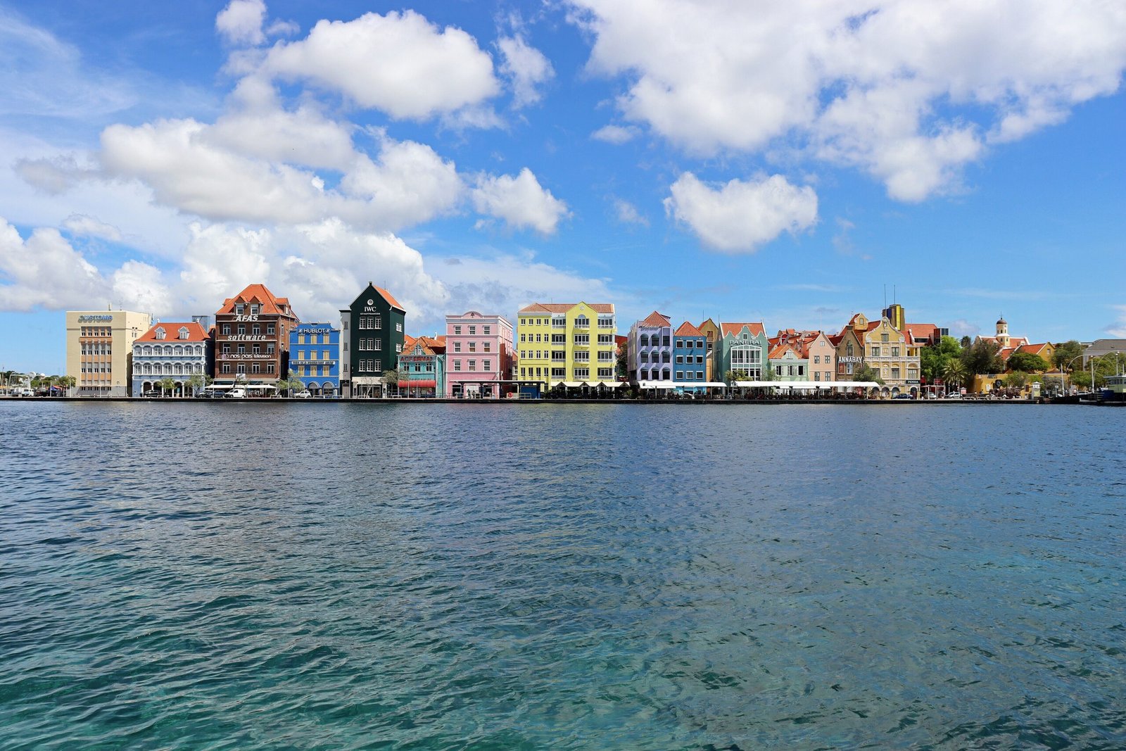
The Handelskade (Trading Quay) in Punda is the most iconic streetscape: a continuous row of 17th–19th-century merchant houses, their stepped or curvilinear gable facades painted in luminous tropical colours, rising directly from the waterfront of Sint Annabaai. The ground floors of many were once warehouses; today they house shops, restaurants, and offices.
The Queen Emma Pontoon Bridge connects Punda to Otrobanda at the narrowest point of the channel. When large ships pass — the port remains one of the busiest in the Caribbean — the bridge swings open on its pivot and pedestrians take a small free ferry. Otrobanda (literally “the other side”) has a more residential character, its 19th-century townhouses somewhat more subdued in colour than Punda but equally intact.
Fort Amsterdam at the southern end of Punda is the oldest standing structure in Willemstad, begun in 1635. The fort now houses the Governor’s Office of Curaçao, and its church — still with an English cannonball embedded in the wall from a 1804 raid — is open to visitors. The Mikve Israel-Emanuel Synagogue, a few blocks inland, is built on sand floors (a tradition recalling the desert wanderings) and contains one of the finest collections of early Jewish ceremonial objects in the Americas.
Practical information
- Access: Both Punda and Otrobanda are walkable city districts — no admission fee for the streets
- Fort Amsterdam: Governor’s Office and fort church; church open Mon–Fri, small entry fee
- Mikve Israel-Emanuel Synagogue: Open Mon–Fri, closed Jewish holidays; entry fee applies; museum attached
- Queen Emma Bridge: Free pedestrian crossing; free ferry when bridge is open for ships
- Best time: Morning or late afternoon for photography; midday sun bleaches the colour saturation
- Time needed: Half a day for Punda + Otrobanda; full day with museum visits
Getting there
Willemstad is the capital of Curaçao and the island’s main hub. Curaçao International Airport (CUR / Hato Airport) is approximately 12 km from the city centre; taxis take around 15–20 minutes. Regular flights connect from Amsterdam (KLM), Miami, New York, and several Caribbean hubs. Car hire is available at the airport; driving in the city centre is manageable, though parking in Punda is limited. The city districts are best explored on foot once you arrive.
Curaçao is a popular cruise destination; ships dock at the Mega Pier in Otrobanda or at the Rif Fort complex, both within walking distance of the historic core.
Nearby
- Rif Fort — 19th-century sea fort now converted into a shopping and dining complex at the harbour entrance
- Pietermaai District — a 19th-century residential quarter east of Punda, currently undergoing sensitive restoration with boutique hotels and restaurants
- Kura Hulanda Museum — the most important museum on the history of the transatlantic slave trade in the Dutch colonies, located in Otrobanda
- Scharloo — a once-wealthy Jewish merchant quarter adjacent to Punda, with grand Eclectic-style villas from the 19th century
- Christoffel National Park — 20 km northwest; rugged volcanic terrain with hiking trails to the island’s highest point
Sources
- UNESCO World Heritage Centre — whc.unesco.org/en/list/819
- Wikipedia — Willemstad
- Mikve Israel-Emanuel Synagogue — snoa.com
Find it on the map
See this place and what’s around it →📷 Diventa un fotografo di Cultural Heritage Online
Condividi le tue foto dei luoghi: restano pubblicate con la tua firma come autore. Più vengono viste, più ti fai conoscere — e presto un concorso premierà le foto più apprezzate.
Accedi o registrati gratis per aggiungere una foto