Quebrada de Humahuaca
A 10,000-year tapestry of human occupation pressed into a single Andean gorge: Inca fortresses, colonial missions, and vividly painted sedimentary mountains in one UNESCO World Heritage landscape in northwestern Argentina.
At a glance
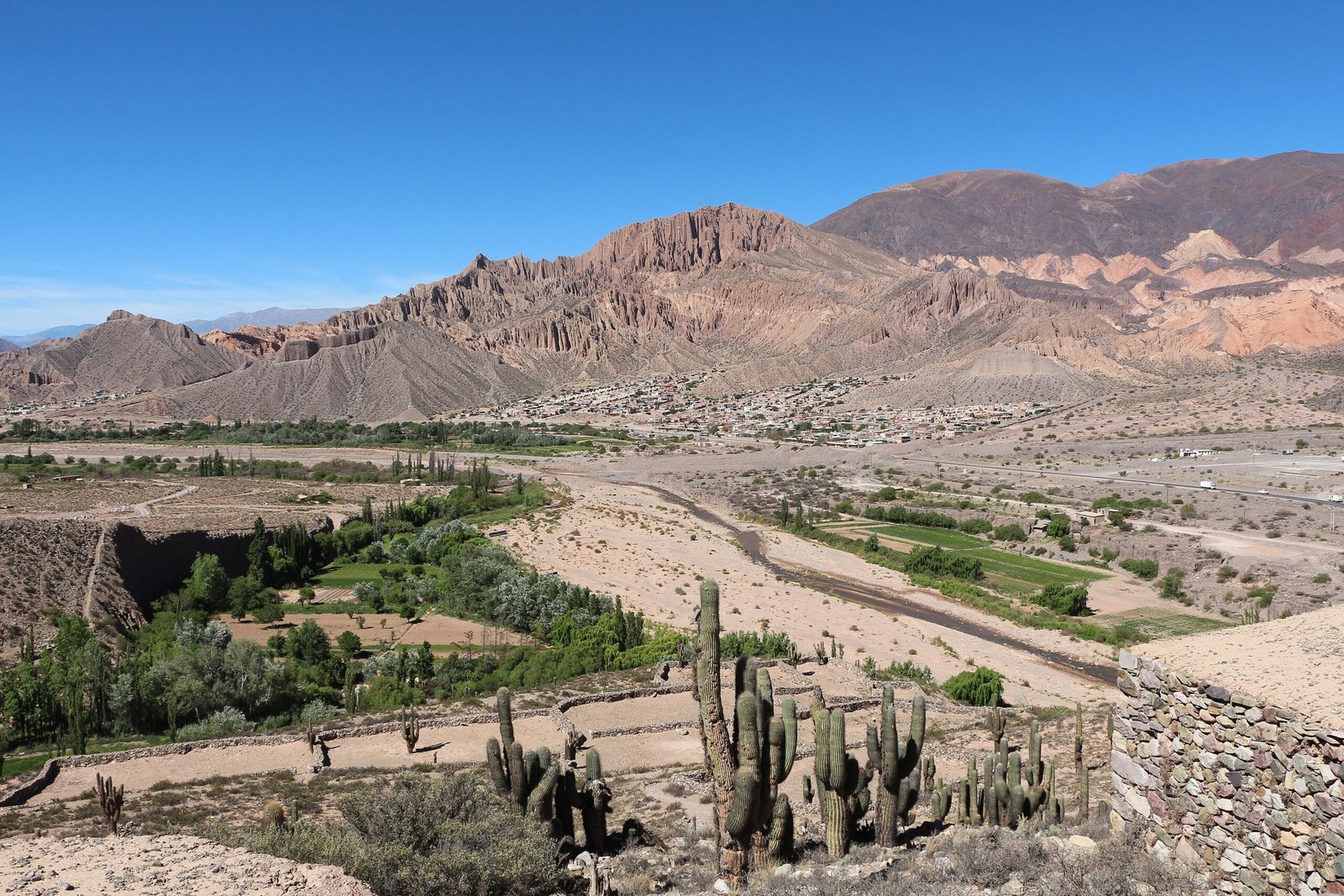
The Quebrada de Humahuaca is a narrow river valley carved by the Rio Grande into the high-altitude Andes of Jujuy Province in northwestern Argentina, stretching roughly 155 kilometres from its southern mouth near Volcan at 1,700 metres above sea level to the Bolivian border at over 3,400 metres. Inscribed as a UNESCO World Heritage Site in 2003 as an outstanding example of a living cultural landscape, the gorge concentrates an exceptional density of archaeological sites, colonial towns, Inca road segments, pre-Columbian fortresses, and Andean villages within a physically dramatic setting of layered, multicoloured sedimentary cliffs whose ochres, reds, purples, and yellows shift with the quality of the Andean light.
The valley has been a major route connecting the high Andean plateau (the puna) with the lowlands of the Rio de la Plata basin for at least 10,000 years, and its strategic importance as a corridor for trade, migration, and conquest is inscribed in its landscapes: Palaeolithic hunter-gatherer camps, Formative-period agricultural villages, the pre-Inca fortress of the Pucara de Tilcara, the Inca Qhapaq Nan royal road, and a string of colonial Spanish mission towns founded in the seventeenth century all survive within a single morning drive.
Key facts
- UNESCO inscription: 2003, as a cultural landscape (criteria II, IV, V)
- Altitude range: 1,700-3,400 m above sea level along 155 km
- Main river: Rio Grande de Jujuy
- Province: Jujuy, northwestern Argentina
- Earliest occupation: c. 9000 BCE (Palaeolithic hunters)
- Inca presence: late 15th century, Tawantinsuyu expansion
- Colonial period: Spanish conquest from 1590s; missions founded 17th century
- Independence battle: Starting point of the 1812 Gauchos de Guemes campaign
- Most visited site: Pucara de Tilcara (Inca-era fortress above the town of Tilcara)
- Iconic landform: Serrania de Hornocal — the “Hill of Fourteen Colours”
History
The earliest evidence of human activity in the Quebrada de Humahuaca dates to approximately 9000 BCE, when mobile hunter-gatherer groups camped along the river terraces pursuing the megafauna of the high Andes. By around 500 BCE, semi-sedentary agricultural communities had established themselves in the valley, cultivating maize, quinoa, and potato on terraced fields and herding llamas and alpacas — a pattern of transhumance between the valley floor and the high puna pastures that persists to this day in attenuated form.
Between approximately 900 and 1450 CE the valley was occupied by a succession of local chiefdoms known collectively as the Omaguaca or Humahuaca people, whose fortified hilltop villages (pucaras) controlled the corridor strategic junctions. The most extensively excavated of these pre-Inca centres, the Pucara de Tilcara, shows a complex urban layout of stone-built rooms, plazas, and ceremonial structures covering the summit of a natural promontory above the confluence of the Rio Grande and the Rio Huasamayo.
In the late fifteenth century, the expanding Inca empire (Tawantinsuyu) absorbed the gorge, incorporating its pre-existing settlements into the imperial road network (the Qhapaq Nan), constructing tambos (way stations) at regular intervals along the valley, and imposing mitmaqkuna (transplanted labour colonies) to exploit agricultural resources. Spanish conquistadors entered the valley from Peru in the 1530s and 1540s, and permanent colonial settlements were established from the 1590s onwards. The gorge was a contested military zone during the Argentine War of Independence (1810-1825), and the figure of the gaucho fighter Martin Miguel de Guemes, who organised irregular cavalry resistance in the passes above the Quebrada, remains a defining regional symbol.
What you see
The gorge offers a layered visual and archaeological experience that is virtually without parallel in South America. The dominant natural spectacle is geological: the valley walls display a compressed sequence of sedimentary formations whose different mineral contents produce a chromatic palette — vivid reds from iron oxide, white from limestone, purple from manganese, yellow from sulphur — that intensifies dramatically at dawn and dusk when the low Andean light rakes across the cliff faces. The most extraordinary expression of this phenomenon is the Serrania de Hornocal, a folded ridge of limestone approximately 25 kilometres east of Humahuaca at 4,350 metres altitude, where the angular stratigraphy of the tilted beds creates a spectacle that Argentine photographers have popularised as the “Hill of Fourteen Colours.”
The Pucara de Tilcara, the gorge best-known archaeological monument, sits on a natural plateau above the town of Tilcara and was partially reconstructed in the 1950s by Argentine archaeologist Eduardo Casanova, so that its stone walls and ceremonial structures give a clearer spatial impression of the pre-Inca urban layout than survives at most comparable Andean sites. The site museum adjacent to the pucara preserves ceramic, textile, and metalwork finds from the excavations. The colonial churches of the gorge — notably Santa Barbara in Humahuaca, San Francisco de Paula in Uquia, and the Cuzco school paintings in Tilcara church — constitute the most significant colonial ecclesiastical heritage of the Quebrada. The village of Purmamarca, at the foot of the multicoloured Cerro de los Siete Colores, is the most photographed townscape.
Practical information
- Access: Ruta Nacional 9 runs the length of the gorge; paved and all-weather
- Base towns: Tilcara (most facilities, central position), Purmamarca (picturesque, popular), Humahuaca (market town, northern gateway)
- Pucara de Tilcara: open daily; entrance fee; museum included; 30-90 minutes on site
- Serrania de Hornocal: accessible by 4WD or organised tour from Humahuaca; best light at 08:00-10:00; altitude 4,350 m — acclimatise first
- Best season: May-October (dry season, clearest skies); July-August is peak Argentine tourism; Carnival in February is spectacular but very crowded
- Altitude caution: Humahuaca at 2,940 m; spend at least one night at lower altitude before ascending to Hornocal; carry water
- Local market: Sunday market in Tilcara for textiles, ceramics, and food
- Photography: dawn and late afternoon give the best colour saturation on the cliff faces
Getting there
The main gateway city is San Salvador de Jujuy (locally “Jujuy”), the provincial capital, which has a domestic airport with regular connections to Buenos Aires (Aeroparque Jorge Newbery). From Jujuy, Ruta Nacional 9 heads north into the gorge; Purmamarca is approximately 65 kilometres from Jujuy (45 minutes by car), Tilcara about 85 kilometres (one hour), and Humahuaca approximately 130 kilometres (two hours). Long-distance buses from Buenos Aires (approximately 22-24 hours) and Salta (2.5 hours) serve both Jujuy and the principal towns of the gorge directly. Car hire in Jujuy or Salta is practical for independent exploration; the road is paved and presents no difficulties except for the Hornocal detour, which requires a high-clearance vehicle.
Nearby
- Salinas Grandes — vast salt flat at 3,450 m on the puna above Purmamarca (45 km by road); one of the most dramatic landscapes in South America
- Laguna de los Pozuelos — Ramsar-listed high-altitude wetland and flamingo colony, 160 km north of Humahuaca
- Salta city — 185 km south; colonial architecture, Cabildo museum, base for the Tren a las Nubes mountain railway
- Santa Catalina — well-preserved colonial Jesuit church near the Bolivian border, 170 km north
- Cueva de las Manos — UNESCO rock art site in Patagonian Santa Cruz Province; thematically linked as Argentina other great pre-Columbian heritage monument
Sources
- UNESCO World Heritage Centre — Quebrada de Humahuaca (WHC nomination file 1116, 2003)
- Raffino, Rodolfo — Poblaciones Indigenas en Argentina (TEA, Buenos Aires, 1988)
- Tarrago, Myriam N. — Historia Argentina Prehispanica, Vol. 1 (Editorial Critica, 2000)
- Fernandez Distel, Alicia A. — “Arqueologia de la Quebrada de Humahuaca” in Culturas Indigenas de la Argentina (FECIC, Buenos Aires, 1985)
- Wikipedia — Quebrada de Humahuaca (consulted June 2026)
Find it on the map
See this place and what’s around it →📷 Diventa un fotografo di Cultural Heritage Online
Condividi le tue foto dei luoghi: restano pubblicate con la tua firma come autore. Più vengono viste, più ti fai conoscere — e presto un concorso premierà le foto più apprezzate.
Accedi o registrati gratis per aggiungere una foto