Otrar (Farab)
The Silk Road frontier city where, in 1218 AD, the execution of a Mongol trade caravan triggered Genghis Khan’s invasion of Central Asia — one of the most consequential single acts in world history — and where Tamerlane died in 1405 en route to his planned conquest of China.
At a glance
Otrar — known in medieval Islamic geography as Farab, the birthplace of the philosopher Al-Farabi — stands at the confluence of the Arys and Syr Darya rivers in southern Kazakhstan. Occupied from the early centuries AD through the 18th century, the site reached its greatest historical significance in 1218 as a frontier city of the Khwarazmian Empire: the execution here of a Mongol trade mission and its diplomatic envoys gave Genghis Khan legal grounds under Mongol custom to wage unlimited retaliatory war, initiating a campaign that killed an estimated 15–40 million people. The ruins extend over approximately 200 hectares; a small archaeological park preserves the excavated citadel mound and sections of the medieval city walls.
Key facts
- Also known as: Farab (medieval Islamic sources)
- Notable native: Al-Farabi (c. 872–950 AD), philosopher and mathematician, “The Second Teacher” after Aristotle
- The 1218 incident: Governor Inalchuq executed a Mongol merchant caravan (~450 persons) and envoys, triggering the Mongol invasion of Central Asia
- Mongol siege: 1219 AD, five months; Inalchuq executed by having molten silver poured into his eyes and ears
- Timur’s death: Tamerlane died at Otrar, February 1405, while preparing to invade Ming China
- Area: approximately 200 hectares of excavated ruins
- Excavation: Systematic since the 1970s; protected archaeological site of Kazakhstan
History
Otrar’s origins lie in the agricultural oasis settlements of the Syr Darya basin dating to the early centuries AD. By the 8th century it was a significant Sogdian trading city; in the 9th–10th centuries, under Samanid rule and bearing the name Farab, it was known as a centre of Islamic learning. Its most famous native son, the philosopher Abu Nasr al-Farabi (c. 872–950 AD), extended Aristotelian philosophy within an Islamic framework and is known as “The Second Teacher” after Aristotle. The city passed through Qarakhanid, Kara-Khitan, and Khwarazmian control before the catastrophic events of 1218.
In 1218 AD, a Mongol trade caravan — estimates range from 450 to 500 merchants, accompanied by a Mongol imperial envoy — arrived at Otrar. The governor, Inalchuq Qadir Khan, accused them of espionage and had them arrested and executed. The Khwarazmian Shah Muhammad II, rather than punishing the governor, had the subsequent Mongol diplomatic mission demanding retribution similarly executed. Under Mongol law, this double violation of merchant and diplomatic immunity left Genghis Khan with no course except total war. The campaign he launched in 1219 was among the most destructive in history: Samarkand, Bukhara, Merv, Nishapur, and Urgench were sacked; scholars estimate total deaths in the tens of millions. Otrar itself was besieged for five months; Inalchuq, captured alive, was put to death in a symbolically appropriate manner for a man who had killed merchants for their gold.
The site was rebuilt under Mongol and later Timurid rule as a regional administrative centre. In February 1405, Timur — Tamerlane — fell ill and died at Otrar while his army assembled for the invasion of Ming China; his body was returned to Samarkand for burial in the Gur-e-Amir mausoleum. Otrar declined gradually after the 15th century and was finally abandoned in the 18th century as the Syr Darya shifted course and the sustaining oasis agriculture collapsed.
What you see today
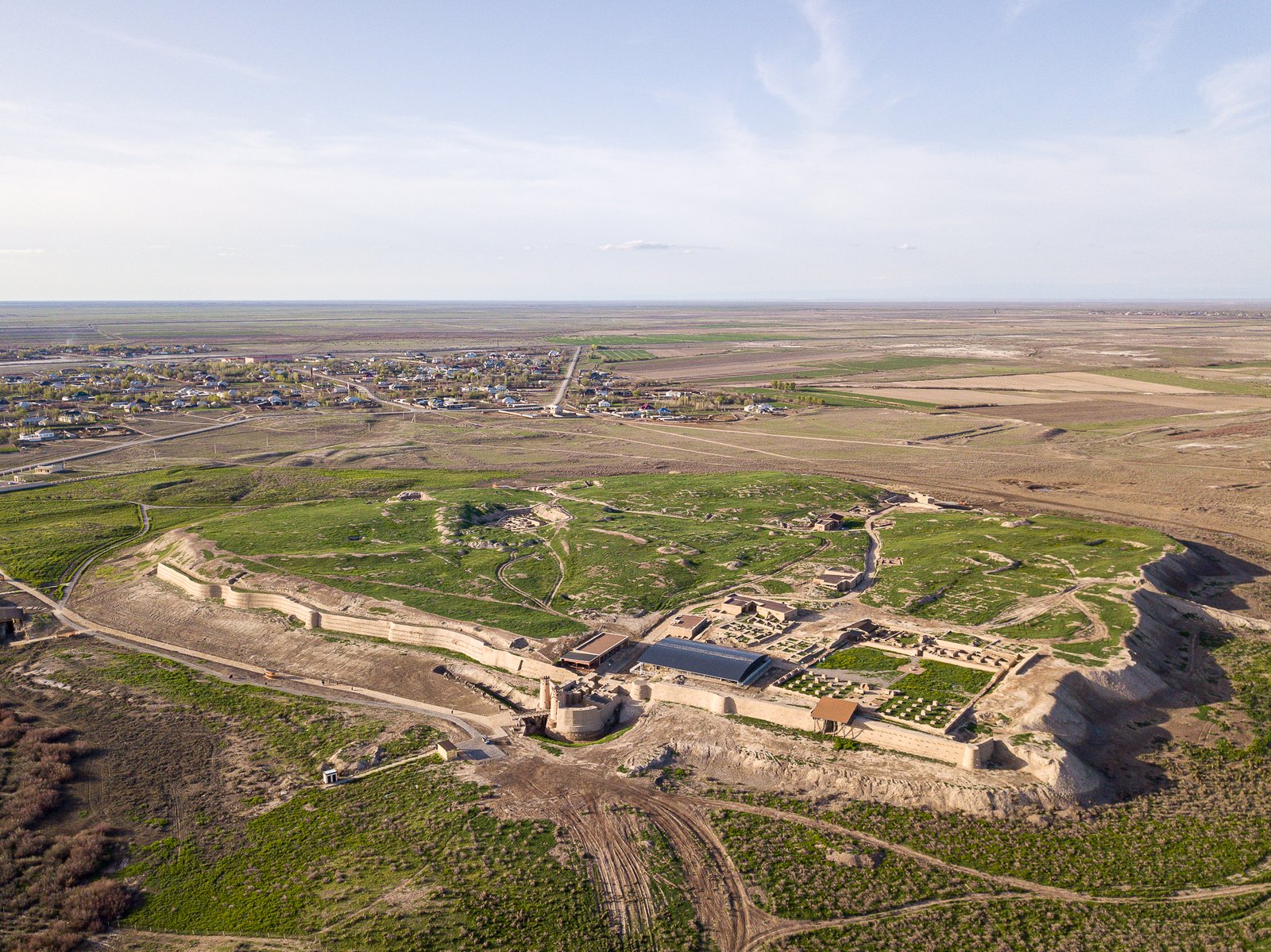
The site presents as a broad flat plain of compacted earth and debris rising at its centre to the citadel mound (Otrar-Tobe). Excavations since the 1970s have revealed the grid plan of the medieval city, including streets, residential quarters, a large mosque, a caravanserai, and a bathhouse — all in mudbrick construction characteristic of Central Asian urban architecture. The citadel mound has been partially excavated and consolidated; sections of the outer city wall survive on the south and east sides.
A small museum and archaeological park at the entrance provides interpretive context and displays ceramics, coins, and architectural fragments spanning twelve centuries of occupation. The flat steppe landscape around the site makes clear why the confluence of two rivers was of such strategic importance: Otrar controlled both the river crossings and the adjacent agricultural oasis, the only reliable food and water supply on this section of the Silk Road.
Practical information
- Location: Near the village of Shauldyr, Otrar District, Turkestan Region; approximately 160 km north of Shymkent
- Opening: Site accessible year-round; museum hours vary seasonally
- Entry: Small admission fee for the archaeological park and museum
- Best season: April–June and September–October; summers are extremely hot on the open steppe
- Duration: Allow 2–3 hours for site and museum
- Facilities: Minimal at site; full services in Shymkent (160 km south)
Getting there
Otrar is approximately 160 km north of Shymkent in southern Kazakhstan, accessible by road via the M39 highway and local roads through the village of Shauldyr. There is no public transport directly to the archaeological site; visitors travel from Shymkent by private car, taxi, or organised tour. Shymkent has its own international airport (SCO) with flights to Almaty, Astana, and several regional destinations. Nearest railway station: Timur junction near the site, on the Almaty–Tashkent main line, though onward transport requires a vehicle.
Nearby
- Turkestan city (100 km north) — Khoja Ahmed Yasawi Mausoleum, finest surviving Timurid architecture, UNESCO World Heritage Site
- Shymkent (160 km south) — regional city with museums covering the Silk Road and pre-Mongol Central Asian cultures
- Sauran ruins (80 km north) — medieval city walls of a Silk Road oasis town, largely intact above ground
Sources
- Karl Baipakov, Medieval Cities of Kazakhstan, Almaty, 1998
- Timothy May, The Mongol Conquests in World History, Reaktion Books, 2012
- René Grousset, The Empire of the Steppes, Rutgers University Press, 1970
- Encyclopaedia Iranica, “Farab,” iranicaonline.org
Find it on the map
See this place and what’s around it →📷 Diventa un fotografo di Cultural Heritage Online
Condividi le tue foto dei luoghi: restano pubblicate con la tua firma come autore. Più vengono viste, più ti fai conoscere — e presto un concorso premierà le foto più apprezzate.
Accedi o registrati gratis per aggiungere una foto