Mapungubwe
The flat-topped sandstone hill at the confluence of the Limpopo and Shashe rivers was the royal seat of sub-Saharan Africa's earliest known kingdom — a stratified Iron Age state whose hilltop elite buried their dead with objects of pure gold, including the celebrated Golden Rhino that became South Africa's national symbol.
At a glance
Mapungubwe (meaning "place of the jackal" in Northern Sotho) flourished as the capital of a powerful Iron Age kingdom between approximately 1220 and 1290 AD, commanding the fertile lowveld at the junction of three modern nations — South Africa, Zimbabwe, and Botswana. At its height the capital may have housed 5,000 people, organised into a strictly hierarchical social structure visible in its burial practices: commoners in the valley, elites on the lower slopes, royalty on the sealed hilltop summit. Trade connections ran via the Swahili coast to India and China. The kingdom collapsed around 1290 AD, apparently because of a regional climate shift that dried the Limpopo valley, shifting power northward to the emerging state of Great Zimbabwe. The site was inscribed as a UNESCO World Heritage Site in 2003.
Key facts
- Location: Northern Limpopo Province, South Africa — at the confluence of the Limpopo and Shashe rivers, near Musina
- Period: c. 1000-1300 AD; kingdom peak c. 1220-1290 AD
- Culture: Mapungubwe Iron Age culture; predecessor of the Zimbabwe Tradition
- UNESCO status: World Heritage Site since 2003 (Mapungubwe Cultural Landscape)
- Key find: The Mapungubwe Golden Rhino — gold foil over wooden core, 15 cm long, discovered 1934 in a royal hilltop burial
- Population at peak: Estimated 5,000 at the capital; total polity possibly tens of thousands
- Access: Via Mapungubwe National Park (SANParks); guided tours required for the hilltop summit
History
The Mapungubwe story begins around 900 AD in the Shashe-Limpopo Basin, where Bantu-speaking farming communities settled the fertile floodplain and began accumulating cattle-based wealth. By around 1000 AD a chiefdom centred on Schroda Hill had established trade connections with Indian Ocean merchants via the Swahili coast, exchanging ivory and gold for glass beads and glazed ceramics from Persia and China. Around 1220 AD power shifted to Mapungubwe Hill itself and the settlement transformed structurally: the hilltop was reserved exclusively for the ruling family and sealed from ordinary access, creating the first clear physical separation between rulers and ruled in southern African archaeology.
The 1934 excavation by University of Pretoria students — conducted clandestinely and in violation of laws that excluded Black South Africans from the site during the apartheid era — uncovered three royal burials on the hilltop containing extraordinary gold objects: the Golden Rhino, a sceptre and bowl in gold foil, beadwork, and copper items. These objects were suppressed under apartheid and only publicly acknowledged in the 1990s after South Africa's democratic transition. Today the Golden Rhino is at the University of Pretoria Museum, and the Order of Mapungubwe is South Africa's highest civilian honour.
The kingdom's decline around 1290 AD appears linked to a southward shift of the inter-tropical convergence zone that made the Limpopo valley progressively drier, collapsing the agricultural base. Power and trade networks shifted northward to Great Zimbabwe, which rose to dominance over the following century using the same Swahili coast routes and the same gold-and-ivory economy that Mapungubwe had pioneered.
What you see today
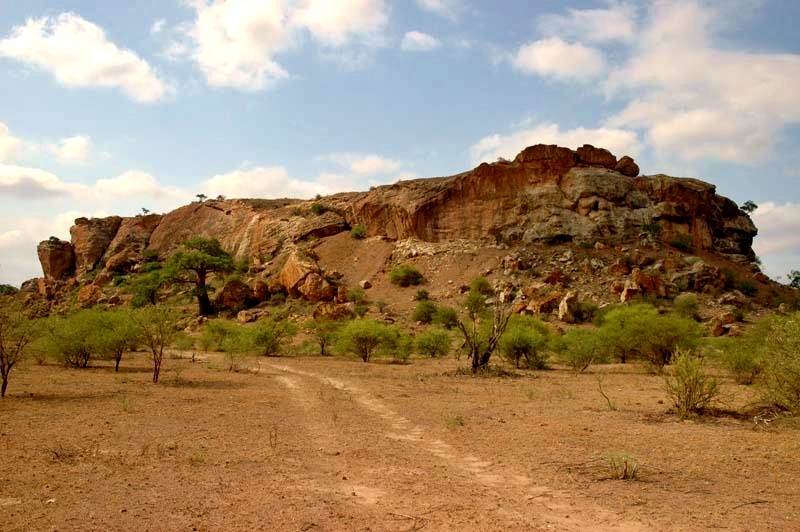
Mapungubwe sits within a national park of extraordinary natural beauty — the confluence region where three countries meet is one of southern Africa's most biodiverse zones, with baobab woodland, fever trees, and populations of elephant, buffalo, and roan antelope. The archaeological remains on the hilltop are modest by comparison with their significance: erosion and early excavation have stripped much of the surface, but the sheer topography communicates immediately why this was chosen as a royal seat. Palace walls, grain storage pits, and terracing of the royal enclosure are visible on guided walks.
The Mapungubwe Interpretation Centre at the park entrance, designed by Peter Rich Architects (winner of the 2009 World Architecture Festival Award), is architecturally distinguished: a vault structure built from compressed earth tiles in a form inspired by Mapungubwe Hill's own profile. The centre holds casts of the gold objects (originals remain at the University of Pretoria) and an exhibition on the Iron Age political economy of the Shashe-Limpopo Basin. Access to the hilltop is by guided tour only; the hill is still considered sacred by local Venda and Sotho communities.
Practical information
- Park entry fee: SANParks conservation fee applies; see sanparks.org for current rates
- Guided tours: Required for the hilltop; depart from the Interpretation Centre; advance booking recommended in peak season (June-August)
- Best time to visit: May-September (dry season, cooler, wildlife more visible); October-April is hot and wet
- Malaria zone: Yes — prophylaxis recommended; consult your physician before travel
- Accommodation: Mapungubwe National Park has chalets and camping; lodges available in the Greater Mapungubwe Transfrontier Conservation Area
- Photography: Permitted in park; drone use requires advance SANParks permit
Getting there
Mapungubwe National Park is in Limpopo Province, approximately 75 km west of Musina via the N1 north and then west on the R572 toward Pontdrift. The nearest international airports are Johannesburg O.R. Tambo (approximately 500 km south) and Polokwane International (approximately 300 km south). There is no public transport to the park; a 4WD is recommended for internal tracks. Fill up with fuel in Musina or Alldays — none is available inside the park.
Nearby heritage
- Great Zimbabwe (Zimbabwe, 300 km north) — the larger Iron Age stone-walled capital that succeeded Mapungubwe in regional dominance, c. 1300-1450 AD; UNESCO WHS
- Thulamela (Kruger National Park, 90 km east) — an Iron Age hilltop royal enclosure, c. 1400-1700 AD; a direct cultural descendant of the Mapungubwe tradition
- Vhembe Biosphere Reserve — the wider landscape within which Mapungubwe sits, recognised by UNESCO as a biosphere reserve
Sources
- Huffman, T.N. (2005). Mapungubwe: Ancient African Civilisation on the Limpopo. University of the Witwatersrand Press.
- UNESCO World Heritage Convention — Mapungubwe Cultural Landscape (2003). whc.unesco.org/en/list/1099
- Meyer, A. (1998). The Archaeological Sites of Greefswald. University of Pretoria Press.
- SANParks — Mapungubwe National Park. sanparks.org/parks/mapungubwe
- Wikipedia — “Mapungubwe” (accessed June 2026).
Find it on the map
See this place and what’s around it →📷 Diventa un fotografo di Cultural Heritage Online
Condividi le tue foto dei luoghi: restano pubblicate con la tua firma come autore. Più vengono viste, più ti fai conoscere — e presto un concorso premierà le foto più apprezzate.
Accedi o registrati gratis per aggiungere una foto